

MN weather: Timeline of what to expect with Sunday's snow

MN weather: What to expect for Sunday's snow
Sunday will bring a spring snowstorm with potential heavy snow and strong winds. Snow total expectations vary widely across the state. Winds are expected to be 25-30 mph with gusts possibly getting up to 40 mph.
MINNEAPOLIS (FOX 9) - A spring snowstorm will bring the potential for heavy snow, strong winds, and rain to Minnesota starting Sunday.
READ MORE: Minnesota, Wisconsin school closings, delays for March 25, 2024
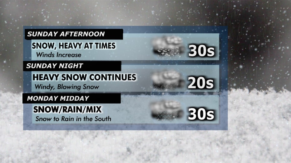
Patchy, light snow is expected Sunday morning, which will develop into wet heavy snow Sunday afternoon-evening in the Twin Cities. The heavy snow will likely then transition into rain by Monday morning.
READ MORE: The latest on Sunday's spring snowstorm
Here's a timeline of what to expect Sunday into Tuesday:
- Sunday morning: Patchy, light snow continues Sunday morning into Sunday afternoon.
- Sunday evening: Snow continues to come down over a large area of the region. Snow and blowing snow are expected. Reduced visibility and tough travel are likely. Heavy snow is possible at times.
- Sunday night: Mainly snow still. Heavy at times. Gusty east winds. Tough travel, with 1-plus inch-an-hour snow rates possible (not the whole time, but at points in the evening and overnight).
- Monday morning: Snow to the west and north. Moderate and potentially still heavy here and there. Blowing snow for western and northwestern Minnesota with strong gusts out of the north and northeast. Rain will move into southern Minnesota. Rain starts to melt and compact snow in those areas. The transition from snow to rain is looking to occur sometime in the morning hours for the Twin Cities metro. This likely will happen for the southern metro first and northern and northwest metro a touch later.
- Monday lunchtime: Snow and wind continue to the west, central, and northern Minnesota. Rain showers and areas of dry air will move into south-central and southeastern Minnesota.
- Monday evening: Areas of snow and wind are still possible over western and northern Minnesota. Dry air is likely to be wrapped into this system, creating big changes from areas of no precipitation to areas of snow (or rain showers). A few thundershowers may pop up in southeastern Minnesota, with rumbles in the southeast.
- Tuesday morning: The tail end of this system. Breezy with northwest winds. A few areas of light snow and some blowing snow, but minor accumulations are expected late into the storm. Colder temperatures will slowly invade the Northern Plains and Upper Midwest – especially for Wednesday.
Expected snow totals
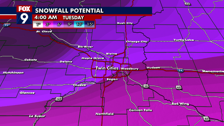
Forecast snow totals for Sunday's snowstorm.
The way this storm is setting up may lead to a big contrast in snow accumulations – even across the Twin Cities. Higher amounts are expected in the northwest Twin Cities metro and even more so as you head northwest on Interstate 94 toward St. Cloud. We’ll likely see less in the southern and southeastern areas of the Twin Cities. The warmer temperatures along with the heavy snow will lead to compacting snow, and it won’t just pile up and up and up. As even warmer air arrives heading into Monday morning and especially throughout the day on Monday, we’ll see areas of rain helping to melt our freshly fallen snow.
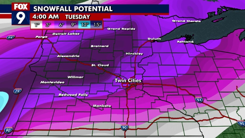
Snow will vary widely from southern Minnesota up into central and north central parts of the state. Upwards of 6 to 9 inches of snow is looking likely for western central Minnesota through north central and into northern Minnesota. Across the metro, expect snow totals to vary widely. Less snow is expected in the south and southeastern parts of the Twin Cities, with more snow expected farther northwest.
Isolated areas may briefly make it above this range. Measuring snow may be difficult due to how heavy it is expected to be. Compacting and melting will occur during this snowstorm. The rain that is expected to move in to southern Minnesota on Monday will also start to melt and compact snow that fell on Sunday and Sunday night.
Weather warnings
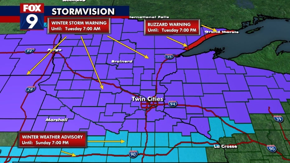
A few winter weather alerts are in effect starting Sunday:
- A winter weather advisory is in effect Sunday for southern Minnesota along the Iowa border.
- A winter storm warning is in effect Sunday for the majority of the state, including the Twin Cities, northwestern Minnesota, most of the southwestern part of the state and all of central Minnesota.
- A blizzard warning is in effect Sunday for far northeastern Minnesota.