

Urban heat island in full display Thursday morning
(FOX 9) - On frigid tranquil mornings, you can get a really good idea just how much humans effect the world around us. A vast majority of the time, most of our ramifications on our world are invisible to all of our senses. While we can’t exactly walk outside simultaneously in two different locations to be able to feel how different the temperatures are, we have the technology now that can do that for us, in a manner of speaking.
While, yes, a thermometer is the easy way to compare actual air temperatures, there is a better way to get a very clear picture of how humans effect the atmosphere. Now, I’m not here to debate climate change one way or another. That debate will rage on, but one thing that cannot be disputed is the urban heat island effect. This is a scientifically proven fact.
The urban heat island is the warming effect man-made objects have on the environment around them. Asphalt, concrete, brick, metal--everything that is used to build our cities all hold more heat than the grass, plants and trees that make up Earth’s natural surface. With a vast network of buildings and roads in cities, most surfaces go from natural to manmade.
With all of these surfaces holding more heat, temperatures in these areas are often times warmer than the natural areas around them. In some cases, significantly warmer. There have been documented cases that the “core” of the Twin Cities is 30 degrees warmer than surrounding more rural areas like Waconia, Buffalo, Cannon Falls, or even River Falls, Wisconsin.
This urban heat effect is magnified on calm, clear nights and mornings, especially in the winter with snow on the ground. Here are actual air temperatures from the 6am hour across the Twin Cities and greater Minnesota.
Notice two things with the metro core. Most of the metro is much warmer than surrounding areas. But, there are a couple of colder locations. The reason? These are in low spots, where cold dense air can get trapped, allowing temperatures to fall even further than they otherwise could. But for the most part, the Twin Cities metro is much warmer than surrounding rural areas.
A better and really cool way to see this is through technology known as the Infrared Satellite. The image below comes from this satellite.
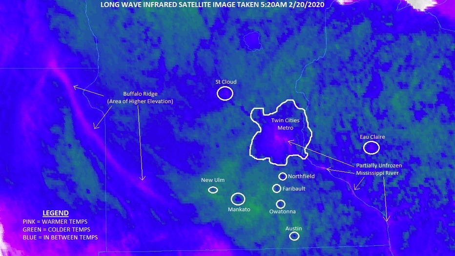
Urban heat island as seen from an infrared satellite orbiting the Earth
This is an image taken early Thursday morning showing central and southern Minnesota, parts of the eastern Dakotas, extreme northern Iowa and western Wisconsin.
Infrared satellites use a color spectrum to show temperatures. Green areas are colder zones, pink areas are warmer zones, and the blue areas are the zones in between. Notice the areas I circled. The little blobs of blue inside the green areas in southern Minnesota are many of the cities in southern Minnesota, from Mankato to Faribault and Owatonna, most show up as warm spots in between the cold rural areas. Even New Ulm appears! Yes, even much smaller cities have a urban heat effect. It’s just on a much smaller scale.
Now, notice the blob that is the Twin Cities. All of these areas are warmer than surrounding spots, but notice how it is a gradual transition as you head through the suburbs and into the far more densely industrialized city core. Those areas are the much warmer zones shaded in pink. Also having an influence are natural areas, like rivers that aren’t completely frozen over (because liquid water is obviously far warmer than ice) like the Mississippi from the Twin Cities all the way down to La Crosse.
You can also see spots with higher elevation like the Buffalo Ridge in southwest Minnesota and eastern South Dakota. This is because frigid air is very dense and will often find the lowest locations to settle. It is these morning where even small changes in elevation can make a big difference in temperature…a lot like those low spots in the Twin Cities I pointed out in the temperatures above, as well as elongated ridges like in southwest Minnesota.
This urban heat island effect will likely only get more productive as the Twin Cities and surrounding areas continue to grow. One day this could really hinder the Twin Cities from getting too far below zero. We have already seen a drastic decrease in the number of calendar days where temperatures get below minus 10 and that number will likely continue dropping.
Before you get too carried away thinking that that’s a good thing, just know that with warmer overnight lows in the winter, more pests, bugs, and parasites can survive the winter season meaning that both animal, plant and human diseases could increase because of it. But, that can be explained in greater detail another day. Stay warm!