

More melting, possible record warmth on Christmas Eve
(FOX 9)
(FOX 9) - Our late December thaw continues Friday.
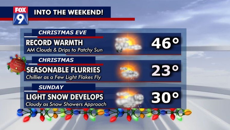
Friday morning, we climbed back above freezing in the wee hours of the day at 2 a.m. We continue to build upon Thursday's highs near 40 by pushing temperatures into the middle 40s in the afternoon. Not only would that obviously lead to more melting, but it flirts with record warmth as our current record for Christmas Eve is 46 degrees set back in 1957.
The warmer air surging our way brings a few extra clouds and very random and light drips or sprinkles this morning. However, a change in wind direction allows some patchy sun to shine Friday afternoon as temperatures head deep into the 40s.

Warm Christmas Eve, possible flurries Christmas Day
It will be a mild, warm Christmas Eve with temperatures in the middle 40s this afternoon, possibly breaking the record for warmth on this day. Colder air will return overnight and we could see a dash of flurries or light flakes in the Twin Cities metro on Christmas Day with a few inches possible up north.
Colder, more seasonable temps in the teens return Friday night and into a bright Christmas morning, but snow lovers DO have a shot of a few flying flurries by Christmas afternoon. They probably won't amount to much more than a dusting in the Twin Cities, but a couple of inches are possible across northern Minnesota.
Another system rolls in from the southwest on Sunday, bringing a high near 30 and snow showers that slowly cross the state through the afternoon & into Sunday night. It's too early for specifics, but a general swath of 2-4 inches is possible as we wake up Monday morning (keep an eye for updates throughout the weekend).
Winter lovers get another accumulating shot at snow into Tuesday before some frigid temps return midweek to wrap up the year on a COLD note.
Download the FOX 9 Weather App to track winter weather live on your phone, with future radar, school closings, livestreaming video of FOX 9 coverage and alerts and forecasts customized for your current location and favorite locations: fox9.com/apps