

Minnesota weather: Tranquil with showers possible, then cold arrives

Wednesday forecast: Pleasant today, but the cold arrives tomorrow
Highs in the 70s today before the temps dip with highs in the low 50s tomorrow.
(FOX 9) - Wednesday will see some scattered showers but will otherwise be tranquil before the cold arrives on Thursday.
An area of low pressure across southern Minnesota will start moving eastward on Wednesday, which will lead to some scattered showers. However, most will stay dry. The high on Wednesday will be about 72 degrees in the Twin Cities, while highs in the low 70s are expected across much of western Minnesota. It'll be cooler, with highs in the 60s, for most of northeastern and southeastern Minnesota.
Overnight lows will dip into the upper 40s in the Twin Cities, while lows in the 30s are expected across much of northern Minnesota.
Once the low-pressure system moves through, it allows a cold front to swing in. That will set the stage for a much cooler day on Thursday and Friday.
The high on Thursday will top out at about 51 degrees in the Twin Cities, while northern Minnesota will see highs in the 40s. It'll also be windy, with gusts of 35 mph.
It'll be even cooler on Friday, with a high of 49 degrees in the Twin Cities.
Looking ahead to the weekend, Saturday will be sunny and cool, with a high of 59 degrees. Sunday we'll see a return to seasonable temperatures, with a high of 64 degrees and plenty of blue sky,
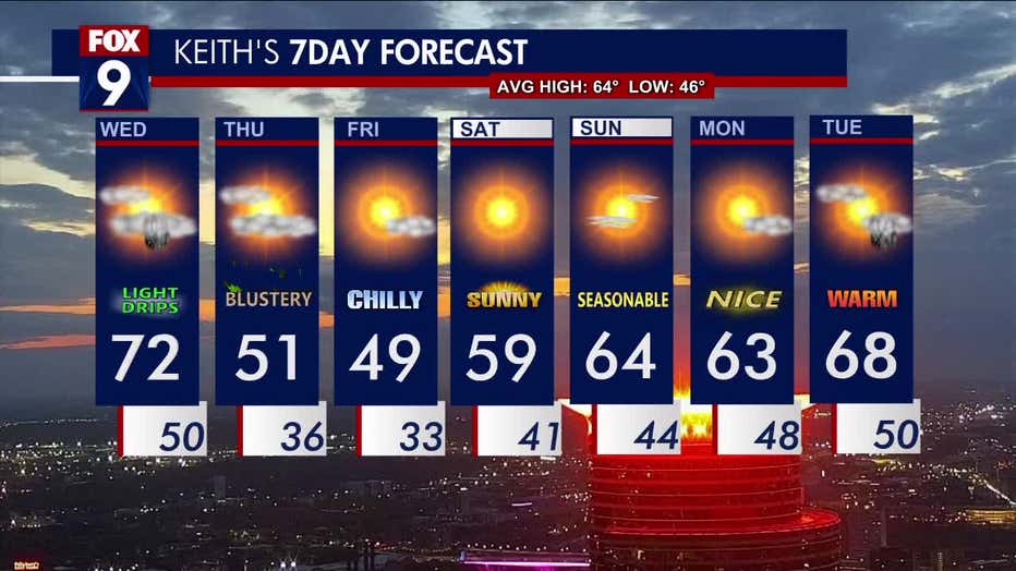
The seven-day forecast.