

Minnesota weather: Twin Cities in a record dry few weeks as drought quickly expands

Drought quickly expands in Minnesota
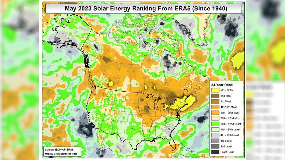
This may be a classic "be careful what you wish for" scenario. April was a mostly cool & another very wet month with plenty of sub average temperatures and gloomy conditions. This coming after the wettest winter on record and one of the wettest starts to spring on record. At this point, Minnesotans couldn't scream loud enough to get the gloom to end. Well, Mother Nature heard you and flipped the switch. May ended up anywhere from the 2nd to 5th sunniest on record, depending on where you live in the state, and the rain completely shut down after the first few days.
MINNEAPOLIS (FOX 9) - This may be a classic "be careful what you wish for" scenario. April was a mostly cool and another very wet month with plenty of sub-average temperatures and gloomy conditions. This coming after the wettest winter on record and one of the wettest starts to spring on record. At this point, Minnesotans couldn't scream loud enough to get the gloom to end.
Well, Mother Nature heard you and flipped the switch. May ended up anywhere from the second- to fifth-sunniest on record, depending on where you live in the state, and the rain completely shut down after the first few days.
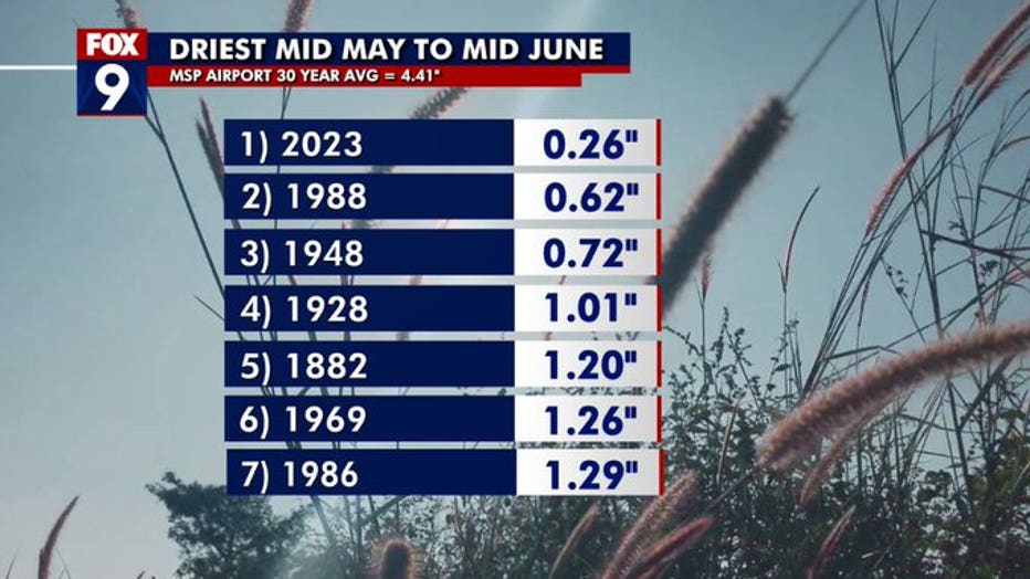
In fact, since mid-May, the Twin Cities is experiencing its driest period on record for this time of year, with most areas of Minnesota experiencing their top three driest. The Twin Cities has recorded just a little over a quarter inch of rain since May 15, which is absurdly low since this is typically the wettest time of the year on average. We average nearly 4.5 inches of rain during these four weeks — and there's really no end in sight.
RELATED: Minnesota weather: Air quality alert continues Thursday
It was the wettest winter on record in the Twin Cities, and we continued that very wet streak through March and April. Check out each regional climate zone's precipitation rank from Jan. 1 through May 14:
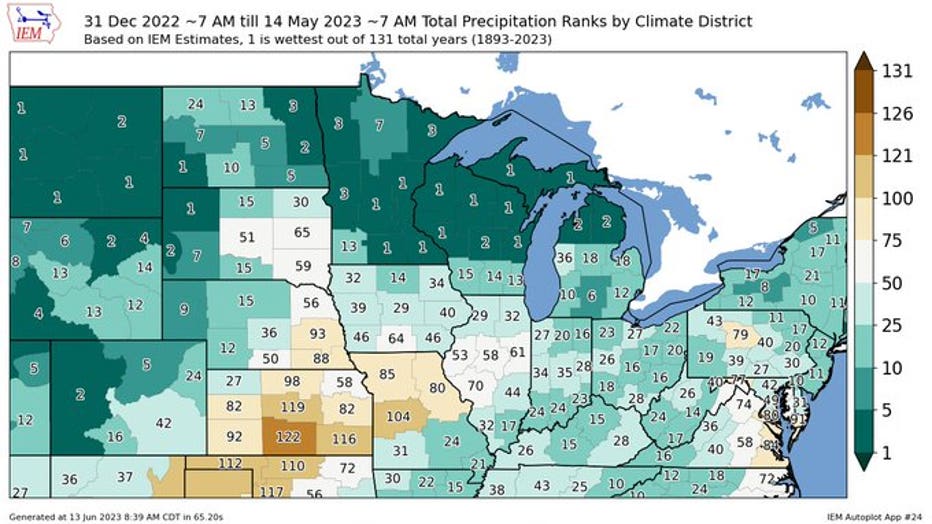
Any region that is dark green with the No. 1 labeled over it indicates the region experienced its wettest on record for the first four-plus months of the year. That includes much of the state and several spots in the region, which just proves that our wet pattern got stuck for several months. But now things have changed. Since mid-May, many areas have now seen some of the driest on record for this time of year.
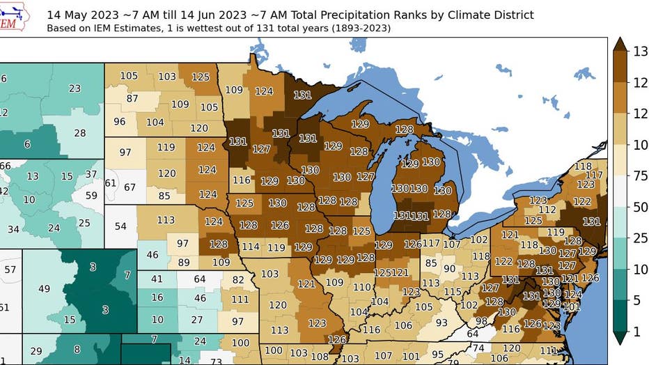
Any region that is dark brown with No. 131 labeled over it indicates the region is experiencing the driest on record for this time of year. The No. 131 is used because there are 131 years of record and this is the 131st wettest year — aka the driest year on record. And because of that, drought conditions are quickly expanding, especially in areas along and north of Interstate 94 that haven't had any significant rain since April. Parts of southern Minnesota did get some heavy rain in the first few days of May helping to prevent the spread of drought for now.
So when will we get some significant moisture? Well, it could be a long way off.
The Upper Midwest has been stuck in split flow over the last few weeks. You can see that on the first image above. Split flow refers to the two jet streams (the blue arrowed lines) splitting away from each other in the central U.S. This forces any storm system to move into the West Coast and then either move northward into Canada or southward toward the Gulf of Mexico, leaving much of the Central U.S. out of the rainfall. Well, if you refer to the following two images, not much changes with the jet streams (the steering currents in the atmosphere) staying out of Minnesota.
The biggest change may happen toward the end of next week as a ridge of high pressure builds in the East with the jet streams potentially surging northward well into Canada. This will allow heat and humidity to build in the eastern two thirds of the country and could lead to the first big heat wave of the season for many areas along and east of the Mississippi River, including Minnesota.