

Minnesota weather: 'Life-threatening' conditions, emergency declared

Winter road conditions remain icy
Wind and snow are creating treacherous snow conditions on many roads throughout Minnesota Friday evening. FOX 9’s Theo Keith has the latest.
MINNEAPOLIS (FOX 9) - Blizzard-like conditions continue Friday, which could make travel difficult or impossible across much of southern Minnesota and beyond.
What to expect in the Twin Cities
![Minnesota road conditions amid blizzard-like conditions [8:30 a.m. update]](https://static-media.fox.com/fmcv3/prod/fts/A-787151/iksmap44110vbmuv.jpg)
Minnesota road conditions amid blizzard-like conditions [8:30 a.m. update]
FOX 9's Hannah Flood takes a look at road conditions around Minnesota at 8:30 a.m. Friday. Much of the area is under a winter weather warning or blizzard warning until 6 a.m. Saturday due to blowing and drifting snow.
- Friday: It'll be bright and frigid, with wind gusts up to 40 mph. This will lead to severe blowing snow across the region. A high of 2 below and windchill around 25 below.
- Friday night: Gusty breezes will lead to more blowing snow. It'll still be very cold, with a low of around 6 below and a windchill of around 35 below.
- Saturday morning: Conditions slowly improve with winds gradually diminishing. It'll still be cold, with a high of 3 degrees and a windchill of around 15 below.

Holiday travel rush continues at MSP
Many Minnesotans are braving the recent winter storm to travel for the holidays. FOX 9’s Paul Blume has the latest from Minneapolis-St. Paul Airport.
RELATED: These are the all-time coldest temperatures ever recorded in each state
Conditions are worse in southern Minnesota
In southern Minnesota, conditions are expected to be worse. Blowing snow could make travel treacherous at times due to whiteout conditions and snowdrifts on the roadways — especially Friday afternoon and evening.
The Minnesota Department of Transportation's (MnDOT) website shows roads are closed for a large area of southern Minnesota, while travel is not advised for much of western Minnesota due to blowing and drifting snow. This includes much of the blizzard warning area.
State highways in the following Minnesota counties remain closed as of 6:30 p.m. on Friday:
- Chippewa
- Kandiyohi (portions south and west of Willmar)
- Lac qui Parle
- Lincoln
- Lyon
- Murray
- Pipestone
- Redwood
- Renville
- Yellow Medicine
Meanwhile, some counties, including Blue Earth, Pope, Wilkin and Kandiyohi, have pulled plows from the roads due to low visibility.
Interstate 90 from the South Dakota border to Albert Lea will close to traffic again at 4 p.m. on Friday due to blizzard conditions creating blowing and drifting snow with zero visibility. I-90 was temporarily reopened to traffic earlier this morning, according to MnDot
Blizzard warning expires at 6 a.m. Saturday
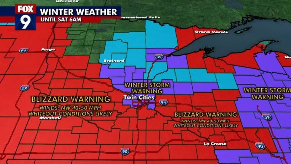
A blizzard warning is in effect for much of Minnesota until 6 a.m. on Saturday. (FOX 9)
The current blizzard warning is in effect until 6 a.m. Saturday for an area that is basically along Interstate 94 and points southward, except the heart of the Twin Cities, which is under a winter storm warning.
RELATED: Winter safety driving tips if your car winds up in ditch
When the weather alerts expire, conditions won't instantly change — they'll gradually improve throughout the day.
Walz declares emergency
Friday evening Governor Tim Walz declared a peacetime emergency, providing National Guard assistance to stranded motorists in Southwestern Minnesota.
"Every Minnesotan deserves a safe holiday, and the Minnesota National Guard will help stranded motorists and ensure everyone can travel safely," said Walz i na statement. "I am incredibly grateful that the National Guard has answered this call to action, and I’m confident that they have the right personnel and resources for this mission."
The Renville County Sheriff’s Department requested that the Minnesota National Guard assist with the rescue of stranded motorists and provide local armories as emergency shelters.
Warm-up next week

The seven-day forecast, as of Friday morning. (FOX 9)
The frigid weather won't last forever — and a thaw is in our future. The high on Sunday will be around 7 degrees in the Twin Cities, and it'll gradually warm up from there.
Monday's high is forecast to be 11 degrees in the Twin Cities. Tuesday's high will be around 22 and degrees, and Wednesday and Thursday could see highs above freezing, in the mid-30s.