

Minnesota weather: Wind gusts reached 70+ mph overnight into Wednesday
MN weather: More severe storms possible Wednesday
Overnight storms are clearing Wednesday morning, but another round of strong to severe thunderstorms is possible in the afternoon and evening. These storms carry a threat of large hail, damaging winds, and tornadoes. FOX 9 meteorologist Cody Matz has the forecast.
(FOX 9) - A round of storms that moved across Minnesota overnight developed wind gusts that caused damage in several areas and knocked out power for thousands.
Minnesota storm wind gusts
What we know:
FOX 9’s meteorologists worked through the overnight hours to provide updated information to keep viewers sky aware into Wednesday morning.
Storms in the early morning hours produced strong wind gusts across the state, especially in western Minnesota.
A few areas reported gusts over 70 mph, with the strongest wind gusts reported near Madison, Minnesota, with one report just west of town of 83 mph.
Another at the Madison-Lac Qui Parle County Airport was reported to reach 78 mph.
Just over the board in South Dakota, gusts were reported at 90 mph.

MN weather: Ian Leonard tracks overnight severe weather
FOX 9 Meteorologist Ian Leonard is tracking severe storms rolling into Minnesota overnight. The Twin Cities metro is under a Severe Thunderstorm Watch until 7 a.m.
Downed trees, damage and lost power
Dig deeper:
Closer to the Twin Cities, several large trees were seen uprooted, with reports of damaged homes and vehicles.
The storms also left thousands of customers across the state without power.
As of 5:20 a.m. on Wednesday, approximately 590 outages were affecting over 54,000 Xcel Energy customers statewide, according to the company’s website.
The company said crews were prepared to respond to outages and would prioritize the largest outages first to restore power to the greatest number of customers as quickly as possible.
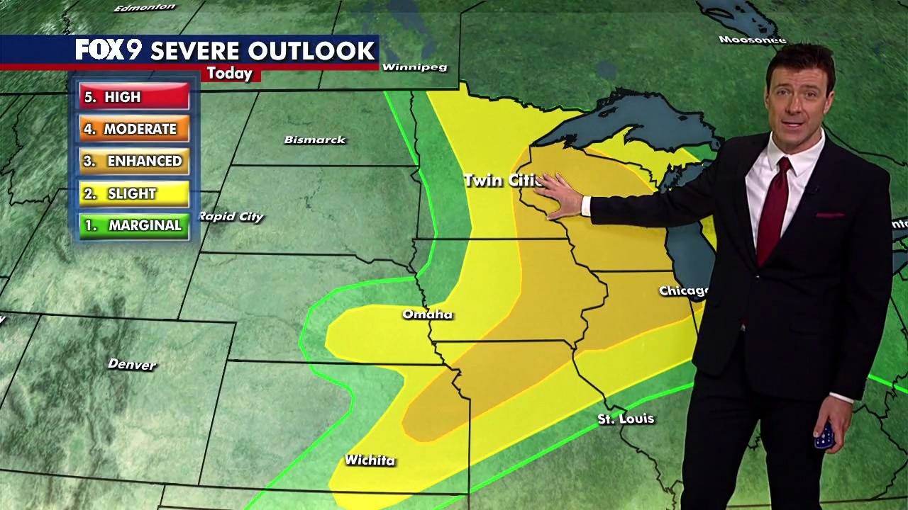
Wednesday storms ahead
What's next:
Another round of severe weather is possible Wednesday afternoon and evening.
Eastern Minnesota and western Wisconsin face a level 3 enhanced risk of severe weather, extending into eastern Iowa and northern Illinois. Central Minnesota remains under a level 2 slight risk, while western Minnesota is under a level 1 marginal risk.
The latest round of storms could develop between 11 a.m. and 7 p.m. Wednesday. All severe weather hazards are possible, including baseball-size hail, damaging winds, and tornadoes.

(FOX 9)