

Minnesota weather: Our pleasant stretch of weather has no end in sight

Friday's forecast: Sunny and pleasant!
High in the 70s through most of the day. Saturday could see scattered light rain with highs in the upper 60s.
(FOX 9) - Hope you've enjoyed the weather for the last couple of days because we are about to get a lot more of it.
Our weather pattern is about to get "stuck," which means conditions are unlikely to change across much of the country over the next several days. While that can spell a heat wave, drought, or even flooding rains … this time around that just spells; P-L-E-A-S-A-N-T.
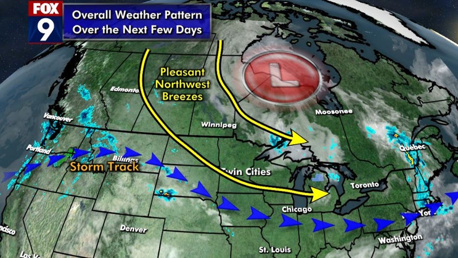
Pleasant weather pattern for Minnesota. (FOX 9)
The strong storm system that brought us the severe weather over the Memorial Day weekend continues to influence our weather, but in a much more positive way. That low pushed toward the Hudson Bay in Canada, fanned out, and is now casually spinning in northeastern Canada. This is leading to a stagnant weather pattern across North America with generally cool and cloudier conditions in eastern Canada, heat building in the South and Southwest, and the Upper Midwest stuck in between. But that places us generally in the "Goldilocks" zone as temperatures will be wonderfully comfortable until this pattern breaks.
So when does that happen? Well, no way to know for sure … but it does appear as if it could easily be a week before that happens. Not only does the overall temperature profile not move much for a while, as seen in the tweet above, but "longer range" guidance suggests it could be a couple of weeks. Check out this dot and whisker plot from one of the global computer forecasting models.
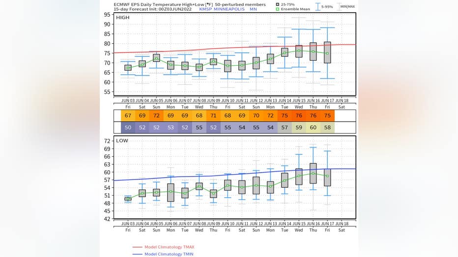
Dot and whisker plot from global forecasting models, which shows the probability for forecast high and low temps. (FOX 9)
A dot and whisker plot shows the probability for forecast high and low temps. The dot and green line on these graphs show the median temperature for that day on the computer model. That is also the numbers you see indicated in the rows on the bottom of the image — both for the high and low for each day. Then you have the middle 50% of probable solutions in the gray box, meaning more often than not, the high (or low) temperature ends up in the gray box. Then you have the "wild card" temps, the extremes if you will. That's where the "whiskers" come in. Those blue lines indicate 45% of the remaining 50% of all probable temperature solutions for that day. So the closer the lines are together, the smaller the possible range in temperatures for that day. The natural trend for a computer model is that the farther into the future you go, the larger the distance in the whiskers of this plot. It's not unusual that on day seven of the forecast, there is a 30-degree spread in forecasted temperatures by this plot.
Well, if you take a close look at the picture above, the thing that stands out for me is the whiskers on this plot stay relatively close together until the last couple of days, roughly two weeks away. That means there is a high probability for fairly accurate temps because of our fairly stagnant pattern. So, while it's not a guarantee, there is an above-average likelihood that temps will hold pretty steady for a while.
For those who have followed, I was recently discussing a higher likelihood that it could be another hot and dry summer — feel free to familiarize yourself with the story here.
So does this mean we now won't have a hot and dry summer? No, it does not. We have a LONG way to go as we are just in the infancy of the hot season here in Minnesota and much of the country. The pattern can certainly change for the warmer … and long-range models are indicating the second half of June has the potential to be significantly warmer than the first half.
So for those longing for the summer heat, just sit back and enjoy the pleasant weather because the persistent heat will be here before you know it.

Minnesota weather: Gorgeous day with a high of 70 Friday
Looking ahead, showers are possible in southern Minnesota Saturday morning, and a couple of sprinkles are possible Sunday evening. We're back to a clearing trend next week, with highs in the upper 60s and 70s for much of the week.