

The polar vortex is the reason why this winter has been mild
MINNEAPOLIS (FOX 9) - The term “polar vortex” became an everyday term amongst the masses back in the winter of 2013-2014 when much of the United States was locked in a grip of a cold outbreak we hadn’t seen in decades. Suddenly, this term was associated with anything and everything cold in the Lower 48, especially in the winter.
But, it’s this same polar vortex that can lead to very mild conditions as well. Those same mild conditions that much of the country has experienced this winter.
The polar vortex is essentially a river of air miles above the ground in the polar regions that is a direct result of the Earth’s constant rotation. The size, shape and strength of this river can determine where the coldest air in the Northern Hemisphere is located. Often times when the polar vortex is strong, very cold artic air gets bottled up in the Arctic regions of Alaska, northern Canada and the North Pole. This can lead to very mild conditions across the Lower 48. But when the vortex weakens and breaks down so to speak, this can allow that very cold arctic air a window to flow through and push southward into the U.S.
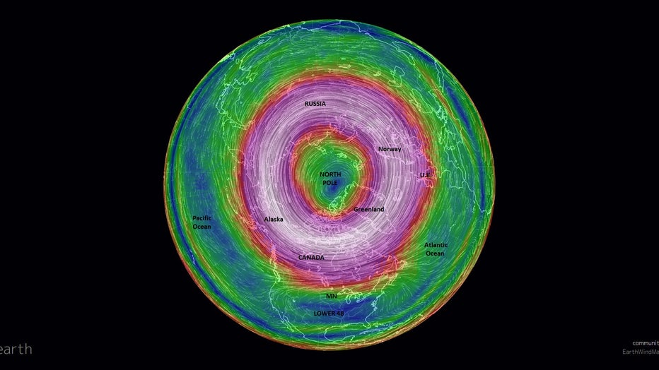
A look at wind speeds at the very top of the Northern Hemisphere. These winds are miles above our heads at the very edge of our atmosphere and are referred to as the polar vortex
The strength of the Polar Vortex is measured indirectly and charted into an index called the Arctic Oscillation (AO). This is a graph based off overall surface pressure across the top of the world. While it’s not a direct measurement, the atmosphere is interconnected from the ground all the way to the top. So subtle changes can have a cascading effect on the overall system. Therefore, changes in the polar vortex located miles above the ground can and often does lead to at least subtle changes in surface pressure that is detected in the AO. When the index is positive, the polar vortex is stronger, leading to the overall containment of arctic air around the North Pole and often leading the mid-latitudes, like us here in Minnesota, warmer than average. When the index is negative though, it’s the exact opposite. The polar vortex is weaker leaving a much weaker barrier around that cold air to keep it contained. This can lead to the cold air spilling southward toward the U.S.
This past weekend, the polar vortex was strong enough that the AO hit a record high, which you can view in the chart below.
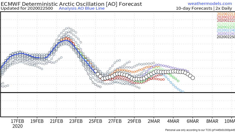
This is the Arctic Oscillation chart that shows the overall index for surface pressure in the Arctic region. The higher the index, the stronger the polar vortex. The blue line indicates the observed strength of the index, while the other colored and
This is the second time this month that the index has passed 6, something that had never been seen before since records began more than 50 years ago. This indicates that the polar vortex is super strong, not allowing cold air southward. There’s no better example of this than what has been happening in northern Alaska the last several weeks. After a record warm 2019, 2020 has started with a cold stretch of weather that hasn’t been seen in decades. In the city formerly named Barrow, right along the Arctic Ocean, they managed to stay colder than minus 15 degrees for 25 consecutive days.
The strong polar vortex is likely to blame for this. Not to mention, the warmth in the Lower 48. While it’s been mild here, it has been one of the warmest winters on record for much of the East Coast.
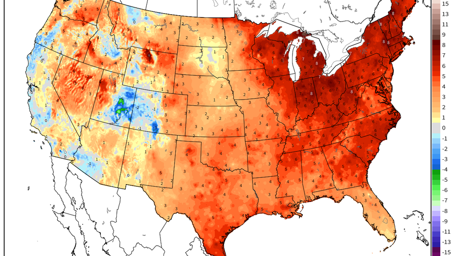
The average temperatures found nationwide for the month of January.
There are dozens of large-scale variables that come into play when determining how our seasonal temperatures will play out. The Polar Vortex and Arctic Oscillation are just 2, you can include 4 other major oscillations, plus the possible presence of El Nino and La Nina to name a few. This is why we haven’t seen record warmth in Minnesota… that and our near normal snowfall so far has led to a warmer than normal, but not super warm Minnesota winter.
So what does the spring have in store? Good question! IF the polar vortex stays strong through March and April as the forecast would suggest, then it’s a good possibility that Minnesota is near or above average in temperature as well. That said, our spring months have been trending colder and snowier over the last several years, so I guess we’ll have to wait and see.