

Minnesota weather: Snow, wind and dangerous cold will take us into Christmas

Wednesday's forecast: Snow Wednesday, blizzard or blizzard-like conditions to follow
Snow will arrive in the Twin Cities in the late morning. Strong winds on Thursday will blow snow around, creating blizzard or blizzard-like conditions across the area. Temperatures will be subzero.
MINNEAPOLIS (FOX 9) - Snow, wind and cold — three things we know a LOT about here in Minnesota. But even by our standards, the lead-up to our Christmas weekend will likely be pretty brutal.
RELATED: Minnesota weather: Timeline of what to expect with blizzard-like conditions
Now, nothing we are about to experience will be groundbreaking. Quite likely we don't break a single record, either with the cold, the wind, or the snow accumulation. However, the length, scope and timing of this storm are really what makes this storm different.
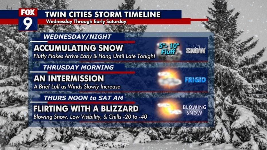
The timeline for the two-part storm. First, accumulating snow arrives Wednesday morning and will hang through the evening with 5-10 inches of fluffy snow possible. Then there will be a break with clearing Thursday morning. Then part two ramps up Thur
When many of us drive south in the winter, which includes the holidays, conditions often improve drastically as you get into the Interstate 80 and Interstate 70 corridors. That will not be the case this year for much of Thursday, Friday and Saturday as snow, gusty winds, and very cold temperatures will encompass much of the eastern three-quarters of the country. Subzero wind chills could get all the way to the Gulf of Mexico with a flash freeze for many areas in the south and east that just aren't prepared for temperatures that cold.
This could lead to significant travel disruptions at times for more than 40 states between now and Christmas. Here's how the next few days are likely to unfold (click to view the gallery below).
While some of us will be heading to the airport, the vast majority of those traveling more than 100 miles from home will go by car. In the Midwest and Great Lakes, the travel issues will start from west to east. It will start in the western High Plains Wednesday as snow spreads across Wyoming and the Dakotas early, followed by Minnesota, Wisconsin and Iowa. Then the snow moves south and the big drop in temps follows, encompassing most areas west of Interstate 35 by Thursday afternoon. It continues eastward from there later Thursday into Friday.
It's this Thursday/Friday timeframe (click to view the gallery above) that will likely see the most impactful conditions in Minnesota and all neighboring areas with strong gusty winds and very cold temperatures leading to dangerous wind chills and blizzard or near-blizzard conditions in many areas.
Check out just how strong the winds could be:
This all slowly wraps up on Saturday from west to east with the worst conditions hanging around into late Christmas Eve for areas east of I-35.
In an "average" snowstorm, if you spin out or get stuck somewhere and conditions aren't instantly life-threatening. But that is just not the case this time around. If you run into some issues, even in urban areas in the lead-up to Christmas, it could become life-threatening very quickly with wind chills so low and frostbite times dropping to 10 minutes or less. This means if you spend any unplanned extra time exposed to the elements, you can get in trouble quickly.
Check out the drop in temperatures and wind chills behind this arctic front roll from west to east across the central U.S.: