

Minnesota weather: Not as brutally cold Wednesday; flurries possible Thursday

MN weather: Not as brutally cold
It won't be as brutally cold on Wednesday, and there are flurries possible on Thursday. FOX 9's Cody Matz has your forecast.
MINNEAPOLIS (FOX 9) - Wednesday will feel much better than it has the past few days, thanks to less of a breeze.
Wednesday will be the warmest day we've seen in a few days, with a high of around 12 degrees in the Twin Cities metro. The wind chill advisory has expired for the Twin Cities but remains in effect for northeastern and southwestern Minnesota on Wednesday morning. The wind chill has improved over the past 24 hours, and will generally be a few degrees shy of zero on Wednesday afternoon.
Meanwhile, the sun will shine a bit on Wednesday, though there will still be a few clouds.
Flurry possible in Twin Cities Thursday
Cloud cover will increase on Thursday, especially across southwestern Minnesota. Light snow is possible in southwestern Minnesota totaling maybe a half-inch to an inch, while the Twin Cities metro may see a flurry.
RELATED: Winter events in Minnesota: What's still on, canceled and postponed
The high on Thursday will be around 10 degrees in the Twin Cities.
This system will drag in slightly colder air on Friday. There will be a breeze out of the north on Friday, with temperatures falling a few degrees. The high on Friday will be around 7 degrees in the Twin Cities.
Temperatures climb this weekend
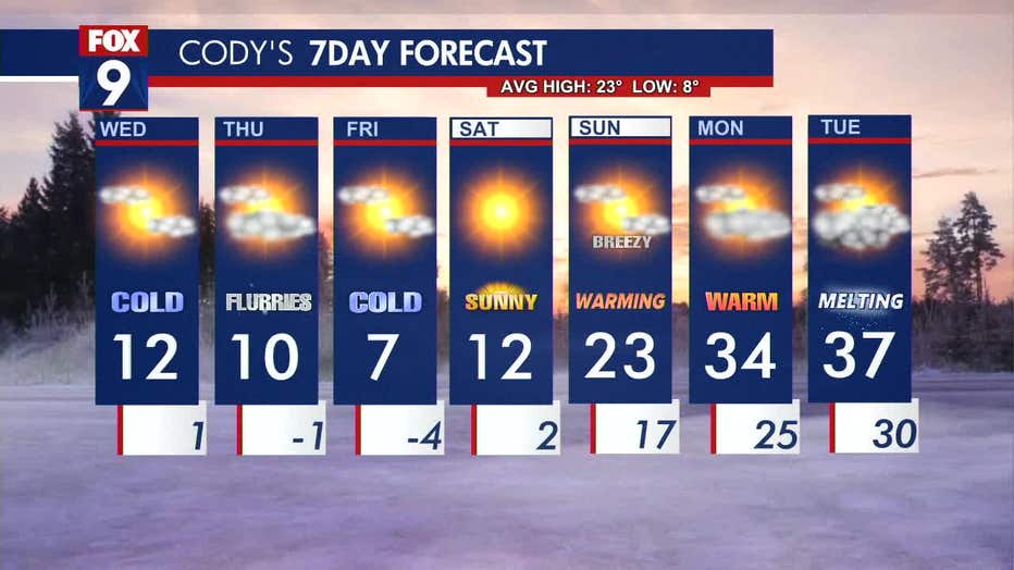
After Friday, it'll start to warm up again. Saturday will feature sunshine and a high of around 12 degrees. Then Sunday, temperatures will climb into the 20s. Though it'll be breezy.
Temperatures above freezing are expected on Monday and Tuesday of next week.