

Minnesota weather: Light snow and chilly temperatures

Saturday forecast: Cold and breezy with possible flurries
There will be some lingering flurries Saturday morning, but they should clear out of the Twin Cities metro by the afternoon. The high will be 20 degrees with feels like temps in the single digits.
(FOX 9) - After several days of snow, light flurries will linger through Saturday morning but should clear out of the metro for the weekend.
Several parts of the metro woke up to another light layer of flurries following the heavy wet snow left by the multi-day storm system. The good news is the precipitation should finally move out after the morning hours.
Several regions received a large amount of snow from the messy storm system, especially in the arrowhead region. Some of the highest snowfall totals include 30.5 inches in Rice Lake, Duluth with 20.8 inches, and Hermantown with 26.5 inches of snow.
Parts of the arrowhead and southwestern Minnesota are still under a winter weather advisory for additional snowfall and blowing winds.
The metro saw considerably less snow than the northern part of Minnesota. There's a wide variety of snowfall accumulation, with Edina only getting 2.2 inches of snow, while Chanhassen got 5.6 inches of snow. Take a look at some Friday morning snow totals around the Twin Cities:

Snow totals as of Friday morning in the metro
While the snow clears out, the colder temperatures will move in. Sunday will be cloudy and a high of 20 degrees with feels like temperatures in the single digits or even below freezing. The roads were slick with several icy spots on Saturday morning, so drive carefully.
Sunday will be even colder, with a high of 15 degrees and a low of 3 degrees. Looking ahead at the week, the frigid air will move in with highs in the single digits and lows below freezing.
The average for this time of year is around 28 degrees, with lows around 15 degrees.
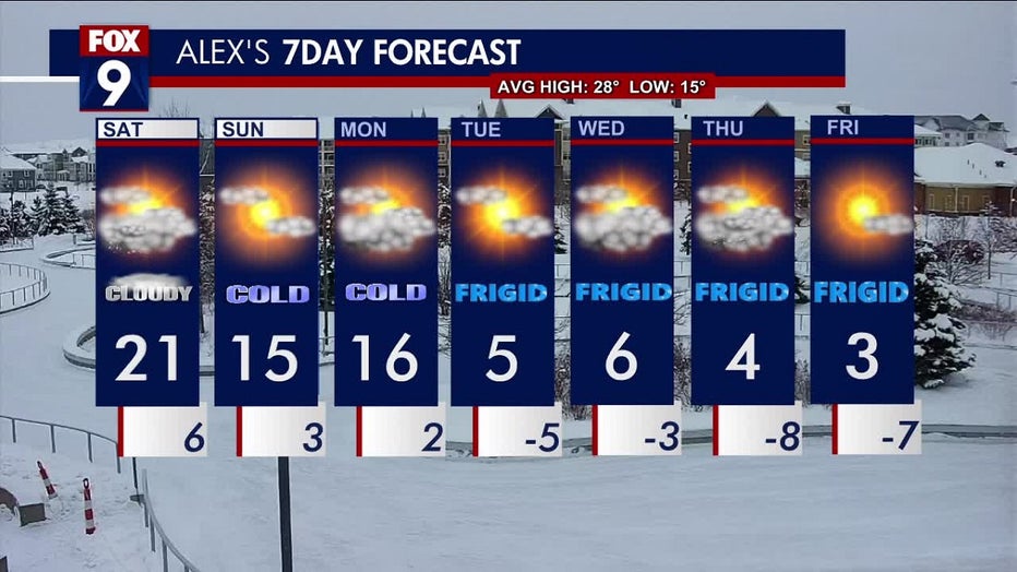
Take a look at your 7-day forecast