

Minnesota weather: Cold on Christmas Day with possible snow

Sunday forecast: Snow possible on Christmas Day
Parts of the metro and southwestern Minnesota could see some accumulating snow throughout the day on Sunday. Temperatures will remain well below average with a high of 6 degrees and feels like temperatures below zero.
(FOX 9) - Christmas Day will be a cold winter wonderland with chances of accumulating snow in southwestern and central Minnesota.
The entire state is under a wind chill advisory on Sunday, with the feels like temperatures staying around -25 to -35 degrees but still warmer compared to Saturday. Frostbite can happen on exposed skin in as little as 10 minutes, so be mindful and bundle up when outdoors.
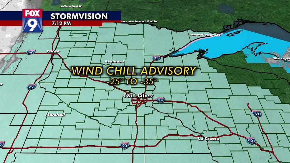
The entire state of Minnesota is under a wind chill advisory, with temperatures feeling like -25 to -35 degrees
Sunday will start sunny and cold for most of the state, but the cloud cover will increase throughout the afternoon as the snow moves into central and southwestern Minnesota. The high on Sunday will reach 6 degrees in the Twin Cities but still feel well below zero.
A winter weather advisory will go into effect around noon for Brown, Chippewa, Redwood, and Renville counties. The snow is expected to arrive in southwestern Minnesota around lunchtime, and the region could see anywhere from 1-4 inches of accumulation.
The light snow will work its way toward the metro around dinner time and could bring 1-2 inches of accumulation. The snow will be light, so blowing snow could reduce visibility on the roads. Keep your eyes up and drive carefully, as there might be slick spots.
Looking ahead, the weather looks much nicer as temperatures take a dramatic turn. Monday will still be cold and below average, with a high of around 11 degrees and wind chills making it feel like -5 degrees. By mid-week, temperatures will be above average in the mid-30s and hang around until the holiday weekend.
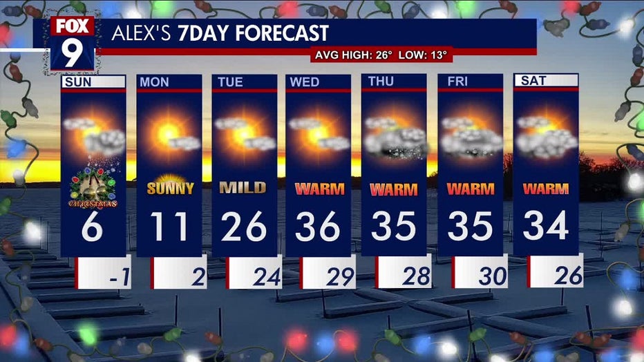
Take a look at your 7-day forecast