

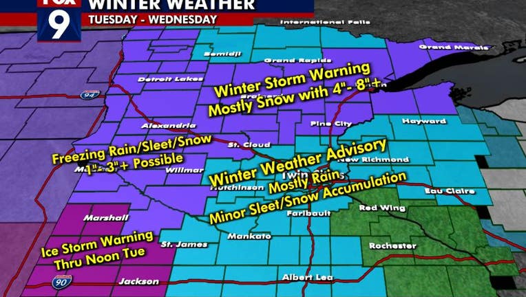
It's December, so why isn't our storm all snow?
A 2-phase storm is rolling into Minnesota Tuesday. (FOX 9)
(FOX 9) - A 2-phase storm system is rolling across the central U.S. this week, with phase 1 occurring on Tuesday and Wednesday. The second phase is expected Thursday and Friday. This first phase includes a LOT of moisture and some relative warmth as much of the state will have more than 1 type of precipitation during this time period. This is because we will have a HUGE influx of relatively warm air and plenty moisture surging northward from the Gulf of Mexico.
Yes, even in the winter, a large chunk of the moisture here in Minnesota comes from the Gulf of Mexico.
Most of the time though, there is enough cold air near the ground to help keep our precipitation all solid. But this time, the surge of warmth and humidity is so strong that it will completely overwhelm our chilly temperatures, forcing the thermometer to rise, leading to widespread liquid precipitation. This is very evident looking at our low level jet (LLJ).

Minnesota weather update: Tracking winter weather across state
Ian Leonard is tracking a winter storm that is bringing a wide-array of weather conditions across the state.
The low-level jet refers to a zone of the atmosphere roughly five thousand feet above ground level that can harbor a river-like stream traveling 40-80 mph that transports relative warm air and moisture straight from the Gulf of Mexico. You can see that in the image above with the colors indicating wind speed and the black arrow indicating wind direction. This pulls in copious amount of moisture straight to the Upper Midwest essentially overloading the air with water, which then forces temperatures at that level to rise above freezing. Combine that with gusty southeast winds here at ground level that also forces the temperature to rise, and you have the stage set for more liquid than white.
However, in most cases it's not that "cut and dry". The atmosphere is extremely complex with hundreds of variables, most of which just can't be seen or measured. Because of this, while rain is likely going to be the predominate precipitation type in the Twin Cities, there will still likely be pockets that manage to stay near or below freezing, leading to patchy occasional sleet pellets or flakes.
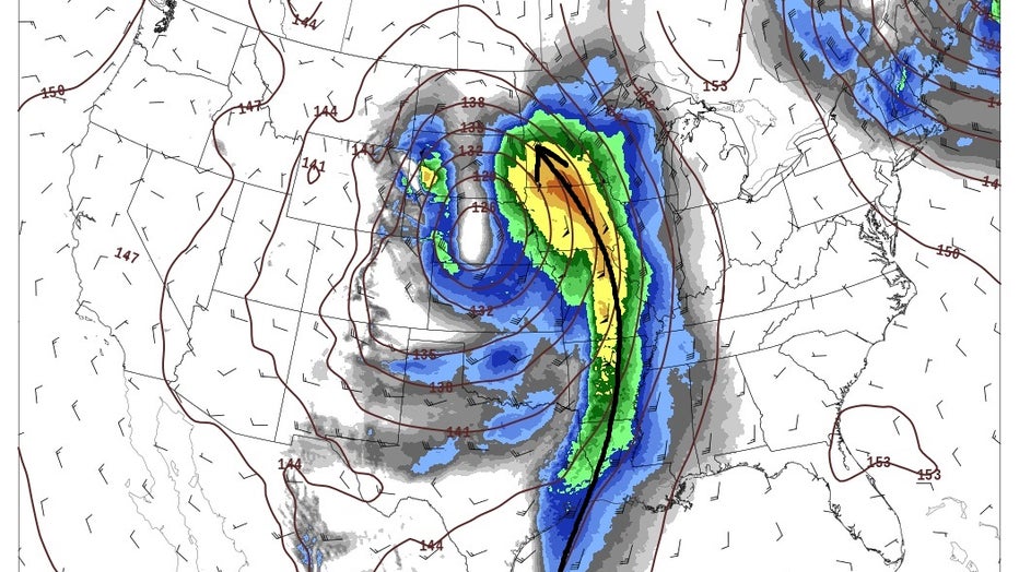
Low Level Jet bringing warm air up from the Gulf of Mexico. (FOX 9)
For example, you can actually increase moisture levels enough to where you overload it and force the atmosphere to cool. You likely know this process as evaporational cooling…what some folks have in their homes to cool them off in the summer.
In the weather world, this specific process is known as precipitation loading. This can lead to splotchy areas of heavy snow in between areas of moderate to heavy rain. That can lead to very sparse and splotchy snow accumulation of a couple inches or more. This is all occurring in between wide swaths of only rainfall. That can make driving down the road very interesting with moderate rain one minute and heavy snow the next.
While this is unlikely to occur in the Twin Cities Tuesday, it is a small possibility. More than likely though it will be rain, with some interspersed flakes and sleet pellets. So why can't the atmosphere just commit to one or the other? Well, because temperatures are THAT close to freezing.
Here is a profile of the atmosphere as meteorologists view it.

A profile of the atmosphere as viewed by meteorologists. (FOX 9)
Yes, it's essentially a foreign language, but let me point out a couple of things to focus on:
First, think of this as a profile of an object. So, imagine standing back to look at the wall of your bedroom. The part of the wall near the ceiling is the top of the atmosphere and the part of the wall near the floor is the bottom of the atmosphere, also known as ground level. The red line shows the temperature at each level of the atmosphere as you climb in elevation. The green line works the same way, but for dew point instead. The straight bold black line indicates where the freezing mark is located. So, anytime that red line (and green line in this case) is to the left of the straight solid black line, the temperature at that height is sub-freezing. But notice the red and green line are essentially overlaid on that straight black line for maybe 20% of this image. That means that for roughly one fifth of the atmosphere, the temperature is near freezing. This can lead to small sporadic melting as a snowflake falls through the atmosphere depending on whether the temperature is just above or just below the freeze mark. Because of this, there is just no way to know for sure how much of that snowflake has melted. Quite likely, it was enough to melt it entirely to give us rain, but that's just not always the case, and isn't always consistent going from one location to another. So this is why we have to forecast a "rainy mix".
For those snow lovers though, while phase one of this two-part storm will likely be mostly liquid for the Twin Cities, phase two should be mostly or all snow. The overall moisture content of the atmosphere will be far lower, so heavy snow is not likely. However, we do have a chance for at least minor accumulating snow Thursday & Friday. Stay tuned!