

6-10 inches of snow, whiteout conditions possible in 2-part winter storm Friday and Saturday
A timeline of this weekend's winter storm expected to impact much of Minnesota.
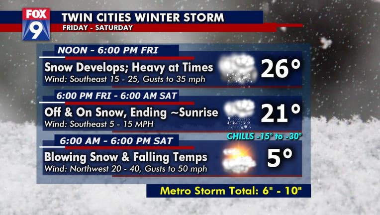
(FOX 9) - A two-part winter storm could bring between 6 and 10 inches of snow to much of Minnesota on Friday into Saturday.
The first part of the storm will be possible accumulating snow that will begin midday Friday and go through Friday night. Temperatures are expected to be in the 20s Friday night.
Parts of the I-90 corridor and northwest Minnesota could see a little less than the 6-10 inches, however. To the west, a blizzard warning warning is in effect for Minnesota counties along the North and South Dakota borders.
Once the snow wraps up early Saturday morning, a wall of wind and much colder air is expected to push through. Winds will increase with gusts up to 60 miles per hour possible in open areas.
Combined with the fresh snow, the wind could create significant blowing and drifting snow that could lead to whiteout conditions through much of the day Saturday.
Temperatures are expected to fall fast through the day Saturday with afternoon wind chills of -15 to -30 degrees possible.
Travel will be difficult Friday night and Saturday due to this weather event.
To stay updated on school closings, click here.

Minnesotans brace for incoming snow storm
The incoming snow storm could throw a wrench into some outdoor plans, but some Minnesotans are preparing to take it all in stride.