

Wildfire conditions returning to Minnesota could be a glimpse into the future
EDEN PRAIRIE, Minn. (FOX 9) - Another day, another Air Quality Alert for much of Minnesota as wildfire smoke returns to the region as it pushes southward out of Canada.
Dozens of wildfires are burning out of control across Canada, from the mountainous regions in the west, to the high forested areas in the east, and now parts of the plains in the middle. These fires are once again sending a swath of smoke into the state. The current forecast shows this low level smoke rolling south through the day Wednesday and potentially lingering through much of Thursday.
Visibility is likely to drop when the smoke is around and don't be surprised if you smell it off and on as well. While it won't be a pleasant experience, the overall "episode" should be relatively minor with unhealthy air for mostly our sensitive groups... although we could dabble with code red air quality in some cases. Air quality should drastically improve heading into Friday.
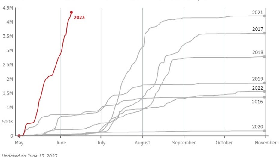
Wildfires in Canada have been burning at a record-setting pace this summer.
It's been an unprecedented fire season so far in Canada. More than 11 million acres (4.5 million hectares) have now burned, which is by far the highest number of acres on record this early in the season. In fact, it's almost 50 times higher than in an average year and only getting worse. Because of this, we will likely be dabbling with poor air quality and occasional smoke for the rest of the summer... and could extend into the fall.
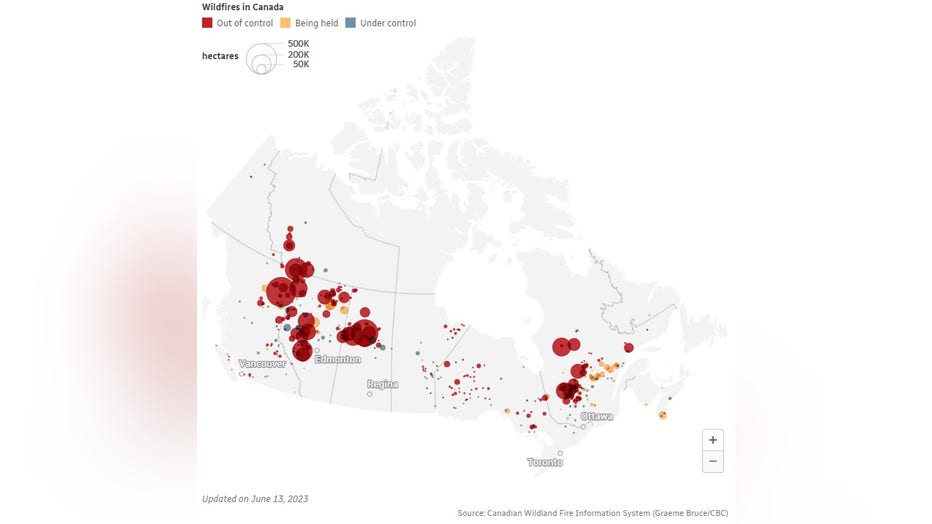
Locations of Canadian wildfires in 2023.
But this may be just a preview of what can be expected in the years and decades ahead. While overall activity can vary wildly from year to year for dozens of reasons, ocean temperatures are far more consistent...until this year. Surface temperatures of the oceans across the globe are the warmest on record…by far. While Minnesota can't get a whole lot farther from the nearest ocean, they have a huge impact on our weather globally because roughly 70% of the Earth's surface is water. Warmer ocean waters mean warmer temperatures here on land. Check out the graph showing the average sea surface temperature from around the Earth.

Ocean surface temperatures in 2023 are the warmest on record.
Since consistent satellite records began back in the 1970s, this is easily the warmest overall our oceans have been. And it's not even close with surface ocean temps coming in well above previous years for months.
While ocean temperatures in the Northern Hemisphere, including both sides of the U.S., typically peak in September, ocean temperatures as a whole usually peak in the spring because there is so much more ocean water in the Southern Hemisphere where temperatures peak in their early fall. While gradual warming of our atmosphere is expected over the next few decades, the sudden warming of our oceans has scientists and climatologists scratching their heads.
There are a few scientific reasons they're considering; transitioning to a strong El Nino, drops in shipping emissions worldwide in 2020, and the lasting effects of the Hunga Tonga volcano eruption.
But nobody really knows why this is currently happening. However, as temperatures continue climbing in the years ahead, conditions will get more and more favorable for active fire seasons thanks to the added opportunity for drought conditions to develop.