

Minnesota weather: Mostly cloudy, warm on New Year’s Eve

New Year's Eve forecast: Mostly cloudy and warm
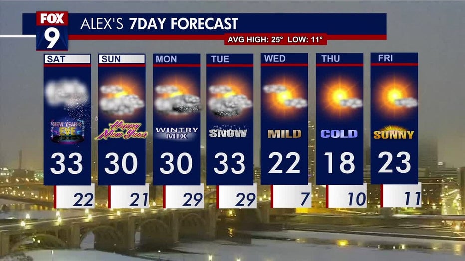
New Year's Eve will be mostly cloudy, with above-average temperatures reaching a high of 33 degrees. There could be a chance for light flurries or patchy rain in the mid to late afternoon.
(FOX 9) - The 2022 year is coming to a close on a quieter note, with above-average temperatures, mostly cloudy skies and possible flurries later in the afternoon.
It will be a misty and dreary start to the holiday weekend for most of the state. The morning will start foggy Saturday, but conditions will improve as the day continues. Minneapolis could see pockets with only 2 miles of visibility, while Alexandria with only .25 miles of visibility.
The temperatures for the holiday weekend will be above average for this time of year, thanks to a warm front moving in from the southwest. The highs in the Twin Cities metro on Saturday will reach the mid-30s and lows in the 20s.
The start of the weekend will be mostly cloudy throughout the day on Saturday, but there could be pops of sunshine. By mid to late afternoon, there's a chance of isolated flurries and a patchy wintry mix as our temperatures hover around the freezing mark.
New Year’s Day should be mild, with partly cloudy skies and a high of around 30 degrees in the Twin Cities metro. The above-average temperatures will stick around for a few days but will bring some precipitation.
Looking at the week ahead, a winter storm system is moving in, which could bring measurable snow. There’s a winter storm watch in southwestern Minnesota for Cottonwood, Jackson, Lincoln, Lyon Murray, Nobles, Pipestone, and Rock counties beginning Monday morning.
The snow should arrive in the Twin Cities on Monday, with a possibility of a wintry mix due to the temperatures hovering around freezing. The snow will stick around until Tuesday and clear out by Wednesday.
Temperatures will dip once the system moves out, but the highs will remain above zero.
Take a look at your 7-day forecast