

Minnesota weather: Record high reached on Wednesday

Minnesota weather: Record high temperatures possible
After Tuesday's first 80-degree day of the season, we're heading into the record-breaking mid-80s Wednesday afternoon with gorgeous sunshine. A gusty breeze with low humidity leads to an elevated fire danger for southern Minnesota.
MINNEAPOLIS (FOX 9) - The Twin Cities officially set a record for high temperature on Wednesday.
Temperatures climbed to 84 degrees at the Minneapolis-St. Paul International Airport on Wednesday afternoon, breaking the record for April 12. The previous record was 83 degrees, set in 1931.
Temperatures continued to climb to 85 degrees as of this writing.
The original story from Wednesday is below.
A record high is possible on Wednesday.
The morning started at 63 degrees in the Twin Cities, which is tied for the third-earliest we've ever experienced a daily low temperature above 60 degrees. And it's the warmest daily low temperature recorded this early in the season.

Twin Cities warmer than these warm climate cities today
It’s so warm, in fact, that Minneapolis will see a higher temperature today than several traditionally warm climate cities.
And the temperature will only climb from there, heading into the potentially record-breaking mid-80s Wednesday afternoon with gorgeous sunshine. The record for April 12 is 83 degrees, set in 1931.
Meanwhile, a gusty breeze with low humidity leads to an elevated fire danger for southern Minnesota.
A record heat is possible on Thursday, too, when the high in the Twin Cities could top out around 84 degrees. Late-day drips are possible on Friday, when the high will be around 79 degrees.
Then it'll be chilly this weekend. Showers are possible on Saturday, with a high in the low 50s. Sunday will be even cooler, with a high in the upper 40s.
Here's your seven-day forecast:
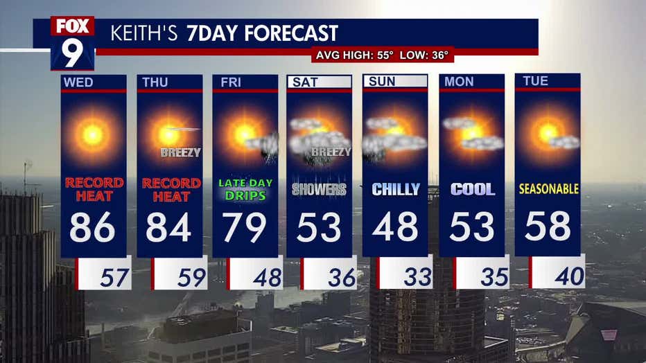
The seven-day forecast.