

Minnesota weather: Hot, humid and afternoon storms this week

Tuesday's forecast: Scattered rain throughout the day
It will stay hot and humid with more isolated storms possible Wednesday and Thursday afternoon.
MINNEAPOLIS (FOX 9) - Here comes the humidity.
After some morning showers, it'll become sunny on Tuesday through the lunch hour before isolated storms redevelop later in the day. Storms will likely fall apart once the sun sets. Hail and wind are the main severe weather threats.
Meanwhile, it'll be far more humid as we head for a summer-style pattern with highs in the upper 80s.
This pattern of heat, humidity, and stormy afternoons will continue into the weekend. Here's a look at the seven-day forecast in the Twin Cities.
Tuesday will be humid with a high of 87 degrees and afternoon storms. Another muggy day is in store on Wednesday, with a high of around 89 degrees and the chance for afternoon storms.
Thursday, which is the first day of June, could see a high of 90 degrees. The 90s continue in the forecast for Friday and Saturday. Sunday is looking humid with highs in the upper 80s.
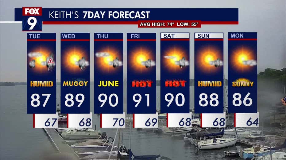
The seven-day forecast.
End of the dry streak
Rain overnight means the dry streak has officially ended. While not long in the grand scheme of the world, for this time of year, it certainly is — 11 consecutive days without rain in the Twin Cities in May (our wettest time of year on average) is tied for the fourth-longest on record and the longest since 1955.