

Blowing snow causes reduced visibility, travel woes Wednesday
(FOX 9) - The snow and wind that started Tuesday night is not making life any easier for anyone out and about Wednesday morning.

Blowing snow, falling temperatures and subzero chills on tap for Wednesday
It's a blustery little bit of our midweek with raw conditions that have been set up for the better part of the day Wednesday. But it’s not about the amount of snow, but what the wind does to it for the day today
Most of the Twin Cities metro has seen one to three inches of snow so far, with areas to the north getting a bit more. Combined with strong winds, this has created poor travel conditions with low visibility. Numerous crashes have been reported throughout the Twin Cities metro, slowing down the morning commute.
Many schools in Greater Minnesota have either a two-hour delayed start or have canceled classes entirely due to the weather. A full list of school closings can be found here.
(FOX 9)
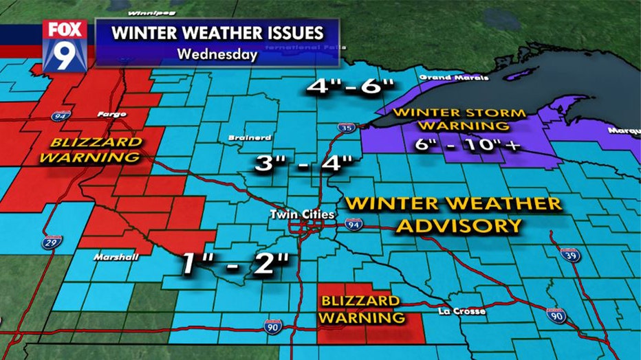
A Winter Weather Advisory remains in effect across the state until 3 p.m. The snow will taper with gusty winds, falling temperatures and subzero chills. A Blizzard Warning was in effect for western Minnesota until 9 a.m. and the southeastern part of the state until noon due to 50 mph winds and occasional whiteouts.
The snow tapers off later this morning, but blowing snow will remain an issue during the day as temperatures continue to fall. By the afternoon, temperatures will be around 8 degrees in the metro and will be below zero Wednesday night into Thursday morning. Expect wind chills from 10 degrees below zero to 20 below Wednesday night in the Twin Cities, but chills will get down to the negative 30s across western and northern Minnesota with a Wind Chill Advisory in effect for those areas Wednesday evening into Thursday morning.
Blowing snow, falling temperatures and subzero chills on tap for Wednesday
It's a blustery little bit of our midweek with raw conditions that have been set up for the better part of the day Wednesday. But it’s not about the amount of snow, but what the wind does to it for the day today
Thursday will not be any more pleasant feeling with below zero temps expected throughout the day, but at least some sunshine returns.
Snow totals through 6 a.m.
- NWS Chanhassen: 1.5 inches
- MSP Airport: 0.6 inches
- St. Cloud: 2.1 inches
- Eau Claire: 2.0 inches
Download the FOX 9 Weather App to stay up to date on the winter weather with the latest temperatures, snow totals, forecasts and school closings 24/7 customized for your current location and favorite locations: fox9.com/apps.