

Red Flag Warning issued for 29 Minnesota counties due to wildfire risk
MN weather: Scattered storms Thursday afternoon
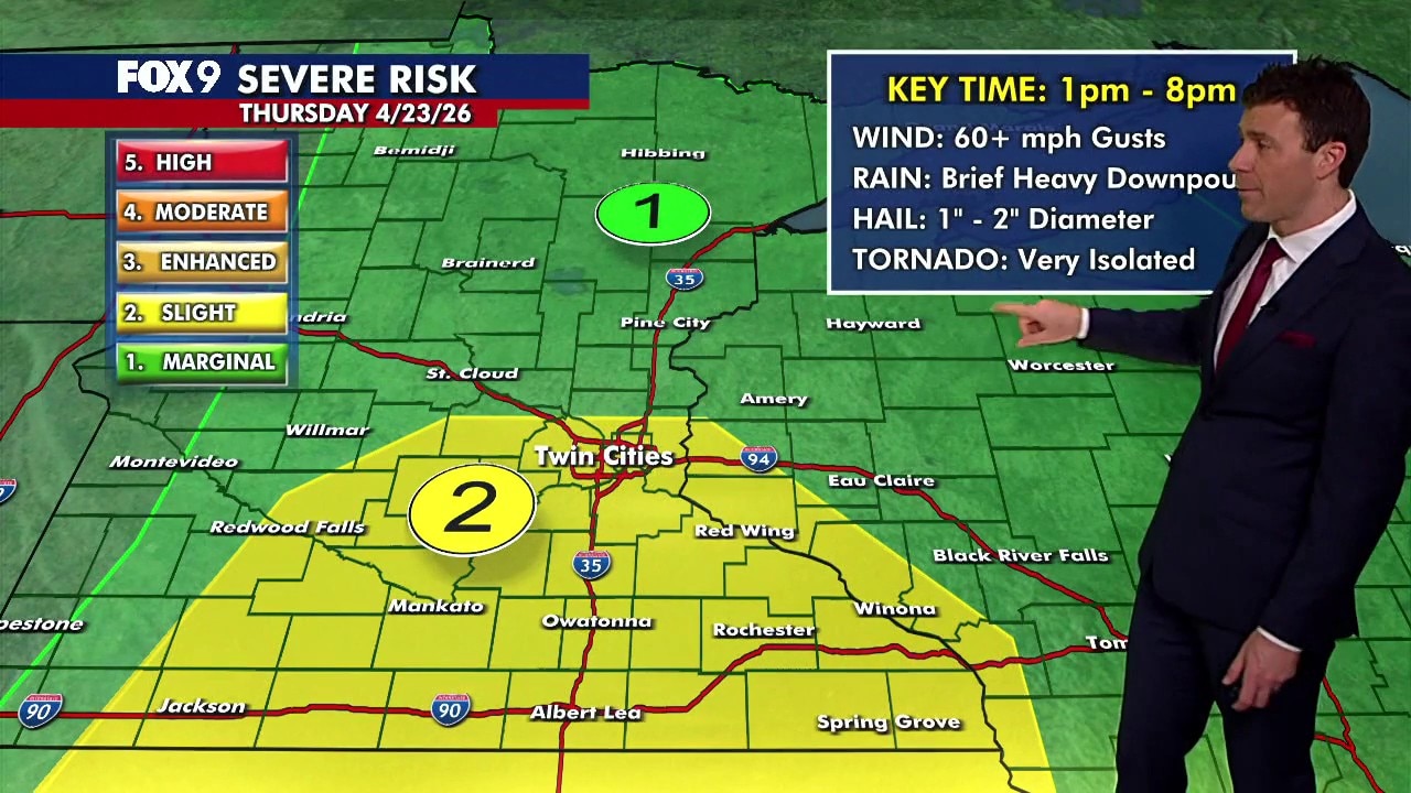
Expect a warm, humid morning ahead of scattered storms developing in the afternoon. There is a level 1 and level 2 risk of severe weather across much of Minnesota. FOX 9 meteorologist Cody Matz has the story.
(FOX 9) - A Red Flag Warning has been issued on Thursday for 29 counties across western Minnesota due to wildfire risk.
Red Flag Warning issued
What we know:
A Red Flag Warning has been issued for 29 counties in western Minnesota stretching from the Canadian border to nearly Iowa.
The counties include: Becker, Big Stone, Chippewa, Clay, Clearwater, Douglas, Grant, Kandiyohi, Kittson, Lac Qui Parle, Lincoln, Lyon, Mahnomen, Marshall, Norman, Otter Tail, Pennington, Pipestone, Polk, Pope, Red Lake, Redwood, Renville, Roseau, Stevens, Swift, Traverse, Wilkin, and Yellow Medicine.
Big picture view:
The Red Flag Warning also stretches into the Dakotas and through the Midwest and into the Southwest United States, covering parts of eastern North Dakota, South Dakota, central and western Nebraska, western Kansas, eastern Colorado, western Oklahoma, and all the way down to northwest Texas, and eastern New Mexico.
What the Red Flag Warning means
Why you should care:
The warning means weather conditions are ripe for fires to spread quickly and grow out of control. Typically, the forecast predicts dry conditions, low relative humidity and strong winds.
During Red Flag Warnings, you should avoid burning and check to ensure any recent burns have been completely extinguished.
What they're saying:
"Fine fuels, such as grass and small twigs, can dry out quickly when the relative humidity is so low and wind pick up." said Karen Harrison, DNR wildfire prevention specialist, in a provided statement. "These fine fuels can easily ignite and start a wildfire that spreads quickly."
Storms expected Thursday
What's next:
A cold front moving through will likely trigger scattered showers and thunderstorms. The best chance for storms runs from early afternoon into the evening hours.
The metro and areas to the south are under a level 2 slight risk of severe weather. Much of central and northern Minnesota is under a level 1 marginal risk. The main threats include brief heavy downpours, gusty winds over 60 mph and possible hail. An isolated tornado also can’t be ruled out.
Showers may linger into the evening, but the severe weather threat will likely diminish after sunset. Overnight lows will drop into the 40s.