Minnesota weather: Starting to cool Thursday, but staying well above average until the weekend

Minnesota weather: Temps starting to cool Thursday
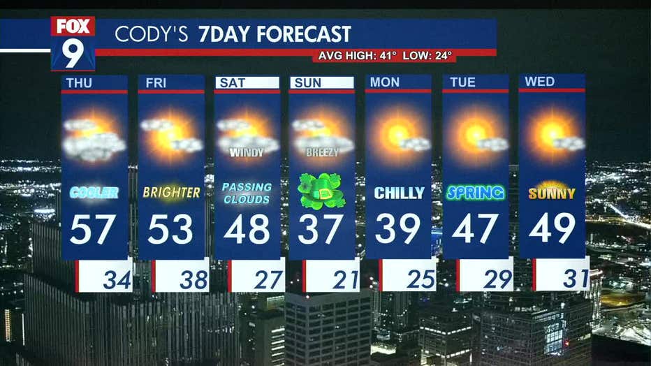
Temperatures are starting to cool, but we will stay well above average until the weekend with highs in the upper 50s for the Twin Cities metro area on Thursday.
MINNEAPOLIS (FOX 9) - After a warm few days, temperatures are starting to cool on Thursday but will remain above average until a cold front moves in for the weekend.
A northeast breeze will start the cooling trend on Thursday. The high will be a couple of degrees cooler than Wednesday, at around 57 degrees. Overnight lows will stay above freezing in the mid-30s.
A storm system mainly stays to our south, but portions of southern Minnesota could see early morning drips. On Thursday, the Twin Cities Metro area will have some morning clouds but filtered sunshine later in the day.
The passing clouds linger overnight through the morning hours and clear out for some afternoon sunshine on Friday with highs in the mid-50s.
A cold front swings in Friday night and into early Saturday morning, bringing temperatures down to the 40s degrees. Saturday will be windy, with gusts of 30 mph possible. Sunday will be chillier and still breezy with a high of around 37 degrees for the metro area.
Looking ahead, the start of the week stays mild as temperatures start slightly below average, but heat back up into the 40s for the first day of spring on Tuesday.
Here's a look at the seven-day forecast: