

Minnesota air quality alert: Twin Cities air now considered hazardous
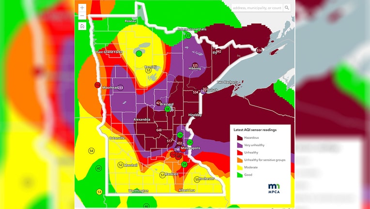
Photo from the Minnesota Pollution Control Agency website shows the Twin Cities metro area is now under a hazardous air quality alert. (Supplied)
(FOX 9) - More of Minnesota is under a hazardous air quality alert, including the Twin Cities, as wildfire smoke intensifies across the region.
QUICK LINKS: Live updates on Minnesota wildfires, smoke | Minnesota weather forecast | Download the FOX LOCAL app to get alerts | List of cancellations & delays due to wildfire smoke
Twin Cities now under hazardous air quality alert
Big picture view:
The Minnesota Pollution Control Agency said the air in the Twin Cities is now considered hazardous, meaning that residents are urge to remain inside and avoid outdoor activity.
Heavy wildfire smoke is expected to spread throughout the state Wednesday night and into Thursday morning.
State officials say, "Hourly observations have already surpassed previous records for the Twin Cities, and additional record readings are possible overnight."
Smoky air and hazy skies are can be seen across the metro area.
Air quality alert in place across Minnesota
What they're saying:
Wildfire smoke has led to the Minnesota Pollution Control Agency issuing an air quality alert for east central, central, west central, southeast, north central, north-west, and northern Minnesota.
The alert went into effect at 2 p.m. on Wednesday, July 15, and is expected to be in place until at least 11 a.m. on Friday, July 17.
State officials warn that heat will exacerbate health impacts during periods of poor air quality and that the alert could be extended for some parts of the state beyond Friday morning.
The alert sent on Wednesday shows more of the state is under a hazardous air quality alert than the alert sent on Tuesday.
Sensitive groups, such as children, older adults, pregnant women and people with underlying health issues should remain inside and avoid outdoor activity.
Local perspective:
The areas under an air quality alert include the Twin Cities metro, Brainerd, Alexandria, Hinckley, St. Cloud, Winona, Bemidji, East Grand Forks, Moorhead, International Falls, Two Harbors, Hibbing, Ely, Duluth, Roseau, and the Tribal Nations of Mille Lacs, Prairie Island, Leech Lake, White Earth, Red Lake, Grand Portage, and Fond du Lac.
Hazardous air quality, pictured as maroon in the map above, is reported in Brainerd, Hinckley, Two Harbors, Hibbing, Ely, Duluth, and the Tribal Nations of Mille Lacs, Grand Portage, and Fond du Lac. Residents in these areas are urged to remain inside and avoid any outdoor activity if possible.
Very unhealthy air quality, pictured as purple in the map above, includes Twin Cities metro area, Alexandria, St. Cloud, Bemidji, International Falls, and the Tribal Nations of Leech Lake, Red Lake, and White Earth.
Unhealthy air quality is pictured as red in the map above and includes Winona, East Grand Forks, Moorhead, Roseau, and the Tribal Nations of Prairie Island, White Earth, and Red Lake.
Why you should care:
Wildfire smoke carries hazardous health effects and can irritate the eyes, nose and throat. Smoke can also enter the bloodstream through the lungs.
Dig deeper:
The latest air quality information from state officials can be found here.
Wisconsin air quality alerts
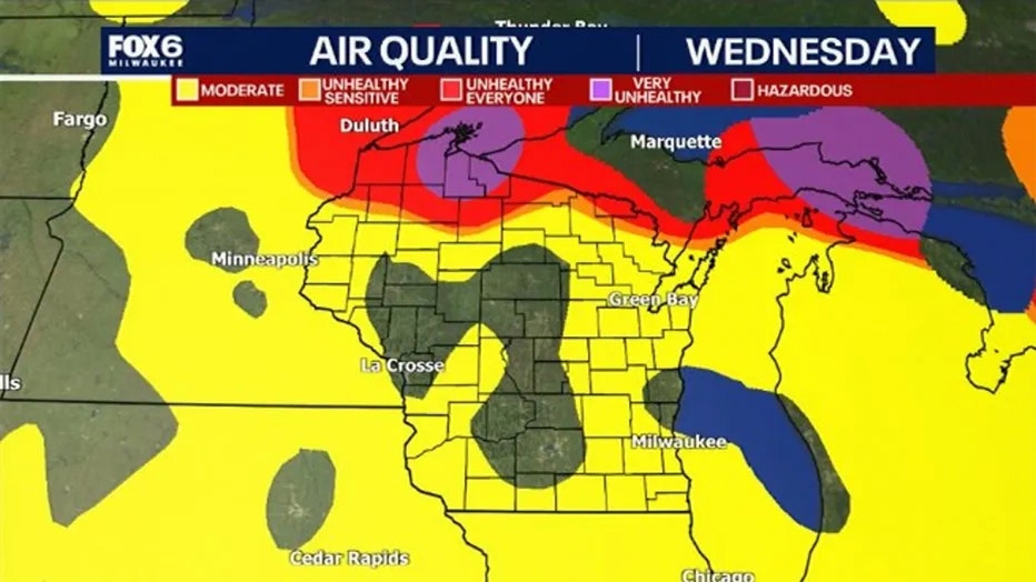
Image shows the current air quality alert in Wisconsin. (FOX 6 Now Milwaukee)
Big picture view:
FOX6 News Milwaukee reports that wildfire smoke has also led to poor air quality across Wisconsin.
The Wisconsin Department of Natural Resources issued an air quality advisory through noon Thursday, warning that air quality could range from "unhealthy for sensitive groups" to "very unhealthy," with brief periods of "hazardous" air quality possible in some locations.
Smoke is expected to reach east-central Wisconsin on Wednesday afternoon.
The haze will then expand into the Milwaukee metro and the rest of southeast Wisconsin on Wednesday evening and spread south toward the Illinois border overnight.
Almost all of Wisconsin could be under smoky conditions by Thursday, with the thickest concentrations expected in northwestern Wisconsin and enhanced smoke possible along Lake Superior and Lake Michigan.
The Source: This story uses information from the Minnesota Pollution Control Agency.