

Light snowfall hits Gunflint Trail area in northern Minnesota

Photo shared by the National Weather Service in Duluth shows snowfall (Supplied)
GRAND MARAIS, Minn. (FOX 9) - Images show light snowfall near the Gunflint Trail as temperatures drop in northern Minnesota.
Snowfall hits Gunflint Trail area
Big picture view:
The National Weather Service in Duluth shared images showing the snowfall near the End of the Gunflint Trail.

Photo shared by the National Weather Service shows snowfall at the End of the Gunflint Trail. (Supplied)
An image of the snowfall shared by Gunflint Lodge shows snow accumulating along the Gunflint Trail.

Photo shared by Gunflint Lodge and Outfitters shows snowfall along the Gunflint Trail. (Supplied)
Trail camera images also show snowfall just a few miles away from the Gunflint Trail.

Image shows light snowfall near the Gunflint Trail in northern Minnesota. (FOX 9)
Snowfall across Minnesota this weekend
MN weather: Friday forecast update
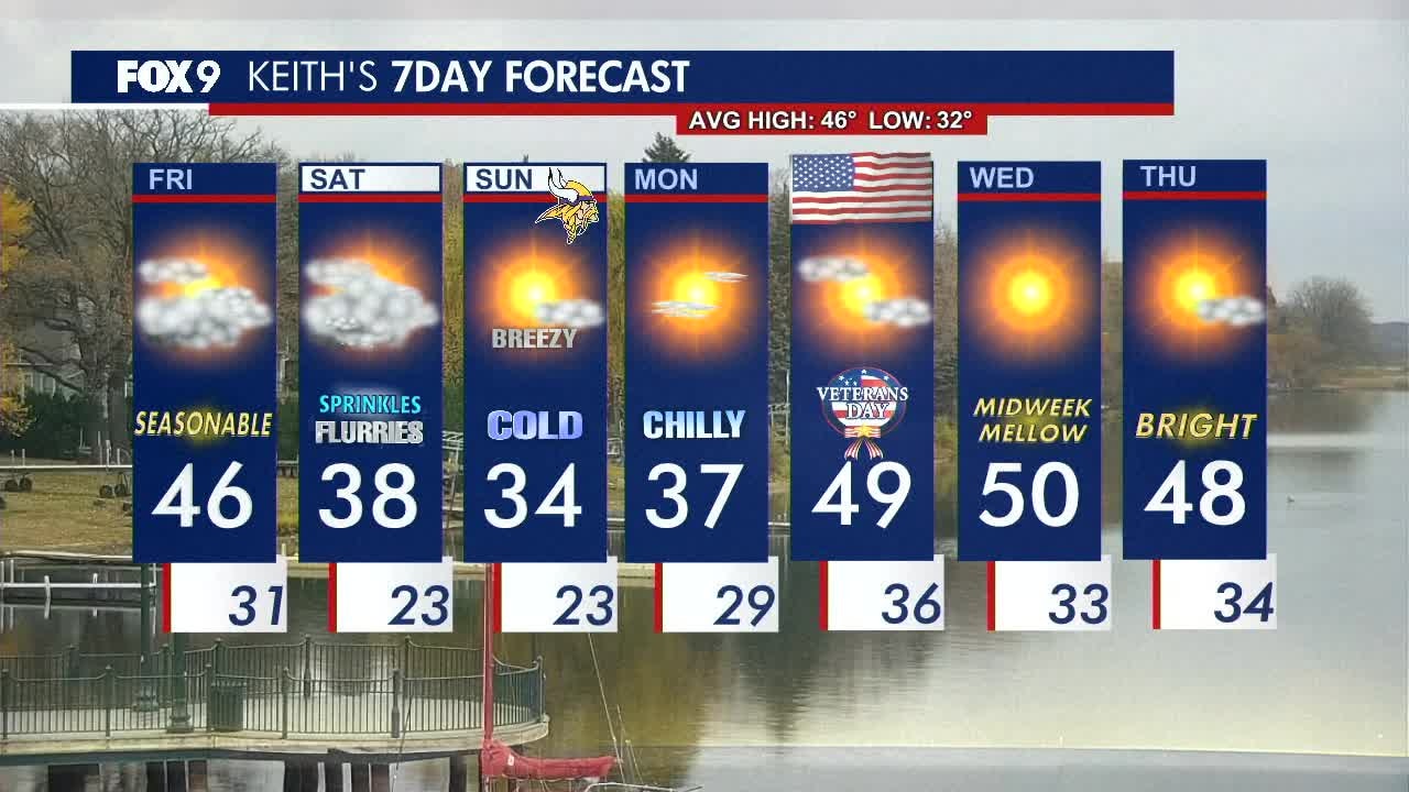
Expect a chilly and mostly cloudy Friday afternoon with highs topping out in the 40s. FOX 9 meteorologist Keith Marler has the full forecast.
What's next:
The weekend will be chilly and cloudy with below average temperatures in the 30s. Light snowflakes and sprinkles are possible in the metro on Saturday, with the best chance for light accumulation in southwestern Minnesota.
That slushy clipper system is expected to cover parts of the Dakotas and Iowa as well as parts of the Interstate 90 corridor in southern Minnesota.
Sunday turns blustery and cold with wind chills in the low 20s. That raw cold will be felt all through the day on Sunday.
Temperatures are expected to rebound by early next week, warming back into the upper 40s by Tuesday.
First snowfalls of years past
Why you should care:
Between late October and early November is when the first snowfall typically hit the Twin Cities.
The dates of the first accumulating snowfall for past years can be viewed below:

First accumulating snowfall over the years. (FOX 9)
The Source: This story uses information and images shared by Gunflint Lodge.