


Storms overnight before another hot day on Tuesday
Alex Lehnert has your Monday night forecast after another brutally hot day in Minnesota.
Alex Lehnert has your Monday night forecast after another brutally hot day in Minnesota.

Finding relief from the heat
Due to Juneteenth being declared a federal holiday, many federal buildings are closed Monday in the Twin Cities – leaving some seeking other resources for relief from the heat.
Due to Juneteenth being declared a federal holiday, many federal buildings are closed Monday in the Twin Cities – leaving some seeking other resources for relief from the heat.


Minnesota weather: Extreme heat peaks Monday with highs near 100
The extreme heat peaks on Monday in Minnesota with high temperatures near 100 degrees and a heat index that will feel like 106 degrees, thanks to the humidity.
The extreme heat peaks on Monday in Minnesota with high temperatures near 100 degrees and a heat index that will feel like 106 degrees, thanks to the humidity.

Monday's forecast: Hot! Excessive heat warnings remain
Highs will be very close to 100 degrees. Tuesday cools a little.
Highs will be very close to 100 degrees. Tuesday cools a little.

Minnesota weather: Monday expected to be another scorcher
After a blast of heat sent thermometers heading towards 100, Monday is expected to be as hot. An excessive heat warning remains in effect until early Tuesday morning for the metro and parts of western Minnesota.
After a blast of heat sent thermometers heading towards 100, Monday is expected to be as hot. An excessive heat warning remains in effect until early Tuesday morning for the metro and parts of western Minnesota.

Minnesota weather: Extreme heat ahead
Afternoon highs in mid to upper 90s Sunday. Heading into Monday, temperatures will be hot with highs in the upper 90s and heat index well into the triple digits.
Afternoon highs in mid to upper 90s Sunday. Heading into Monday, temperatures will be hot with highs in the upper 90s and heat index well into the triple digits.


Minnesota weather: Hot and humid Sunday, temps near 100 Monday
After a warm but comfortable Saturday, we're bracing for a big heat wave to carry us through the rest of the weekend.
After a warm but comfortable Saturday, we're bracing for a big heat wave to carry us through the rest of the weekend.


Minnesota weather: Spend Saturday outside, heat and humidity high Sunday
Saturday afternoon temperatures for Central and Eastern Minnesota will warm into the upper 70s to low 80s. An excessive heat watch is in effect for Sunday and Monday for most of Central Minnesota as temperatures jump into the mid-90s.
Saturday afternoon temperatures for Central and Eastern Minnesota will warm into the upper 70s to low 80s. An excessive heat watch is in effect for Sunday and Monday for most of Central Minnesota as temperatures jump into the mid-90s.


Minnesota weather: Heat, humidity return, with high near 100 on Monday
After Friday's glorious weather, dangerously hot and humid conditions are expected Sunday and Monday.
After Friday's glorious weather, dangerously hot and humid conditions are expected Sunday and Monday.

Minnesota weather: Glorious Friday, hot this weekend
Highs in the 80s on Friday, cooler Friday night ? probably the last night you can keep the windows open. Saturday will be cloudy with highs in the 80s, and it'll be hot and humid on Sunday. It could be close to 100 by Monday.
Highs in the 80s on Friday, cooler Friday night ? probably the last night you can keep the windows open. Saturday will be cloudy with highs in the 80s, and it'll be hot and humid on Sunday. It could be close to 100 by Monday.
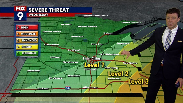

Minnesota experiencing transition day of rain before weekend heat
Most of Minnesota is in a transition phase Wednesday after a day of heat that saw temperatures reach nearly 100 degrees in the Twin Cities on Tuesday.
Most of Minnesota is in a transition phase Wednesday after a day of heat that saw temperatures reach nearly 100 degrees in the Twin Cities on Tuesday.

Wednesday's forecast: Early rain followed by seasonable temps
Thursday will see highs in 80s with windy conditions.
Thursday will see highs in 80s with windy conditions.
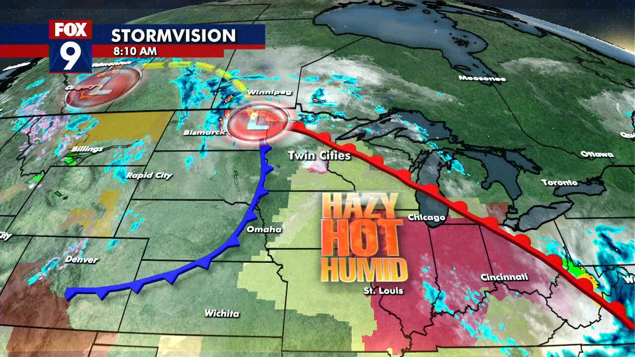
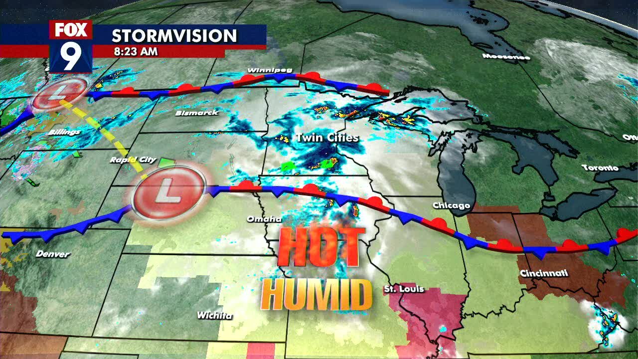
Tuesday's mid-day forecast: Hot! Heat index could top 100 degrees
The heat only lasts one day as tomorrow will be cooler with the possibility of strong storms.
The heat only lasts one day as tomorrow will be cooler with the possibility of strong storms.
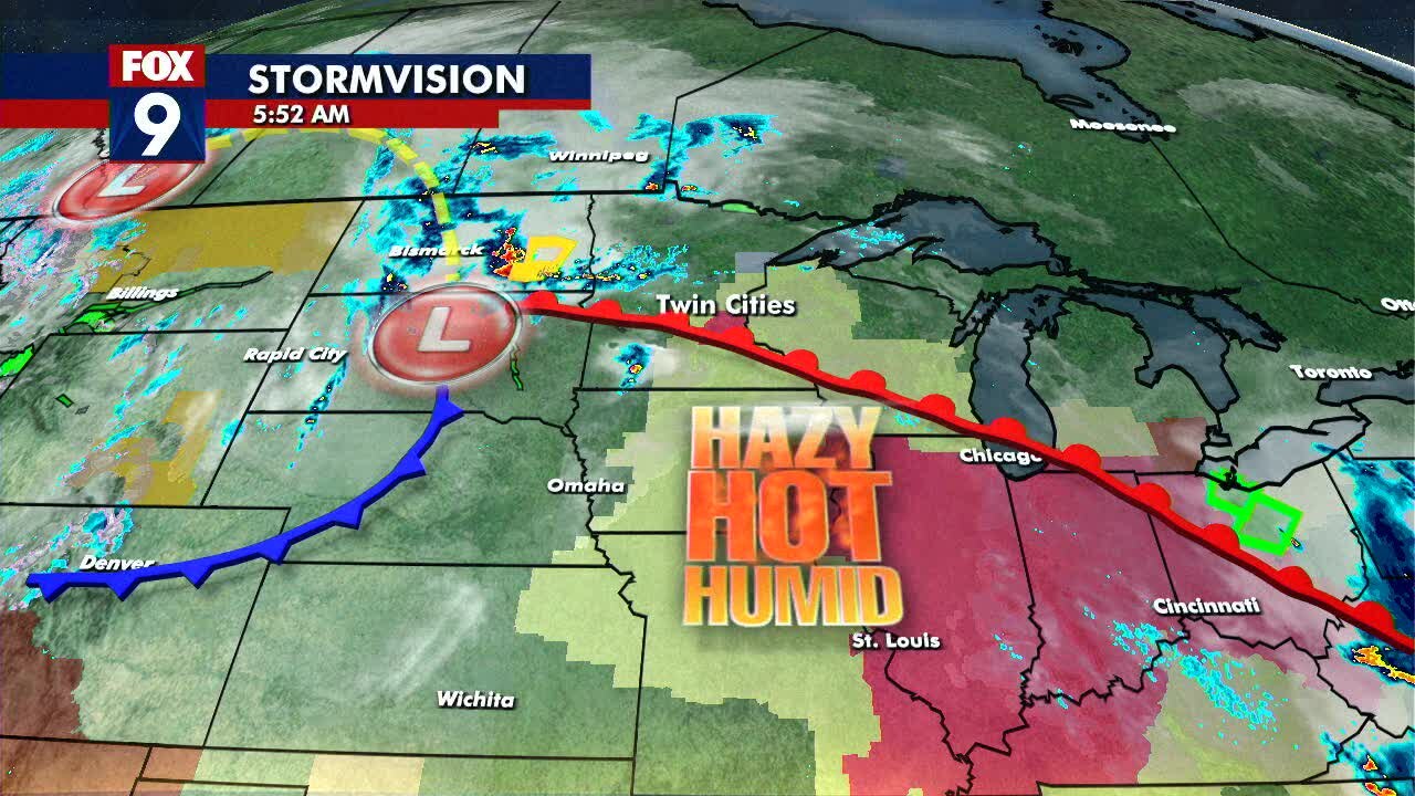
Tuesday's forecast: Highs near 100
It is going to be dangerously hot so take precautions to stay cool. Cool down comes tomorrow with a chance of strong storms.
It is going to be dangerously hot so take precautions to stay cool. Cool down comes tomorrow with a chance of strong storms.
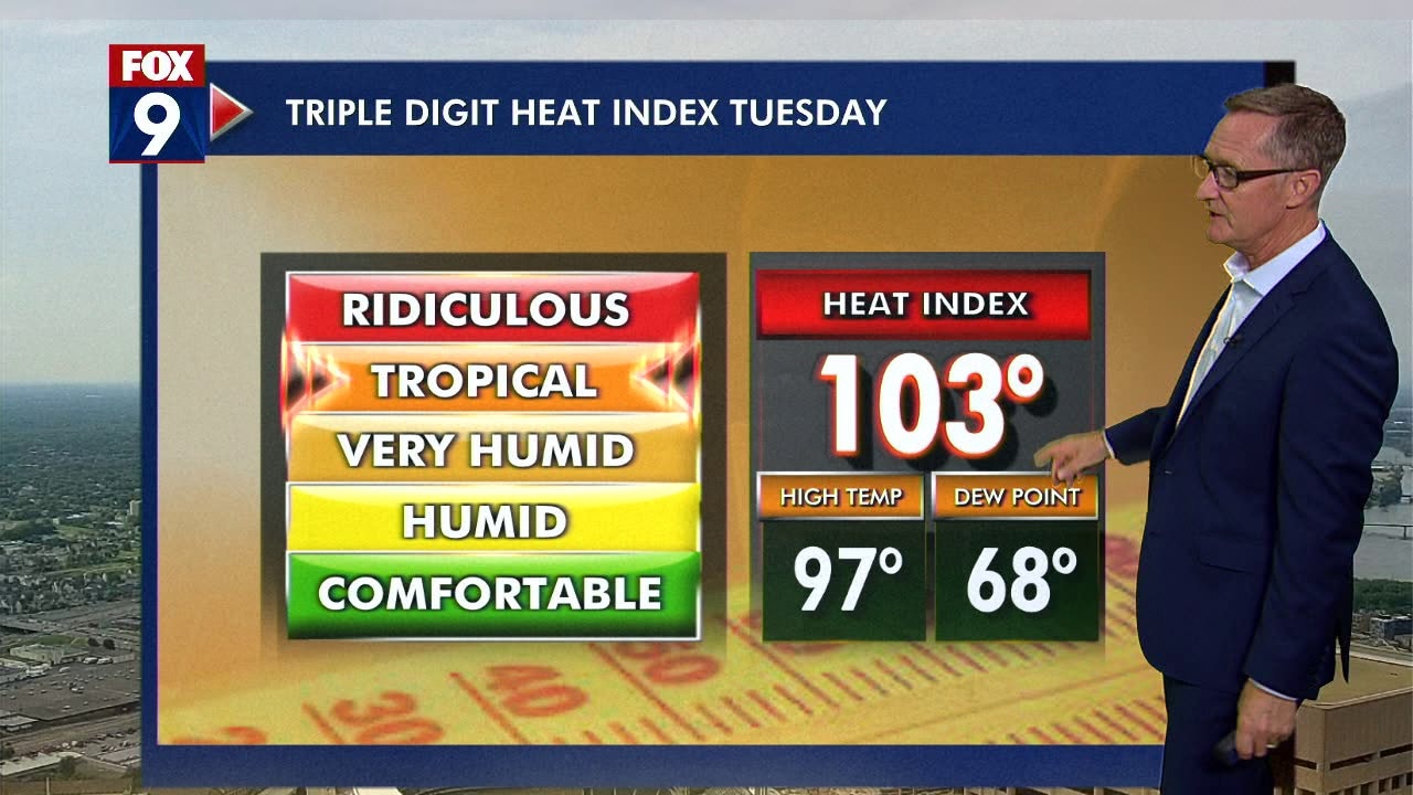
Minnesota weather: Heat warning in effect for Tuesday as temps push into 90s
Tuesday is shaping up to be a scorcher with high temps in the 90s and a heat index in the triple digits.
Tuesday is shaping up to be a scorcher with high temps in the 90s and a heat index in the triple digits.
Monday's midday forecast: Storms moving out of the area as the heat rolls in
Tuesday will be a hot one with temps near 100.
Tuesday will be a hot one with temps near 100.
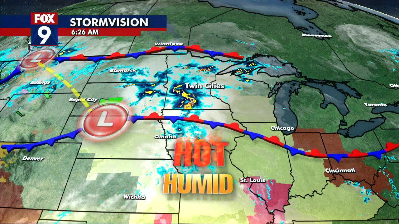
Monday's forecast: Spotty storms to start the work week
Then the heat will arrive with temps Tuesday near 100 degrees in the metro.
Then the heat will arrive with temps Tuesday near 100 degrees in the metro.


Minnesota weather: Warm weekend with some rain, pop-up thunder
After early morning showers in southern and western Minnesota, things will heat up on Friday.
After early morning showers in southern and western Minnesota, things will heat up on Friday.

Minnesota weather: Highs in the upper 70s and 80s, showers possible this weekend
Patchy clouds and pop-up showers are possible on Friday, with highs near 80 degrees. Showers will move in overnight and linger into Saturday morning.
Patchy clouds and pop-up showers are possible on Friday, with highs near 80 degrees. Showers will move in overnight and linger into Saturday morning.

Friday's forecast: Highs near 80s
The weekend could see some rain, but it'll be mostly warm and sunny
The weekend could see some rain, but it'll be mostly warm and sunny