

Strong winds, snow trigger blizzard warning for Twin Cities metro area

High impact winter storm impacts highways in Twin Cities metro
MnDOT crews are treating highways in the Twin Cities metro as a high impact winter storm moves through the Twin Cities metro area.
(FOX 9) - A high-impact winter storm is moving through Minnesota Wednesday as temperatures drop rapidly across the region and winds increase.
A blizzard warning was issued for Western Minnesota and the Twin Cities metro area Wednesday afternoon and it will stay in effect through 6 a.m. Thursday.
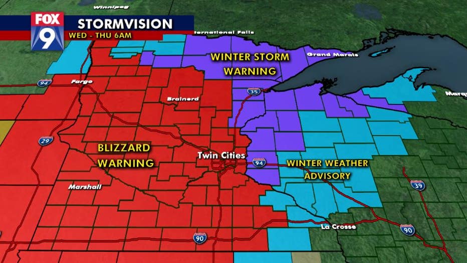
The Twin Cities are under a blizzard warning Wednesday as a high-impact winter storm moves through the area.
Wednesday morning rain left moisture on Minnesota roads that will freeze as snow continues this afternoon and evening.
Snowfall rates of 1" to 2" per hour are possible this afternoon for brief periods. Some areas of the Twin Cities metro can expect around 6-9 inches of snow.

Limited visibility in western Minnesota as winter storm moves in
There was limited visibility and blowing snow on Highway 10 near Moorhead, Minnesota, leading to some crashes and cars off the road. Video courtesy of the Minnesota State Patrol.
The afternoon snow will be coupled with wind gusts near 50 miles per hour, creating near zero visiblity at times into the early evening.
MnDOT issued a no-travel advisory due to the whiteout conditions.

Timelapse video shows rain turn to snow in Eagan
A timelapse video taken from an Eagan home's video doorbell shows the rain turn to snow Wednesday during a high-impact snowstorm.
Temperatures lingered around 30 degrees at noon, but will fall quickly down to 15 degrees by 6 p.m.
The snow is expected to taper off in the mid to late evening as the system tracks off to the east-northeast around mindight.

Blizzard conditions on Highway 10 in Waconia
Icy roads and low visibility created nearly impossible driving conditions on Hwy. 10 West in Waconia, Minnesota Wednesday.
The Winter Storm Warning will stay in effect through 6 a.m. Thursday in the greater Twin Ctieis metro area.
A deep freeze is possible overnight with sub-zero temperatures and dangerous wind chills in the -20 to -30 degrees range.
Stay up to date on the winter weather by downloading the FOX 9 Weather App. It has the latest temperatures, snow totals, forecasts and school closings 24/7. Download it for Android or Apple.