

The Twin Cities breaks yet another warmth record this year

Wednesday's forecast: Wildfire smoke leaves the area, highs in the upper 70s
Temps kick up Thursday to the mid-80s.
(FOX 9) - For those of you not quite satisfied by the length of our warmth in the Twin Cities this year, you may need to reconsider where you live.
This year more than any, the Twin Cities has had long-lasting warmth. While the metro just experienced the 13th warmest summer on record, it was actually cooler than last year. This is mostly because of a lack of large stretches of 90s that we endured last summer.
Now, our 90s may have been less numerous, but the persistence of our relatively warm afternoon temperatures just leaped past any other year on record, dating back to 1872.
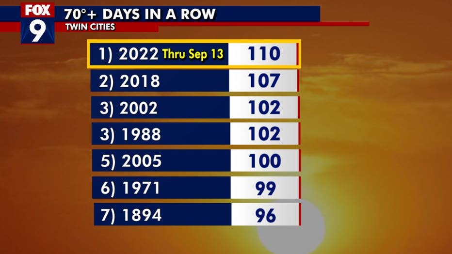
The Twin Cities has now tallied 110 days in a row where the high temperature reached at least 70°. (FOX 9)
The Twin Cities has now tallied 110 days in a row where the high temperature reached at least 70°. That is now the longest such stretch on record. That means that we have had highs in the 70s and higher since May 26th.
Now, our average highs from the end of May through mid-September are in the 70s and 80s anyway, so you would think that temperatures would fall in line accordingly. However, it is commonplace to get a random rainy day or two sometime in June or early September where temperatures get stuck in the 60s. This is pretty "normal" even in very warm years, but didn't happen this year in part because of our drought, with the rainy days ending up outside of central Minnesota.
Tough to conclude anything more than sheer ridiculous luck for our stretch of 70-degree-plus days, although an argument could be made that the dry conditions led to it, especially since most years on this list are sub-average in summer rainfall. However, what may be far more telling is our stretch of 50-degree-plus nights in a row.
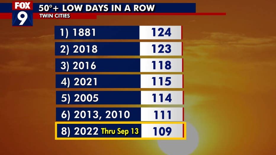
Most of the recent "consecutive days above 50 degrees" streaks have occurred in the last decade, possibly because of the Metro "heat island." (FOX 9)
While we are still "only" in eighth place this year, we have now seen 109 consecutive days where low temperatures were at or greater than 50 degrees. But if you look at the list, all but one of the years have occurred in the last two decades... the most recent of which was just last year. This is VERY telling. There may be some hesitation to directly relate it to climate change, which is reasonable, however this cements that the Urban Heat Island effect is very much responsible for this as the Twin Cities metro continues to grow with our impervious surfaces able to hang on to far more heat overnight.