

MN weather: 3 possible tornadoes, large hail hit southern Minnesota

Tornadoes, large hail, heavy rain hit southern Minnesota
Southern Minnesota was hit hard by the first severe weather of the season Monday afternoon and evening, with at least two tornadoes, large hail and heavy rain. FOX 9's Soyoung Kim has more.
MINNEAPOLIS (FOX 9) - Minnesota's first severe weather event of the 2026 season hit southern Minnesota hard Monday afternoon and evening.
There were as many as three possible tornado touchdowns, very large hail and heavy rain that hit several Minnesota communities. The storms ignited just after 4 p.m. Monday, and continued throughout the afternoon and evening as they rolled across southern and southeastern Minnesota, and into western Wisconsin. Along with the possible tornado touchdowns, there were dozens of reports of hail.

Videos of hail across Minnesota during severe Monday storms
Storms pushed through parts of Minnesota on Monday evening and brought significant hail. In Rice County, there were hail reports of up to three inches in diameter. Elsewhere, there were egg and golf-ball-sized hail reported in Faribault and ping ping ball-sized hail reported in Cannon Falls.
9:30 p.m. - National Weather Service reports 3 tornadoes
The National Weather Service says it has three confirmed reports of tornadoes from our first severe weather event of the season Monday afternoon and evening in southern Minnesota.
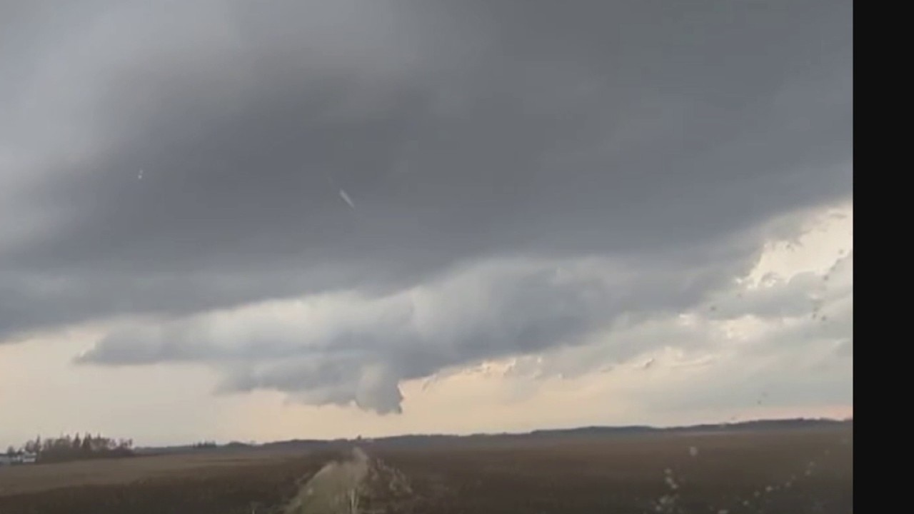
A reported tornado touched down west of Amboy. Another captured by FOX Weather hit the southern Minnesota town of Truman.
So far, there are no significant reports of damage or injuries as a result of Monday's severe weather. As of 9:45 p.m., NWS officials say all tornado warnings have expired, and the threat is over for the evening.

Reported tornado hits southern Minnesota town of Truman
Severe storms hit southern Minnesota Monday afternoon and evening, prompting thunderstorm and tornado warnings over several hours. Two tornadoes were reported, one near the town of Truman, and the other near Amboy.
8:15 p.m. - Severe threat limited to far southern Minnesota
The National Weather Service reports storms are beginning to cluster together, and the severe threat is limited to far southern Minnesota, with damaging winds and large hail as the primary threats. Areas along and north of the line from Saint James and Mankato towards Red Wing and Eau Claire are all clear, outside of some stray showers.
6:25 p.m. - Confirmed tornado near Amboy
A confirmed tornado was reported on the ground at 6:25 p.m. Monday west of Amboy, Minnesota in southwest Blue Earth County. The tornado remained on the ground through 6:46 p.m. and damage was reported to a farm outbuilding.
Tornado reported in southern MN during storms
A tornado has been reported in southern Minnesota as severe storms push through on Monday.
6:15 p.m. - Tornado Warning in Blue Earth County
The National Weather Service issued a Tornado Warning for Blue Earth County, Martin County and Watonwan County until 6:45 p.m. Just before 6 p.m., a severe thunderstorm capable of producing a tornado was located about six miles northwest of Truman, or 17 miles north of Fairmont, moving east at 20 mph.
The storm includes hail up to tennis ball size. The locations impacted include South Branch, Truman and Lewisville.
6 p.m. - Line of storms races across southern Minnesota
Southern Minnesota continues to get hit hard by severe thunderstorms Monday night, after Rice and Goodhuse Counties dealt with Tornado warnings earlier in the day. A line of severe storms has developed from just north of Worthington, through Mankato, Faribault and Northfiled and is tracking east to northeast.
These storms have a history of producing up to 3" hail, heavy rain and rotation capable of producing a tornado. A Severe Thunderstorm Warning was issued for this line until 7 p.m.
5 p.m. - Storm drops large hail in southern Minnesota
Storms that are pushing through Minnesota on Monday have brought some significant hail, photos show.

(Supplied)
According to the National Weather Service, in Rice County, where there was a tornado warning, there have been hail reports of up to three inches in diameter. Elsewhere, there were egg and golf-ball-sized hail reported in Faribault and ping ping ball-sized hail reported in Cannon Falls.
Videos of hail across Minnesota during severe Monday storms
Storms pushed through parts of Minnesota on Monday evening and brought significant hail. In Rice County, there were hail reports of up to three inches in diameter. Elsewhere, there were egg and golf-ball-sized hail reported in Faribault and ping ping ball-sized hail reported in Cannon Falls.
Also in Faribault, the weather service shared a photo showing a heavy dropping of hail that was so voluminous that there was enough to be plowed.
4:45 p.m. - Tornado Warning issued in Goodhue County
The National Weather Service issued a Tornado Warning for Goodhue County until 5:15 p.m. A severe thunderstorm capable of producing a tornado was located about nine miles south of Cannon Falls, or 14 miles east of Northfield, moving east at 15 mph. Locations impacted include Wastedo, Wanamingo and Hader.
A Severe Thunderstorm Warning was issued for Goodhue County until 5:30 p.m. A tornado-warned storm had a history of producing hail up to three inches in diameter. The areas impacted include Cannon Falls, Goodhue and Wanamingo.
The National Weather Service says additional storms are firing along a line from Mankato toward west central Wisconsin.
4 p.m. - Tornado Warning in Rice County
The National Weather Service issued a Tornado Warning for Rice County until 4:30 p.m. A tornado-warned storm is hitting near Nerstrand, and large hail – golf ball-sized, egg-sized and teacup-sized – has been reported near Faribault.
Tornado Warnings have also been issued for Wanamingo and Dennison, Minn., until 5:15 p.m.
3:40 p.m. - Severe Thunderstorm Warning in southern Minnesota
A Severe Thunderstorm Warning is in effect for Faribault, Northfield and Kenyon until 4 p.m. The storm reportedly contains hail as large as two inches.
3 p.m. - Tornado Watch until 10 p.m.
The National Weather Service has issued a Tornado Watch until 10 p.m. for portions of southern and southeastern Minnesota, northern Iowa and central and western Wisconsin. So far, the Twin Cities metro is not included.
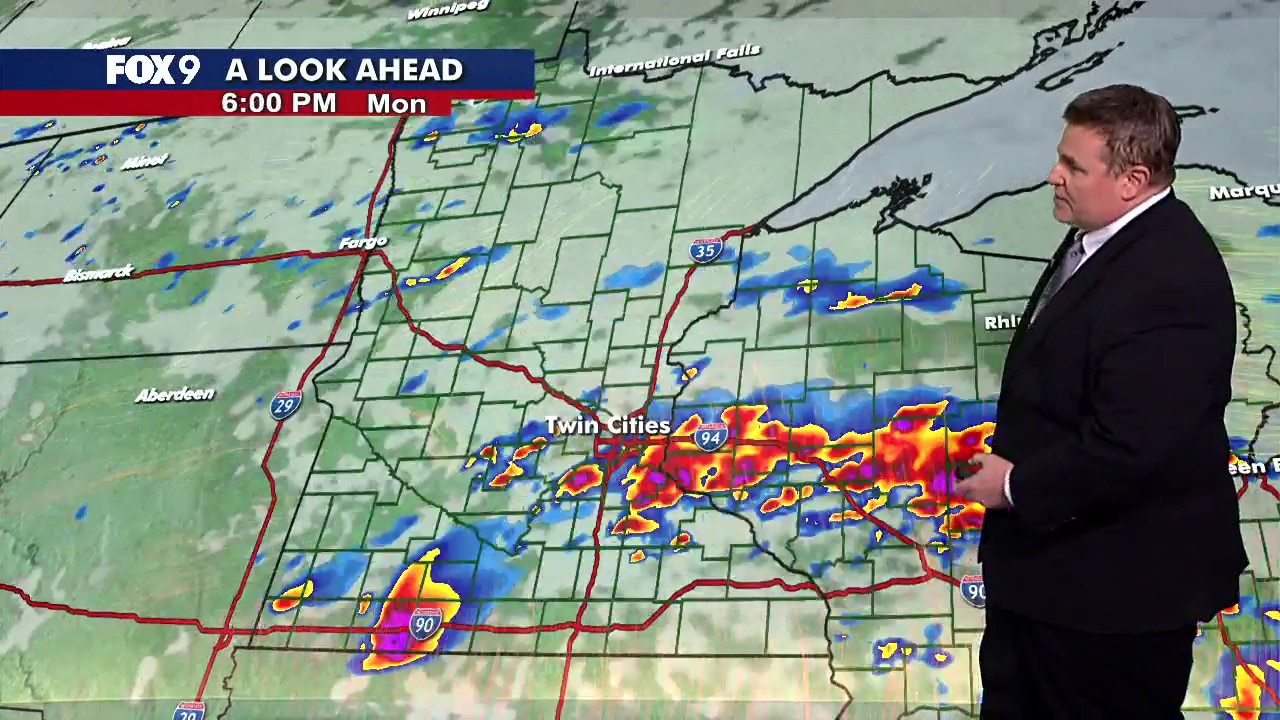
Temperatures in the 70s Monday afternoon, along with a stalled front in southern Minnesota are serving as the focal point for possible strong to severe storms in the afternoon and evening.
Monday started with portions of Minnesota, including the Twin Cities metro, at a Level 3 (Enhanced) risk for severe weather. The timing of these storms is between 4 p.m. and 11 p.m.
When the storms will hit, and where exactly. While tornadoes are possible with these potential storms, the greatest threats are very large hail and damaging winds.
The storms taper overnight, leaving behind cloud cover and the potential for patchy fog. Overnight lows fall into the 40s and 50s.
12 p.m.: Extended Minnesota weather forecast
MN weather: Severe storms possible Monday
FOX 9 meteorologist Keith Marler has the latest forecast update on potential severe storms in Minnesota on Monday afternoon.
Tuesday turns a bit cooler but remains above average, with highs in the 60s under a mix of sun and clouds.
Another chance for showers and possibly a few rumbles arrives Wednesday as temperatures warm back into the 70s.
Thursday looks warm and sunny, with highs near 75 degrees. Friday brings another round of rain and possible rumbles as temperatures warm into the upper 70s.
A cold front moves through for the weekend, dropping temperatures into the upper 40s Saturday with a chance for rain. Sunday rebounds closer to average, with highs in the mid-50s.