

What El Niño could mean for Minnesota's ice fishing season
(Jared Piepenburg / Supplied)
(FOX 9) - For generations of Minnesota anglers, the winter calendar is written on the hard water. But as any seasoned ice fisherman knows, no two winters are alike.
I’ve been seeing many posts on ice fishing and Minnesota fishing groups on Facebook asking questions as to when lakes will freeze over and what others think is on tap for this winter’s ice fishing season.
While there may not be a "normal" year for ice fishing conditions, history has shown that El Niño winters do have a trend in terms of length of the season and ice conditions. History gives us a decent blueprint for El Niño, but a rare atmospheric wild card in the Arctic could completely disrupt the season, proving that a single weather event can change everything on the ice.
What anglers can typically expect
(Jared Piepenburg / Supplied)
The primary driver behind many of Minnesota’s mildest winters is El Niño. For ice anglers, a standard El Niño winter typically means a delayed start to the season (which we are seeing right now as many local lakes still have water temperatures in the mid-50s for early November), a shorter season to be on the ice, and ice that behaves differently than it does during a classic Minnesota deep freeze.
Why you should care:
Historical data shows that strong El Niño winters don't just reduce the timeline of the ice; they often alter the structure and "type" of ice we get in those years.
Here is what "normal" looks like under these tropical conditions:
- Delayed ice-up and early melts: Standard long-term median ice-out dates usually land in mid-April for metro lakes (like Lake Minnetonka on April 13) and late April for northern basins (like Leech Lake on April 28). During El Niño, those timelines frequently compress, pushing lakes to freeze over later into December and threatening mid-March collapses.
- Thinner peak ice: Instead of building feet of rock-solid ice, El Niño winters historically restrict peak ice thickness to a narrower 11-to-17-inch range.
- Highly volatile top layers: Mild winter thaws frequently rot the top layer of ice into brittle, "honeycombed" structures, making shorelines muddy and early/late season foot traffic incredibly unpredictable.
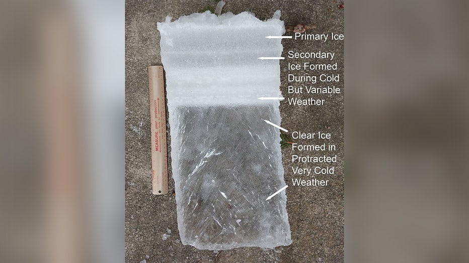
A core of lake ice showing primary ice at the top, secondary ice - formed during cold, but variable weather - below the primary ice, and clear ice - formed in protracted very cold weather - at the bottom. (John A. Downing/Minnesota Sea Grant / Supplied)
The Arctic wild card
Dig deeper:
While El Niño warms from the south, a phenomenon known as Sudden Stratospheric Warming (SSW) can completely disrupt the winter script from above.
Think of Sudden Stratospheric Warming as nature’s ultimate hard-water trigger. In the dead of winter, the polar vortex acts like a massive spinning top toy of freezing air locked high above the North Pole, basically keeping the brutal cold bottled up like a closed freezer door. But every so often, powerful atmospheric energy waves from the lower atmosphere surge upward and slam directly into it.
This collision causes high-altitude Arctic temperatures to warm very quickly over a few days. That sudden heat wave completely stalls or breaks up the vortex's spinning barrier. With the freezer door now wide open, that trapped, sub-zero Arctic air escapes, spilling straight down into the Upper Midwest to deliver the prolonged, severe cold outbreaks and potentially bringing good ice-making weather.
Timeline:
For anglers tracking the calendar, the frequency and timing of this wild card are critical:
- How often: SSW events occur every year, but the big ones occur roughly 6 times per decade (about once every two years). These are the years we get those sub-zero high temperatures.
- Typical window: The vast majority of these disruptions occur during the deep winter months of January and February, or occasionally early March.
- Early outliers: A major SSW occurring before January is actually very rare. The historical record for the earliest major polar vortex breakdown occurred on November 28 (in both 1968 and 2009).
- The current model trend: Long-range global weather models are actively indicating a record-breaking early SSW event establishing ahead of schedule this year. If this occurs, it will set up a highly unusual atmospheric collision: a tropical El Niño trying to warm the region while a fractured polar vortex tries to plunge us into a severe deep freeze.
Lesson of 2009: How individual storms flip script
Because of these competing global forces, this winter has only one real modern historical parallel: the winter of 2009–2010.
The backstory:
That winter provided an interesting blueprint of how a single local weather event can entirely rewrite an ice fishing season, regardless of global climate patterns:
- The quick freeze and the blanket: Following a rare early polar vortex breakdown on November 28, 2009, arctic air arrived in the Upper Midwest for the core winter months. December, January, and February all registered 1°F to 3°F colder than average, completely suppressing the underlying El Niño warmth and allowing the lakes to freeze.
- The untimely snowfall: However, that cold air arrived alongside a massive, heavy winter snowpack—including a historic Christmas Eve blizzard.
- The slush sandwich: That deep snow acted like a giant wool blanket over the freshly frozen lakes. It insulated the developing lake ice and stalled any deep, structural clear ice growth. Instead of building strong ice, the weight of the snow forced lake water to bubble up, creating 18 to 22 inches of weaker, slush-heavy "white ice."
- The flash melt: When the polar block dissolved in March 2010, the dormant El Niño pattern reasserted itself and it did it quickly. March temperatures averaged a staggering 7.9°F above average. Because the underlying ice sheets were structurally flawed from that early winter snow insulation, the ice experienced a rapid top-down "flash melt," causing almost every major basin in the state—from Minnetonka up to Vermilion—to shatter and go ice-out within a tight five-day window between April 2 and April 7.
Interpreting ice this winter
Local perspective:
If this winter mimics the 2009 blueprint, anglers cannot rely on standard thickness numbers alone. When evaluating how this season will treat your favorite fishing spot, look at the immediate, local conditions:
- Watch the early snow pack: A heavy snowstorm right after the lakes freeze over is an ice angler's worst enemy. It slows clear ice production and creates miserable, dangerous mid-winter slush pockets.
- Clear vs. opaque ice: Clear "blue" ice formed during steady, uninsulated cold snaps possesses twice the structural weight-bearing capacity of opaque "white ice" formed from melted slush or winter rain crusts.
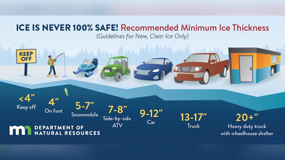
Recommended Minnesota ice thickness guidelines (Supplied)
Whether this winter brings a prolonged, stable truck-traffic season or a highly compressed foot-traffic window depends entirely on the timing of our first major snowfalls and how these arctic blocks hold up. To track historical trends or monitor ice-outs on lakes closer to your area, visit the Minnesota DNR’s Ice-Out Database.
Stay safe, never assume thickness equals safety, and let local conditions guide your steps on the hard water.
The Source: Information in this story comes from FOX 9 meteorologists, the Minnesota Department of Natural Resources and the Minnesota DNR State Climatology Office.