

Twin Cities’ biggest snow storms most often happen in March, DNR data shows
MN weather: What to expect with this weekend's storm
The biggest snow of the season is coming Saturday night into Sunday afternoon. Here's what to expect in Minnesota with this weekend's winter storm.
MINNEAPOLIS (FOX 9) - While March may be associated with the start of spring, historical data shows it has produced more of the Twin Cities’ largest snowstorms than any other month.
History of Twin Cities snowstorms
The backstory:
According to data from the Minnesota Department of Natural Resources, March has produced seven of the top 25 largest snowfall events in the Twin Cities dating back to 1884. This makes it the month with the most significant snowstorms on record.
The DNR suggests the heavy snowstorm season often occurs during the transition months like November and March. These two months account for 13 of the 25 largest snowstorms on record for the metro area.
Some of Minnesota’s most memorable snowstorms have occurred in these transitional periods, including the infamous 1991 Halloween Blizzard, which dropped 28.4 inches of snow in the Twin Cities. Several March storms also made the list, including the March 3-4, 1985 storm and the March 11-14, 1940 storm, which both delivered 16.7 inches.
According to the DNR, the number of ranked storms wholly or partially occurring during each month is:
- March: 7
- November: 6
- December: 5
- January: 4
- April: 3
- February: 2
- October: 1
Biggest snowstorm of the season this weekend

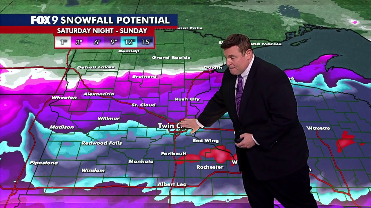
Snowfall potential for this weekend's winter storm.
What's next:
The region could see the biggest snow storm of the season this weekend.
At this point, the areas in the winter storm watch and warning areas should prepare for heavy snow and difficult travel conditions as the storm unfolds late Saturday night into Sunday afternoon. It needs to be said that with a spring snow event there is tremendous uncertainty of the exact storm track, so it can be next to impossible to nail down exact snow totals up until a few hours of the onset of the storm.
This is a scenario that often brings double-digit totals in the heaviest band of snow. For the moment, the highest likelihood for those numbers will be toward southeast Minnesota and across southwest Wisconsin. However, pockets of heavy snow are possible for the greater Twin Cities as the storm intensifies early Sunday morning.
The forecast will definitely change as we get closer to the event, but as of Friday afternoon, the map above shows the snowfall potential for Minnesota and much of Wisconsin. The red shading southeast of the Twin Cities shows the potential for more than 18 inches of snow.
FOX 9 will keep you updated with the very latest as this unfolds through the weekend. Stay with FOX 9 for updates and download the FOX 9 Weather app for location-based alerts.
The Source: This story uses information from the Minnesota DNR and FOX 9 meteorologists.