

Red flag warning issued for western Minnesota counties

MN weather: Record warmth possible on Monday
It's a warm start to the week, with possible record warmth in the Twin Cities metro on Monday. However, a cold front moving in overnight will drop temperatures back into the 40s on Tuesday before warming back into the 60s and 70s for the end of the week. FOX 9 meteorologist Cody Matz has your forecast.
MINNEAPOLIS (FOX 9) - A red flag warning has been issued on Monday for parts of western Minnesota due to an extreme fire risk.
Red Flag Warning
What to expect:
The National Weather Service issued a warning for 27 counties in northwest, west central, and southwestern Minnesota on Monday. The alert states that fires can spread quickly and grow out of control due to predicted strong winds and low humidity.
The red flag warning is in effect for the following counties:
- From 11 a.m. to 7 p.m.: Becker, Clay, Clearwater, Grant, Hubbard, Mahnomen, Norman, Otter Tail, Wadena and Wilkin counties.
- From 2 p.m. to 8 p.m.: Chippewa, Douglas, Kandiyohi, Lac Qui Parle, Meeker, Pope, Redwood, Renville, Stearns, Stevens, Swift, Todd, and Yellow Medicine counties.
- From 2 p.m. to 9 p.m.: Big Stone, Traverse, Lincoln and Lyon counties.

Minnesota fire danger map as of 9 a.m. (Credit: Minnesota DNR) (Minnesota DNR / Supplied)
Southwestern Minnesota fire danger is "very high", meaning fires can start easily and spread at a very fast rate. Sections of central Minnesota are at a "high" fire danger, while some areas of eastern Minnesota, including parts of the Twin Cities, are at a "moderate rate."
"Any spark could become a wildfire under Red Flag conditions," said Karen Harrison, DNR wildfire prevention specialist.
The Minnesota Department of Natural Resources (DNR) urges residents in these counties to refrain from burning items while a red flag warning is in effect. Additionally, the department will not issue or activate open burning permits for large vegetative debris burning.
Officials also discourage campfires and advise anyone who has recently burned anything to ensure the fire has been completely extinguished.
Fire danger and burning restrictions in Minnesota can be found on the DNR's website here.
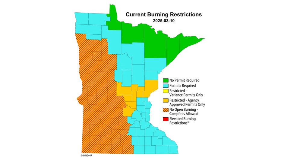
Burning restrictions in Minnesota as of 9 a.m. (Credit: Minnesota DNR) (Minnesota DNR / Supplied)
Record warmth possible Monday
Monday's forecast:
Monday will come with very warm temperatures, a bit of a breeze and a fire danger for parts of the state.
Temperatures will climb into the 60s and 70s across much of Minnesota on Monday, though areas along the Canadian border will see cooler highs in the 40s and 50s. The Twin Cities metro daytime high is 68 degrees, which would break the previous record of 66 degrees set in 2015 and 2012.
The afternoon will be a bit breezy with southwest winds at 10-20+ mph. A cold front will bring gusty winds of 30-35+ overnight, and cause temperatures to fall into the 20s for a chilly start on Tuesday.

The Source: A press release from the Minnesota DNR and FOX 9's meteorologists.