

Minnesota weather: Extreme heat warning with heat index of 100-110 degrees Monday
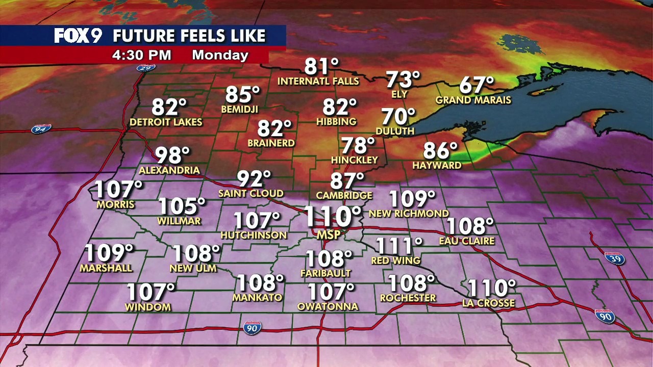
MN weather: Afternoon update on heat, storm chances
Dangerous heat continues across Minnesota, with an extreme heat warning in effect until midnight Tuesday. Severe storms triggered tornado warnings in northern Minnesota Monday afternoon, and additional storms are possible in the Twin Cities Monday night. FOX 9 meteorologist Keith Marler has the afternoon forecast update.
MINNEAPOLIS (FOX 9) - Dangerous heat settles into Minnesota on Monday as temperatures climb into the upper 90s and heat index values approach 110 degrees, prompting an extreme heat warning. A few storms are possible Monday night, with a level 2 slight risk of severe weather.
Do you prefer extreme heat or extreme cold? Vote at fox9.com/poll.
Monday's forecast in Minnesota
The forecast:
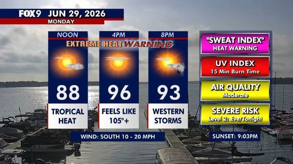
Monday turns dangerously hot and humid across Minnesota under mostly sunny skies.
Temperatures climb into the mid to upper 90s statewide, with the Twin Cities metro expected to reach around 97 degrees. Combined with dew points in the 70s, heat index values could climb between 100 and 110 degrees.
Most of Monday stays dry, but a few thunderstorms may develop after sunset and continue overnight. Any storm that forms could become severe, with hail and damaging winds the primary threats.
Monday night remains very warm and muggy, with lows only falling into the 70s.
Extreme heat warning and heat advisory
Extreme heat warning:
The National Weather Service has issued an extreme heat warning from 9 a.m. Monday through midnight Tuesday for parts of central and southern Minnesota, extending into northwest and west-central Wisconsin.
A heat advisory is also in effect for parts of western and north-central Minnesota, where heat index values could exceed 100 degrees.
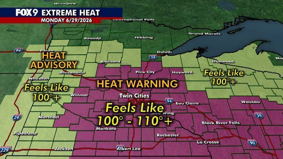
(FOX 9)
Storm chances Monday night
What to expect:
Dangerous heat and humidity will help fuel storm development Monday evening as a cold front pushes into western Minnesota. A strong cap in the atmosphere may delay storm formation, but if storms do develop, they could become severe.
A broken line of storms forms this evening as a cold front pushes through western Minnesota late this afternoon and rolls eastward toward western Wisconsin.
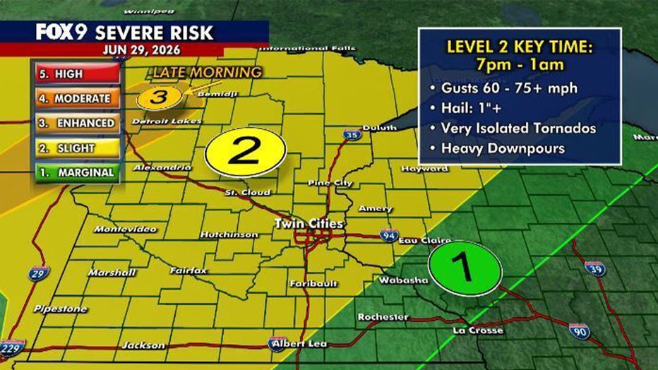
Much of Minnesota is under a level 2 slight risk for severe weather Monday evening. Northwestern Minnesota faces a level 3 enhanced risk late Monday morning into the early afternoon as an isolated severe storm moves northeast out of South Dakota.
The primary threats for these storms include damaging wind gusts between 60 and 75+ mph and hail ranging from 1 to 1.5 inches or larger. An extremely isolated quick spin-up tornado and locally heavy downpours are also possible.
Storms are expected to move into the Twin Cities metro between 9 p.m. and midnight, while the greatest threat across the FOX 9 viewing area runs from 7 p.m. to 1 a.m. Most of the storms should move east of Minnesota shortly after midnight.
Extended Minnesota weather forecast
What's next:
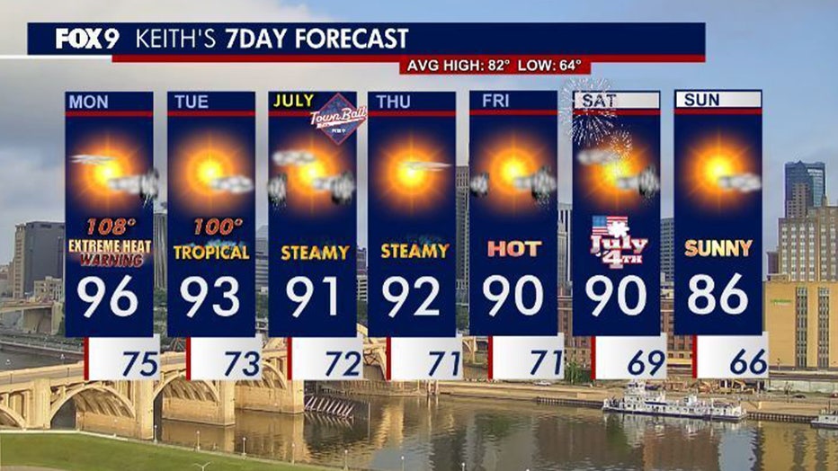
Tuesday remains hot and humid, with highs in the low 90s and heat index values near 100 degrees. Another round of thunderstorms could develop late Tuesday afternoon and evening before moving out overnight.
The pattern remains hot and unsettled through much of the week, with highs in the 90s and periodic storm chances.
Temperatures ease slightly into the 80s by the end of the holiday weekend.
Here's a look at the seven-day forecast:
(FOX 9)
The Source: This story uses information from FOX 9 meteorologists.