Extreme Heat Warning
until SUN 9:00 PM CDT, Carlton/South St. Louis Counties, Pine County, North Cass County, North Itasca County, South Aitkin County, South Cass County, Northern Aitkin County, South Itasca County, Crow Wing County, Hubbard County, West Otter Tail County, Wadena County, Grant County, East Becker County, West Polk County, Mahnomen County, Clay County, West Becker County, East Otter Tail County, Norman County, Wilkin County, Wabasha County, Fillmore County, Mower County, Dodge County, Winona County, Olmsted County, Rock County, Nobles County, Cottonwood County, Lincoln County, Murray County, Jackson County, Pipestone County, Lyon County, Freeborn County, Renville County, Chisago County, Scott County, Faribault County, Waseca County, Meeker County, Douglas County, Goodhue County, Sherburne County, Ramsey County, Wright County, Martin County, Dakota County, Kandiyohi County, Watonwan County, Yellow Medicine County, Lac Qui Parle County, Hennepin County, Le Sueur County, Mille Lacs County, Washington County, Redwood County, Steele County, Benton County, Nicollet County, McLeod County, Stearns County, Blue Earth County, Morrison County, Todd County, Stevens County, Anoka County, Pope County, Swift County, Kanabec County, Sibley County, Isanti County, Rice County, Brown County, Big Stone County, Traverse County, Douglas County, Washburn County, Burnett County, Buffalo County, Chippewa County, Barron County, Polk County, Dunn County, Eau Claire County, Pierce County, Pepin County

Dreaming of a white Christmas? Wednesday's storm could bring some snow
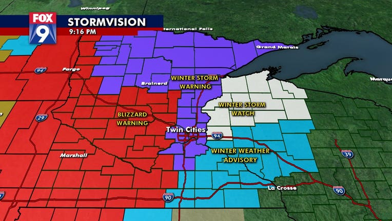
A map of winter storm warning and advisories in Minnesota for Wednesday Dec. 23, 2020.

Dreaming of a white Christmas? We may be in luck! While our upcoming system is set to bring some snow, it will also come with strong winds.

The FOX 9 meteorologists have been following the fluid forecast, which is quickly evolving into a high impact winter storm.

Snow will begin to develop into western Minnesota Wednesday morning, and track east through the afternoon. The Twin Cities metro area could get more than 6 inches of snow. Along with the snow, winds could gust up to 50 miles per hour for parts of Minnesota, which could cause blizzard conditions through the day, with low visibility and slick conditions possible. 

Temperatures on Wednesday will drop through the afternoon into the teens and 20s, before the big chill comes Thursday. 

Stay up to date on the winter weather by downloading the FOX 9 Weather App. It has the latest temperatures, snow totals, forecasts and school closings 24/7. Download it for Android or Apple

WeatherWinter WeatherMinnesotaHolidays