

Snow making for messy roads in MN

MN State Patrol safety tips for winter driving
Minnesota State Patrol Sgt. Jesse Grabow shares safety tips for drivers and explains the road conditions during Thursday’s snowstorm.
MINNEAPOLIS (FOX 9) - It's the largest snowfall of the season so far in the Twin Cities, and the snow is making for tricky driving conditions across the metro on Thursday.
A winter storm warning is in effect Thursday, with widespread 3-6 inches of snow accumulations possible along or near the Interstate 94 corridor by the time everything is done.
Dig Deeper:
- Snow totals so far
- Minnesota school closings for Dec. 19, 2024
- Timeline of what to expect with Thursday's snow
- Ground stop lifted at MSP Airport
Minnesota road conditions: Spinouts, crashes and backups
What we know: Snow fell through the morning commute, which made travel a bit difficult. Remember to drive with caution and give yourself extra travel time as crews work to clear the roadways.
It was slow-going on Minnesota roadways, with average speeds around 20 to 30 mph for much of the morning. Slippery road conditions took some drivers by surprise, while some roads were snow covered, so it was difficult to see where the lanes were.

Twin Cities largest snowfall of the season so far
It's the largest snowfall of the season so far in the Twin Cities. FOX 9 has team coverage on road and weather conditions Thursday morning, as this system could drop 3-6 inches of snow.
According to the Minnesota State Patrol, from midnight to 8:30 a.m., there were 91 property damage crashes, nine injury crashes, 28 vehicles off the road, four spinouts and five jackknifed semi-trucks on Minnesota roads.

A school bus went off the road in Brooklyn Center on Highway 100 on Thursday.
READ MORE: School bus slides into Brooklyn Center ditch, no injuries
The Minnesota Department of Transportation's website lists most roads in the Twin Cities being normal driving conditions. Here's a map of road conditions as of 7:30 p.m. Thursday:

Travel conditions as of 7:30 p.m. in Minnesota. (Supplied)
MSP Airport: Delays due to snow, ice
What we know: A ground stop has been lifted after being issued at MSP Airport until 10:15 a.m., with FAA now saying there is just a departure delay with an average of 30 minutes.
This comes after a ground delay was issued due to snow and ice, according to the FAA's website. The ground delay was in effect until at 9:59 a.m. A ground stop was previously issued for the airport, but expired at 7:30 a.m.
During the ground delay Thursday morning, the FAA's website said departures at the airport are delayed an average of 62 minutes.
According to MSP Airport's website, one departure has been canceled, and 39 departures have been delayed as of10:19 a.m. Meanwhile, four arrivals have been canceled and 36 have been delayed.
Rochester International Airport in southern Minnesota was closed Thursday morning, but reopened at 7:30 a.m.
What to expect with Thursday's snow

MN weather: Snow Thursday forecast update
FOX 9's Cody Matz shares an update on the forecast on Dec. 19, 2024.
Timeline: Here's what to expect with Thursday's snow across the Twin Cities:
- Thursday morning: Light to moderate snow will make for tricky road conditions for the morning commute; 2-4+ inches of snow is possible.
- Thursday afternoon: Lighter snow as flakes become more off and on, with some gusty breezes; another 1-2 inches of snow is possible.
- Thursday evening: Scattered flurries will taper as the snow moves out of the region. There may be some blowing and drifting snow; a dusting of snow is possible.
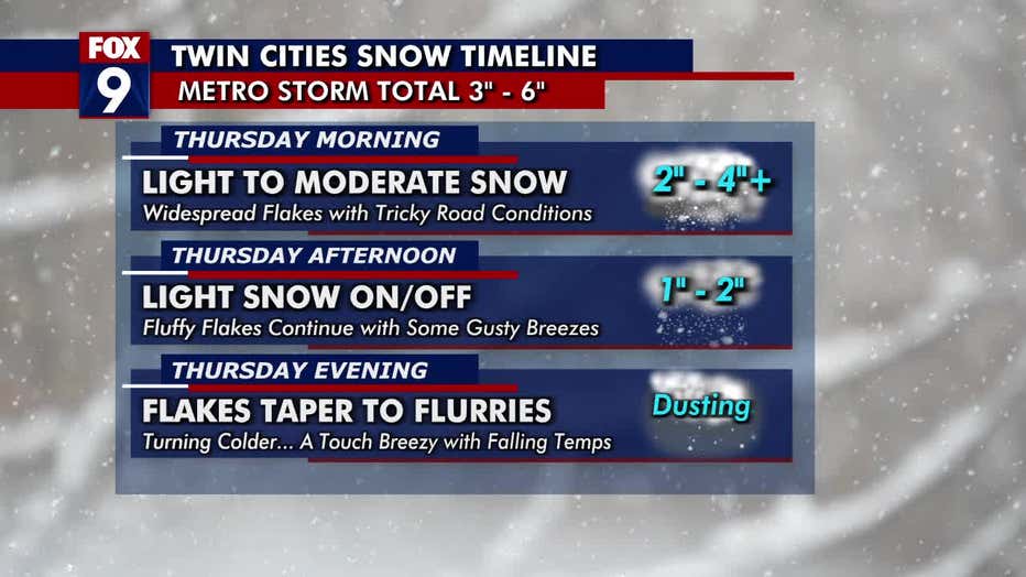
Snow accumulations are forecast to be in the 3-6 inch range around the Interstate 94 corridor. Farther south and north of the corridor will see snow totals in the 1- to 3- inch range.
Here's the snow potential map:

The high on Thursday will be around 26 degrees in the Twin Cities, but then it turns colder. The high on Friday will be in the teens, but it will feel more like single-digits.
Snow totals in Minnesota

MN weather: Snow totals from storm
After a snowy Thursday, Ian Leonard is looking at the snow totals from the storm and the week ahead for Super B
By the numbers: Thursday's snow is officially the largest snow of the season for the Twin Cities (we haven't gotten more than an inch in a single storm yet this season).
Here are the snow totals so far (note: It is still actively snowing, so snow totals are likely higher than what is listed below. These numbers will be updated):
- New Prague: 7 inches as of 4:30 p.m.
- Belle Plaine: 6.5 inches as of 4:30 p.m.
- Blakely: 6.5 inches as of 9 a.m.
- Rochester: 5.5 inches as of 10 a.m.
- Carver: 5.3 inches as of 8:30 a.m.
- Montgomery: 5 inches as of 7 a.m.
- Richfield: 5.2 inches as of 8:30 a.m.
- Savage: 5 inches as of 4:30 p.m.
- Northfield: 4.9 inches as of 7 a.m.
- Cannon Falls: 4.9 inches as of 8 a.m.
- Woodbury: 4.8 inches as of 4:30 p.m.
- Elko New Market: 4.8 inches as of 7 a.m.
- Lake City: 4.8 inches as of 9:35 a.m.
- Credit River: 4.6 inches as of 7 a.m.
- Bloomington: 4.4 inches as of 4:30 p.m.
- Faribault: 4.3 inches as of 7 a.m.
- Excelsior: 4.2 inches as of 8:30 a.m.
- Fridley: 4.1 inches as of 4:30 p.m.
- Minnetonka: 4 inches as of 8 a.m.
- Independence: 3.8 inches as of 7 a.m.
- Edina: 3.7 as of 7 a.m.
- Minneapolis: 3.9 inches as of 4:30 p.m.
- Eden Prairie: 3.5 inches as of 7:30 a.m.
- Zumbro Falls: 3 inches as of 7:10 a.m.
- Prior Lake: 3.2 inches as of 7 a.m.
- MSP Airport: 2 inches through 6 a.m.
Track the snow in Minnesota
What you can do: To get the latest updates and track the snowy weather, you can download the FOX 9 Weather app.