

Minnesota weather: Tropical heat remains Thursday with storm chances overnight
MN weather: Tropical heat Thursday with strong overnight storms
It will remain hot and humid Thursday with strong storms possible overnight.
(FOX 9) - Not much will change for Minnesota weather-wise the next couple of days as we’ll have heat, steam and some occasional thunderstorms around.
Thursday's forecast in Minnesota
The forecast:
There will be plenty of heat across central Minnesota Thursday with highs on either side of 90 in most cases.
Temperatures will be a little cooler to the south and south-east with isolated storm chances that will take us through Thursday afternoon and Thursday night, and a better opportunity for some widespread thunderstorms rolling out of the Dakotas into western and central Minnesota overnight.
Storm chances overnight Thursday
What we know:

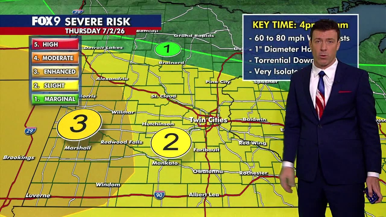
Severe weather outlook for Minnesota on Thursday, July 2, 2026.
Clusters of storms will be found across parts of the Upper Midwest on Thursday. The main severe threat for the Twin Cities metro will be late Thursday evening and overnight.
There are several zones of storms across the region on Thursday.
One of those will be in northern Iowa and southeastern Minnesota with isolated to widely scattered storms possible throughout the day as a frontal boundary remains rooted in the area.
The overall strength of these storms will be conditional on how much of a break can occur between rounds of storms, allowing the atmosphere to "recharge". The best chances for some isolated severe storms will still be late afternoon and the early evening.
The second batch to watch will be late Thursday evening and overnight. Storms are likely to develop in the Dakotas Thursday afternoon and roll into western Minnesota Thursday evening. These are the storms that could affect a lot of the area, including the metro. If these storms can form into a strong enough line, widespread straight-line winds will be possible.
If it's more clustered, then isolated gusty winds and large hail will be the main threats.
Extended Minnesota forecast
What's next:
Thunderstorm chances will linger overnight into the first part of Friday. They will kick out on Friday afternoon and then may do it all over again late Friday night into the first part of Saturday.
On Friday, there will be highs in the middle 80s, give or take, across the state, going for a high of 86 in the Twin Cities metro. Now there is an overnight thunderstorm chance from Friday night into early Saturday.
The rest of your Fourth of July will be quiet with maybe an isolated stray storm possible Saturday night, and then a little less humid after that. Next week, expect highs to remain in the mid to upper 80s.
The Source: This forecast uses information from FOX 9 meteorologists.