

Minnesota weather: Rain totals from Monday and Tuesday showers
MN weather: Rain fades for fairly cloudy Tuesday
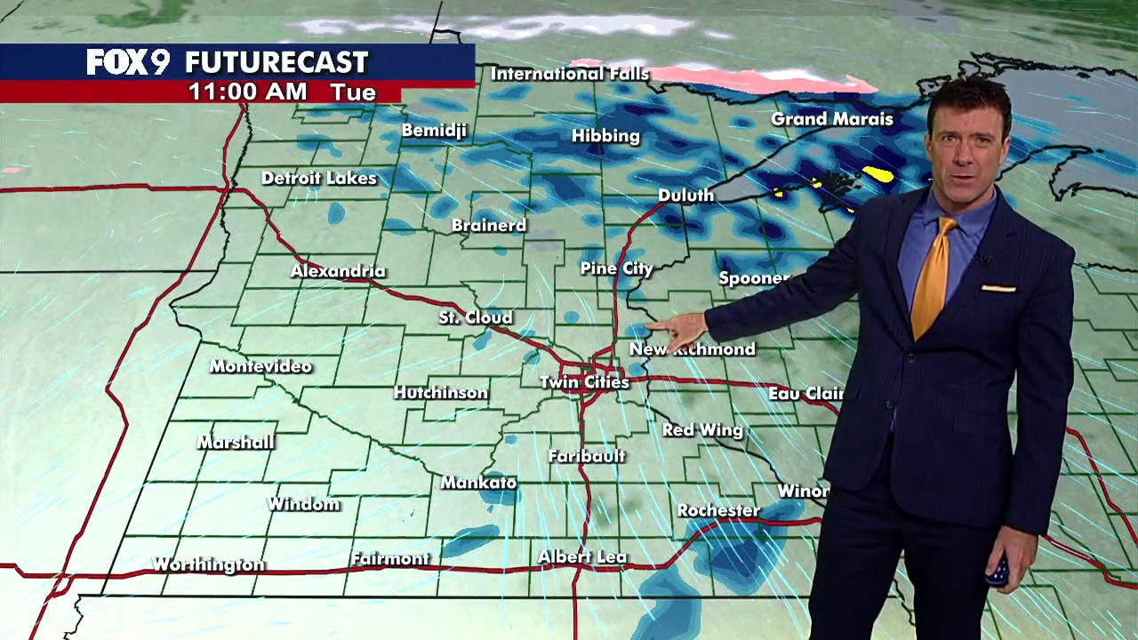
Tuesday starts with lingering showers before turning drier and slightly warmer during the afternoon, though clouds will stick around. FOX 9 meteorologist Cody Matz has the latest forecast and a look at when thunderstorms could return.
MINNEAPOLIS (FOX 9) - Steady rain moved across Minnesota Monday and into Tuesday, bringing more than half an inch of rain to many areas in the Twin Cities metro.
Rainy start Tuesday
The backstory:
Rain showers continued Tuesday morning and are gradually clearing out to the north and east. A few scattered sprinkles could linger through the afternoon, but conditions are expected to turn drier with mostly cloudy skies.
The steady rainfall brought more than half an inch of rain across much of the Twin Cities metro, with some areas approaching an inch. Rainfall totals varied outside the metro, with some areas in central and southern Minnesota receiving more than half an inch.
Here's a look at the rain totals from Monday into Tuesday morning.
Minnesota rain totals
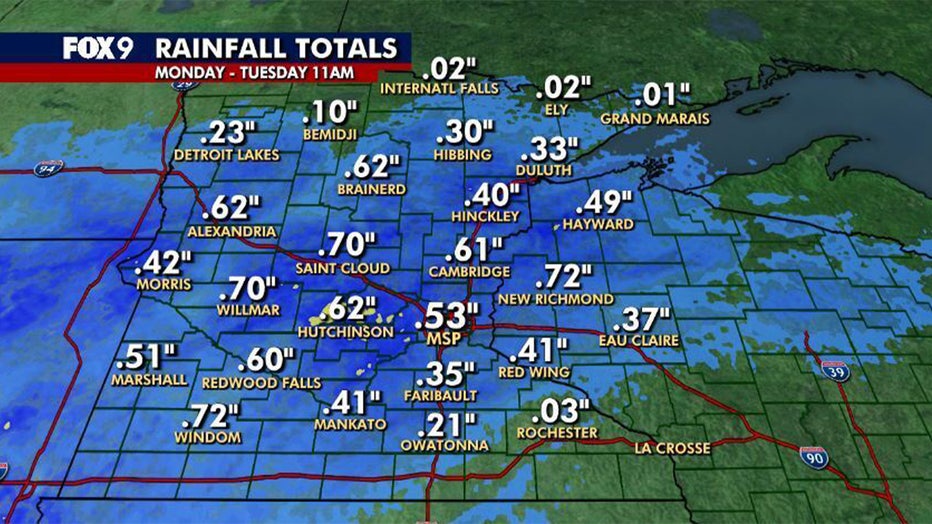
Statewide rainfall totals as of 11 a.m. on Oct. 27, 2026. (FOX 9)
Here are the rain totals across the state as of 11 a.m. Tuesday
- New Richmond: 0.72 inches
- Windom: 0.72 inches
- Saint Cloud: 0.70 inches
- Willmar: 0.70 inches
- Brainerd: 0.62 inches
- Alexandria: 0.62 inches
- Hutchinson: 0.62 inches
- Cambridge: 0.61 inches
- Redwood Falls: 0.60 inches
- Minneapolis-St. Paul Airport (MSP): 0.53 inches
- Marshall: 0.51 inches
- Hayward: 0.49 inches
- Morris: 0.42 inches
- Mankato: 0.41 inches
- Red Wing: 0.41 inches
- Hinckley: 0.40 inches
- Eau Claire: 0.37 inches
- Faribault: 0.35 inches
- Duluth: 0.33 inches
- Hibbing: 0.30 inches
- Detroit Lakes: 0.23 inches
- Owatonna: 0.21 inches
- Bemidji: 0.10 inches
- Rochester: 0.03 inches
- International Falls: 0.02 inches
- Ely: 0.02 inches
- Grand Marais: 0.01 inches
Twin Cities metro rain totals
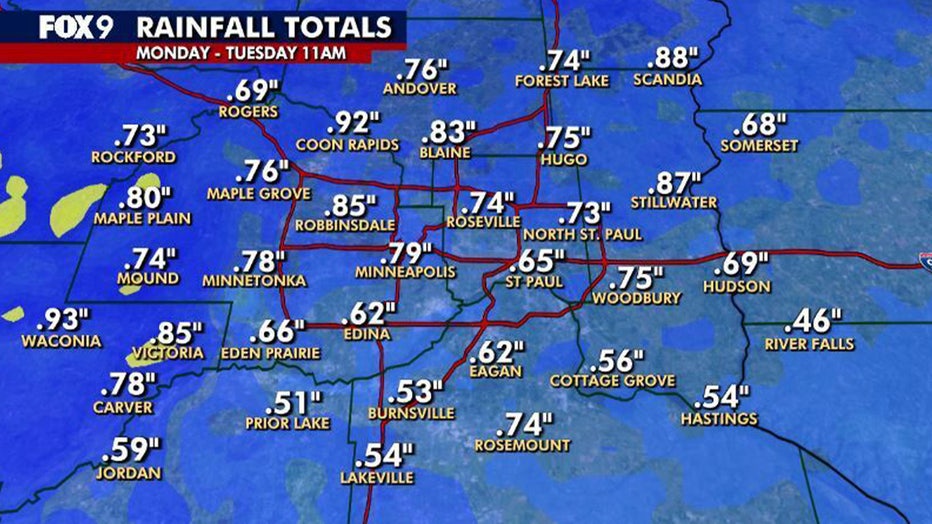
Twin Cities metro rainfall totals as of 11 a.m. on Oct. 27, 2026. (FOX 9)
Here are the rain totals across the Twin Cities metro as of 11 a.m. Tuesday.
- Waconia: 0.93 inches
- Coon Rapids: 0.92 inches
- Scandia: 0.88 inches
- Stillwater: 0.87 inches
- Robbinsdale: 0.85 inches
- Victoria: 0.85 inches
- Blaine: 0.83 inches
- Maple Plain: 0.80 inches
- Minneapolis: 0.79 inches
- Minnetonka: 0.78 inches
- Carver: 0.78 inches
- Andover: 0.76 inches
- Maple Grove: 0.76 inches
- Hugo: 0.75 inches
- Woodbury: 0.75 inches
- Mound: 0.74 inches
- Forest Lake: 0.74 inches
- Roseville: 0.74 inches
- Rosemount: 0.74 inches
- Rockford: 0.73 inches
- North St. Paul: 0.73 inches
- Rogers: 0.69 inches
- Hudson: 0.69 inches
- Somerset: 0.68 inches
- Eden Prairie: 0.66 inches
- St. Paul: 0.65 inches
- Edina: 0.62 inches
- Eagan: 0.62 inches
- Jordan: 0.59 inches
- Cottage Grove: 0.56 inches
- Lakeville: 0.54 inches
- Hastings: 0.54 inches
- Burnsville: 0.53 inches
- Prior Lake: 0.51 inches
- River Falls: 0.46 inches
More shower chances ahead
What's next:
Tuesday morning rain showers are gradually moving north and east, though a few scattered sprinkles could stick around through lunchtime. The afternoon turns drier, though cloudy skies will stick around across much of Minnesota.
A cold front moving through Wednesday could spark thunderstorms late in the afternoon and evening, particularly along the Interstate 35 corridor. Storms are expected to move east Wednesday night.
A few scattered showers are possible Friday into Halloween, followed by another chance for showers on Monday.
Here's a look at the seven-day forecast:
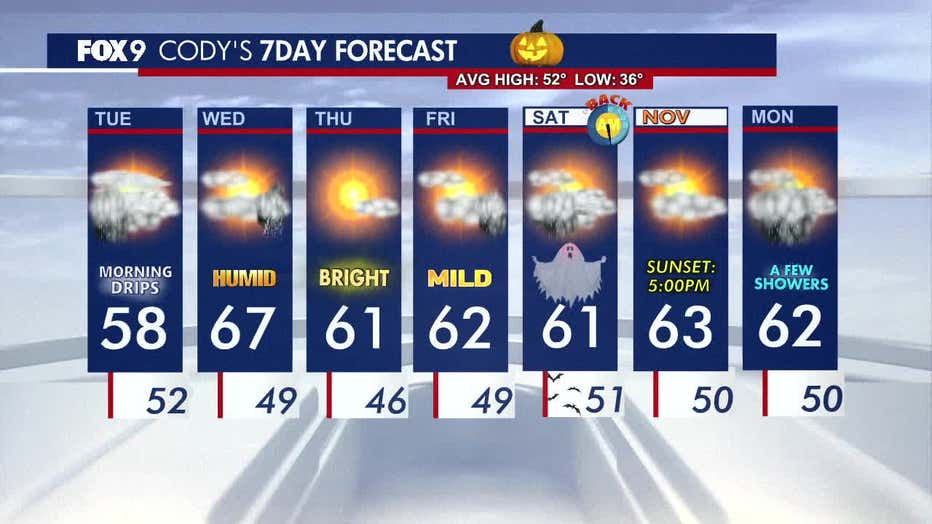
(FOX 9)
The Source: This story uses information from FOX 9 meteorologists.