

Minnesota weather: Two rounds of scattered storms possible Wednesday
MN weather: Wednesday evening forecast update
FOX 9 meteorologist Jared Piepenburg has the latest forecast details.
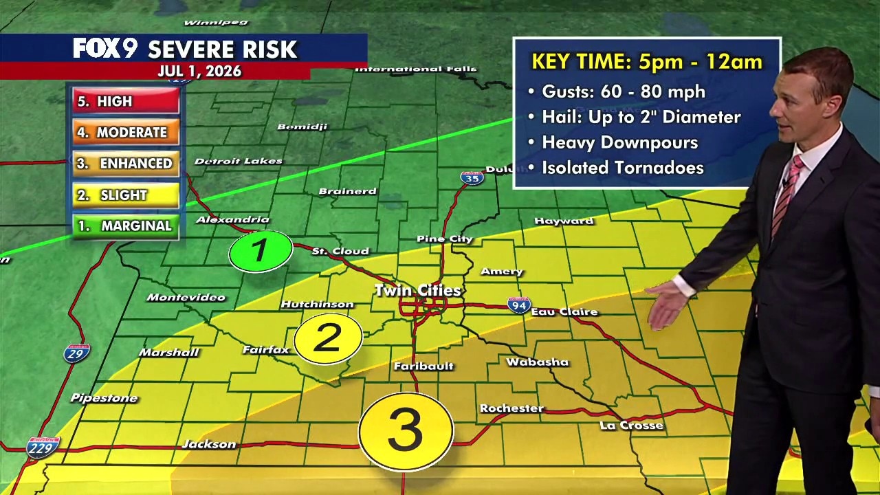
MINNEAPOLIS (FOX 9) - Minnesota is in for a warm, muggy Wednesday with two rounds of possible storms. The Twin Cities metro is under a level 2 slight risk for severe weather, while southeastern Minnesota is under a level 3 enhanced risk.
Wednesday’s forecast in Minnesota
The forecast:
Wednesday starts with a round of showers and thunderstorms moving across Minnesota. While these morning storms are not expected to be severe, they could produce frequent lightning, heavy downpours, and gusty winds.
Storms move out by late morning, leading to a quieter stretch through much of the afternoon. Temperatures climb into the 80s statewide, with the Twin Cities metro expected to reach around 84 degrees. Humidity remains high, making for another muggy day.
Overnight lows fall to around 70 degrees in the Twin Cities metro, while northern Minnesota cools into the upper 50s and low 60s.

Severe storm chances Wednesday evening
What to expect:
Another round of thunderstorms is expected to redevelop late this afternoon and evening, though the exact placement and coverage will depend on how quickly this morning's storms move out. Storms are most likely between 5 p.m. and 10 p.m. in the Twin Cities metro and 5 p.m. to midnight across the FOX 9 viewing area.
The storms will likely start isolated or in small clusters, leading to a large hail and tornado threat early, before congealing into large clusters or small lines, which will increase the strong wind threat, as storms slowly drop south or east of the area after midnight.
Any areas where the storms linger a little while, or get multiple rounds, will have flash flood potential as rainfall rates could top 2 or 3 inches an hour in the stronger storms.
Severe storm risk:
The Twin Cities metro has been downgraded to a level 2 slight risk of severe weather, while southeastern Minnesota remains at a level 3 enhanced risk.
The primary hazards include hail between 1 and 2 inches in diameter, wind gusts of 60 to 80 mph. Torrential downpours and isolated tornadoes are also possible.

Extended Minnesota weather forecast
What's next:
Thursday looks mostly quiet, hot, and humid, with highs near 90 degrees. Another round of showers and thunderstorms could move out of the Dakotas Thursday night into Friday morning.
The Fourth of July on Saturday currently looks mostly dry, though an isolated thunderstorm can't be ruled out. Temperatures remain warm in the mid to upper 80s through the holiday weekend and into next week.
Here's a look at the seven-day forecast:

The Source: This forecast uses information from FOX 9 meteorologists.