

Historic storm could form in the Gulf of Mexico this week; earliest named storm since 2017
Six of the last seven hurricane seasons have seen a named tropical system form in the month of May, but April? Well, that’s extremely rare!
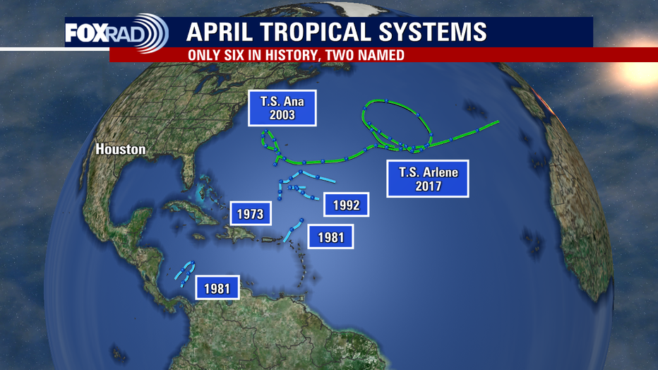
According to National Hurricane Center records, only two named tropical systems occurred in April - Ana in 2003 and Arlene in 2017. Neither of those tropical storms impacted land as Ana made a long trek across the Atlantic Ocean away from the United States and Arlene simply spun around the central Atlantic for one day.
DOWNLOAD THE FOX 26 HOUSTON APP BY CLICKING HERE
There have been a few very small and poorly documented tropical depressions during the month of April, but most certainly, organized tropical systems are exceedingly rare and none have occurred in the Gulf of Mexico.
A complex pattern this week involves an unusual orientation of the jet stream which is becoming pinched near the Texas coast. This will likely create what is called a "cutoff low".
Lows like this aren’t uncommon, but the location of this one is and, although its spin is occurring at around 20k feet above the ground, it could help to create a low at the surface.R
RELATED: Hurricane Preps
Given the water temperatures in the low 70s, this would not likely be a purely tropical low but still could be feisty with gusty winds and heavy rain from Louisiana to Florida. It remains to be seen how the National Hurricane Center will handle the naming of this odd system, but it may be designated a "subtropical depression" or a "subtropical storm".
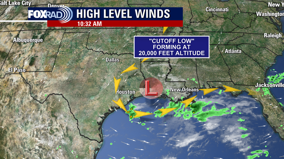
The decision would have to be made whether the area of low pressure is a "warm core", meaning a tropical system that feeds off of warm water, or a "cold core" system, more like the lows that bring cold fronts.

Rare tropic-like system could in the Gulf this week; earliest named storm since 2017
According to National Hurricane Center records, only two named tropical systems occurred in April - Ana in 2003 and Arlene in 2017. Neither of those tropical storms impacted land as Ana made a long trek across the Atlantic Ocean away from the United States and Arlene simply spun around the central Atlantic for one day.
Hybrid storms can and do happen, but even those are nearly unknown in recent memory in the Gulf of Mexico.
MORE: HOUSTON WEATHER ALERTS
In another strange twist of fate, the first name on this year’s list is Arlene - yes, the same name as the last tropical storm to form in April (names recycle every six years unless retired)!
Whatever forms, and it could stay a non-tropical system, it would likely have minimal effects on Texas.
Pockets of heavy rain could impact an area from Louisiana to Florida.
The Atlantic hurricane season officially begins on June 1 and ends on November 30.
However, there has been a discussion about whether the start date should be moved ahead to May 15.
As of Wednesday morning, the expectations for a hybrid-tropical system remain complicated. On one hand, this low seems to be building strength and taking on more of a tropical "look". On another hand, it may not meet the exact definition of a subtropical depression from the National Weather Service.
Here is their technical definition:
Subtropical Cyclone:
A non-frontal low-pressure system that has characteristics of both tropical and extratropical cyclones. Like tropical cyclones, they are non-frontal, synoptic-scale cyclones that originate over tropical or subtropical waters, and have a closed surface wind circulation about a well-defined center.
In contrast to their technical definition, Hurricane Martin formed in late October last year and was undoubtedly a "frontal" system, meaning attached to a cold/stationary front, but still got a name. For this reason, I think we can't dismiss the possibility of this system briefly receiving the "subtropical depression" label.
The opposing point of view is that there is a large "upper-level, cutoff" low over the Texas-Louisiana state line. It's this low high in the atmosphere that is mostly responsible for the low in the Gulf. Also, the Gulf low is clearly attached to a cold and warm front, so that is a counterargument.
However this turns out, heavy downpours and gusty winds are possible from Louisiana to Florida for the next few days.