


Active weather day continues Tuesday
It?s been an active weather day on highways, byways and roads throughout the Twin Cities on Tuesday as most major roads are still offering slow commutes despite continued plowing efforts. Most areas in the metro are sitting with more than four inches of fresh snow. The wind doesn?t help conditions, as its 30+ mph gusts add to the cold and reduce visibility.
It?s been an active weather day on highways, byways and roads throughout the Twin Cities on Tuesday as most major roads are still offering slow commutes despite continued plowing efforts. Most areas in the metro are sitting with more than four inches of fresh snow. The wind doesn?t help conditions, as its 30+ mph gusts add to the cold and reduce visibility.

Tuesday's (lunchtime) forecast: Winter Weather Advisory through 6pm
It's snowy and windy, but should stop around 6 pm. Totals in the metro should remain around 3-5 inches.
It's snowy and windy, but should stop around 6 pm. Totals in the metro should remain around 3-5 inches.

Snow set to move into Twin Cities metro on Tuesday
Snow flurries are expecting to wind up overnight bringing several inches of snow to the Twin Cities metro by the end of Tuesday.
Snow flurries are expecting to wind up overnight bringing several inches of snow to the Twin Cities metro by the end of Tuesday.

Monday's forecast: Snow up north, possible in the metro
Tuesday should be snowy with several inches possible.
Tuesday should be snowy with several inches possible.
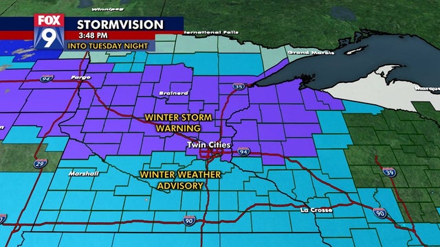

Snow in forecast for Twin Cities after Sunday warm-up
The Twin Cities metro is on the edge of the Winter Storm Warning in place for central Minnesota.
The Twin Cities metro is on the edge of the Winter Storm Warning in place for central Minnesota.

After sunny Sunday, snow in the forecast for Twin Cities
After a warmup on Sunday, get ready for some snow over the next few days.
After a warmup on Sunday, get ready for some snow over the next few days.
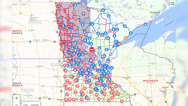

White-out conditions cause crashes, closures throughout Minnesota
Commuters traveling through central and northwestern Minnesota are advised to take caution as weather Friday into Saturday morning will present near white-out conditions.
Commuters traveling through central and northwestern Minnesota are advised to take caution as weather Friday into Saturday morning will present near white-out conditions.

Friday's forecast: High above freezing!
Snow possible midday and temps will fall throughout the day.
Snow possible midday and temps will fall throughout the day.

Thursday's forecast: Big changes blowing in
What to expect this weekend? A windy Friday, cool Saturday, and warm Sunday.
What to expect this weekend? A windy Friday, cool Saturday, and warm Sunday.

Thursday's forecast: A cold one with highs around 10
The temperature rollercoaster continues as a low below zero today rises to a high above 35 Friday. Also, snow is possible tomorrow.
The temperature rollercoaster continues as a low below zero today rises to a high above 35 Friday. Also, snow is possible tomorrow.

Wednesday's forecast: Highs around the mid 20s
Overnight gets much colder as Thursday's lows will be around 0.
Overnight gets much colder as Thursday's lows will be around 0.

Tuesday's forecast: Warmer with highs near 30
Colder air returns Wednesday and Thursday.
Colder air returns Wednesday and Thursday.

Monday's forecast: A chilly Valentine's day with temps around 10 degrees below average
Highs Tuesday should be around 30.
Highs Tuesday should be around 30.

Light snow creating slick roads overnight
Light snowfall on Sunday night is turning roads in the Twin Cities icy, making for slick travel.
Light snowfall on Sunday night is turning roads in the Twin Cities icy, making for slick travel.
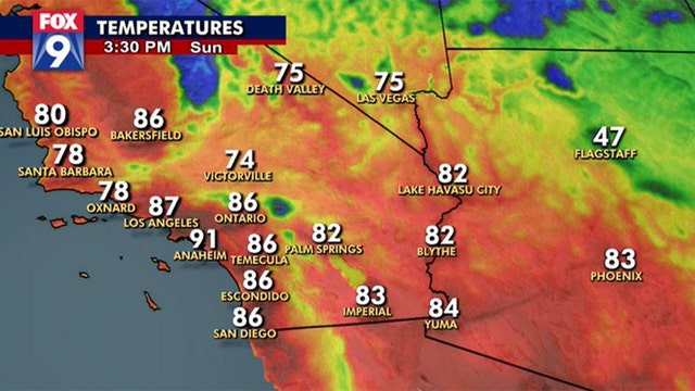

Super Bowl could be hottest on record while Minnesota enters the deep freeze
Super Bowl 56 has a good chance to be the warmest Super Bowl ever played - 80 degrees warmer than the Twin Cities at kickoff.
Super Bowl 56 has a good chance to be the warmest Super Bowl ever played - 80 degrees warmer than the Twin Cities at kickoff.

Friday's forecast: A warm start, but temps fall throughout the day
Below zero overnight with a high Saturday around 7.
Below zero overnight with a high Saturday around 7.

Another freeze coming for the weekend
Minnesota is set to get blasted with another round of arctic cold this weekend.
Minnesota is set to get blasted with another round of arctic cold this weekend.

Thursday's forecast: Seasonable start with snow possible this afternoon
After the snow rolls through, the cold arrives.
After the snow rolls through, the cold arrives.

Wednesday's forecast: After a warm Tuesday, temps will slide back below freezing
Tomorrow will warm slightly and bring temps to the mid 30s.
Tomorrow will warm slightly and bring temps to the mid 30s.

Tuesday's forecast: Above freezing!!!!!!!!
Around 40 degrees for a high with a good deal of sun.
Around 40 degrees for a high with a good deal of sun.