


Friday's forecast: Sunny with highs in 20s
Saturday will see highs above freezing in the metro.
Saturday will see highs above freezing in the metro.

Thursday afternoon forecast: Slippery roads possible tonight
A wintry mix to snow is possible Thursday, which could make roads slippery Thursday evening. Cooler temperatures overnight, with highs in the 20s on Friday. Warmth returns for the weekend, with highs in the 30s. Light snow is possible Saturday evening.
A wintry mix to snow is possible Thursday, which could make roads slippery Thursday evening. Cooler temperatures overnight, with highs in the 20s on Friday. Warmth returns for the weekend, with highs in the 30s. Light snow is possible Saturday evening.

Thursday forecast: Cloudy and a little damp
Cloudy and a little damp with patchy drizzle becoming more of a light rain to light snow later Thursday afternoon and into the evening. Watch for evolving slippery spots for the afternoon commute as up to an inch of snow is possible by 9 p.m. Bright and seasonable 20s on Friday.
Cloudy and a little damp with patchy drizzle becoming more of a light rain to light snow later Thursday afternoon and into the evening. Watch for evolving slippery spots for the afternoon commute as up to an inch of snow is possible by 9 p.m. Bright and seasonable 20s on Friday.

Wednesday's forecast: Highs in the 30s
The thaw is underway, with high temperatures in the mid-30s on Wednesday. Highs will continue to stay in the 30s into next week. Things will stay pretty quiet, but there is potential for rain or freezing drizzle Wednesday night and Thursday.
The thaw is underway, with high temperatures in the mid-30s on Wednesday. Highs will continue to stay in the 30s into next week. Things will stay pretty quiet, but there is potential for rain or freezing drizzle Wednesday night and Thursday.

Tuesday's forecast: Seasonable highs in the 20s
We're crawling out of the deep freeze on Tuesday, with more seasonable temperatures in the 20s on Tuesday. Looking ahead to this week, the warmer temperatures continue, with highs in the mid-30s Wednesday and Thursday.
We're crawling out of the deep freeze on Tuesday, with more seasonable temperatures in the 20s on Tuesday. Looking ahead to this week, the warmer temperatures continue, with highs in the mid-30s Wednesday and Thursday.
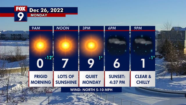

Quiet after the storm: All ‘No Travel’ advisories lifted throughout Minnesota
The precipitation has finally cleared and a cold calm has set in - allowing all remaining ‘No Travel’ advisories from the Minnesota Department of Transportation (MnDOT) to be cleared.
The precipitation has finally cleared and a cold calm has set in - allowing all remaining ‘No Travel’ advisories from the Minnesota Department of Transportation (MnDOT) to be cleared.

Sunday forecast: Snow possible on Christmas Day
Parts of the metro and southwestern Minnesota could see some accumulating snow throughout the day on Sunday. Temperatures will remain well below average with a high of 6 degrees and feels like temperatures below zero.
Parts of the metro and southwestern Minnesota could see some accumulating snow throughout the day on Sunday. Temperatures will remain well below average with a high of 6 degrees and feels like temperatures below zero.

Saturday forecast: Frigid temps and gusty winds
Saturday will be bitterly cold with a high of 2 degrees, but the feels like temperatures are staying well below zero. Winds are still strong, with 30 mph gusts possible, which should calm down by tonight.
Saturday will be bitterly cold with a high of 2 degrees, but the feels like temperatures are staying well below zero. Winds are still strong, with 30 mph gusts possible, which should calm down by tonight.

Winter road conditions remain icy
Wind and snow are creating treacherous snow conditions on many roads throughout Minnesota Friday evening. FOX 9?s Theo Keith has the latest.
Wind and snow are creating treacherous snow conditions on many roads throughout Minnesota Friday evening. FOX 9?s Theo Keith has the latest.
![Friday's forecast [11:30 a.m.]: Whiteout conditions, blowing snow in Minnesota](https://static-media.fox.com/fmcv3/prod/fts/A-762694/64iv333ftnxji4q6.jpg)
Friday's forecast [11:30 a.m.]: Whiteout conditions, blowing snow in Minnesota
Blizzard conditions are setting up across parts of western and southern Minnesota, and it could continue expanding north and eastward as winds are still likely to increase further as the day progresses. Temperatures remain frigid into Saturday.
Blizzard conditions are setting up across parts of western and southern Minnesota, and it could continue expanding north and eastward as winds are still likely to increase further as the day progresses. Temperatures remain frigid into Saturday.

Friday's forecast: Dangerously cold; blowing and drifting snow
A bright day ahead, but dangerously cold with very gusty breezes creating significant blowing and drifting snow. Expect some lower visibility at times, especially in open areas, as travel across the area is largely discouraged.
A bright day ahead, but dangerously cold with very gusty breezes creating significant blowing and drifting snow. Expect some lower visibility at times, especially in open areas, as travel across the area is largely discouraged.

Minnesota weather: Winds pick up Thursday night, blowing snow, impacting travel
After getting dumped on with snow Wednesday, cold temperatures and wind -- blowing that snow -- will be the main risks
After getting dumped on with snow Wednesday, cold temperatures and wind -- blowing that snow -- will be the main risks
![Thursday's forecast [11 a.m.]: Winds increase late Thursday; blizzard warnings issued](https://static-media.fox.com/fmcv3/prod/fts/A-762699/twmzsoo6szt44nb7.jpg)
Thursday's forecast [11 a.m.]: Winds increase late Thursday; blizzard warnings issued
Travel could be very difficult if not impossible Thursday night through Saturday morning due to winds blowing around the light, fluffy snow that fell on Wednesday. Travel is not advised in the blizzard warning zones over the next 48 hours.
Travel could be very difficult if not impossible Thursday night through Saturday morning due to winds blowing around the light, fluffy snow that fell on Wednesday. Travel is not advised in the blizzard warning zones over the next 48 hours.

Thursday's forecast: Lull ahead of blizzard-like conditions tonight
After snow on Wednesday, there will be a lull for much of the day on Thursday. But blizzard-like conditions are expected Thursday night through Saturday morning. A blizzard warning goes into effect for much of southwestern Minnesota as well as a portion of the southwest metro.
After snow on Wednesday, there will be a lull for much of the day on Thursday. But blizzard-like conditions are expected Thursday night through Saturday morning. A blizzard warning goes into effect for much of southwestern Minnesota as well as a portion of the southwest metro.

Minnesota weather: Increasing winds will plunge parts of metro into blizzard warning starting Thursday
High winds that will pick up on Thursday will plunge parts of the Twin Cities metro, and areas to the west and south, into a blizzard warning starting Thursday.
High winds that will pick up on Thursday will plunge parts of the Twin Cities metro, and areas to the west and south, into a blizzard warning starting Thursday.
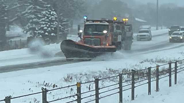

Minneapolis, St. Paul and other cities declare snow emergencies
With measurable snow amounts expected to fall throughout most of the state and the entire metro region from Wednesday to Saturday morning, snow emergency parking restrictions have been declared in effect for numerous cities throughout the metro region.
With measurable snow amounts expected to fall throughout most of the state and the entire metro region from Wednesday to Saturday morning, snow emergency parking restrictions have been declared in effect for numerous cities throughout the metro region.
![Wednesday afternoon forecast [2:30 p.m.]: Dangerous travel likely Thursday-Friday](https://static-media.fox.com/fmcv3/prod/fts/hc6lemlrfw5i7k8u/lyjtnrphs0o45pd6.jpg)
Wednesday afternoon forecast [2:30 p.m.]: Dangerous travel likely Thursday-Friday
Snow that falls on Wednesday will blow around on Thursday and Friday thanks to gusty winds. This will create dangerous travel conditions, so expect delays and rough road conditions.
Snow that falls on Wednesday will blow around on Thursday and Friday thanks to gusty winds. This will create dangerous travel conditions, so expect delays and rough road conditions.

Wednesday's forecast: Snowy and cold; blizzard-like conditions Thursday
White-out conditions are likely in southwestern Minnesota Thursday through early Saturday as winds kick up and blow the snow around.
White-out conditions are likely in southwestern Minnesota Thursday through early Saturday as winds kick up and blow the snow around.

Wednesday's forecast: Snow Wednesday, blizzard or blizzard-like conditions to follow
Snow will arrive in the Twin Cities in the late morning. Strong winds on Thursday will blow snow around, creating blizzard or blizzard-like conditions across the area. Temperatures will be subzero.
Snow will arrive in the Twin Cities in the late morning. Strong winds on Thursday will blow snow around, creating blizzard or blizzard-like conditions across the area. Temperatures will be subzero.

Minnesota weather: Snowstorm to create dangerous travel conditions across the Midwest this week
Get ready. The next few days are going to be tough in Minnesota and across the Midwest.
Get ready. The next few days are going to be tough in Minnesota and across the Midwest.