


Spring has sprung in Minnesota
As the semester nears its end at the University of Minnesota, some are still studying for finals, while others are just happy to soak up the sun.
As the semester nears its end at the University of Minnesota, some are still studying for finals, while others are just happy to soak up the sun.


Minnesota weather: Pleasant Tuesday, storm chances return Wednesday, Thursday
A very pleasant Tuesday is in store after a hot and stormy Monday. But the heat, humidity and chances for storms return Wednesday and Thursday.
A very pleasant Tuesday is in store after a hot and stormy Monday. But the heat, humidity and chances for storms return Wednesday and Thursday.

Tuesday's forecast: Very pleasant with highs in the 70s
More heat and humidity tomorrow, but it will be another lovely day.
More heat and humidity tomorrow, but it will be another lovely day.

Monday night weather: Nice weather followed by storms for week ahead
Tuesday is shaping up to be a beautiful day but, after some storms on Monday, more are in the forecast for the week ahead.
Tuesday is shaping up to be a beautiful day but, after some storms on Monday, more are in the forecast for the week ahead.

Minnesota weather: Storms move in Monday evening
A tornado watch is in effect for Monday evening as Minnesota braces for another round of storms. Ian Leonard has your forecast.
A tornado watch is in effect for Monday evening as Minnesota braces for another round of storms. Ian Leonard has your forecast.


Fire danger remains high across Wisconsin and Minnesota officials warn
Following a busy weekend of fire activity across both states, both the Minnesota and Wisconsin Department of Natural Resources (DNR) are asking the public to remain vigilant and avoid burning as fire dangers remain high.
Following a busy weekend of fire activity across both states, both the Minnesota and Wisconsin Department of Natural Resources (DNR) are asking the public to remain vigilant and avoid burning as fire dangers remain high.

Monday's forecast: Storms possible with highs in the 80s
Western Minnesota is most likely to see severe weather. Highs in the low 80s or high 70s.
Western Minnesota is most likely to see severe weather. Highs in the low 80s or high 70s.


Minnesota weather: Cool and cloudy before the big warm up
A cool and cloudy Mother's Day. On the bright side, our rain chances diminish throughout the day. Things really change heading into Monday as we crank up the heat in a big way!
A cool and cloudy Mother's Day. On the bright side, our rain chances diminish throughout the day. Things really change heading into Monday as we crank up the heat in a big way!

Saturday's forecast: Lots of sunshine
A beautiful day with clear skies and highs in the 70s!
A beautiful day with clear skies and highs in the 70s!


Weekend weather: Stunner Friday, a few showers possible on Mother's Day
There will be plenty of sunshine on Friday and Saturday, but Mother's Day is looking a bit unsettled.
There will be plenty of sunshine on Friday and Saturday, but Mother's Day is looking a bit unsettled.

Friday's forecast: It'll be a nice one!
Highs around 70 today, more of the same for Derby Day!
Highs around 70 today, more of the same for Derby Day!


Minnesota weather: Our green-up begins
Our much-anticipated green-up is about to get a swift kick into high gear.
Our much-anticipated green-up is about to get a swift kick into high gear.

Thursday's forecast: Cloudy with seasonable temps
Friday looks to be sunny with highs in the mid 60s.
Friday looks to be sunny with highs in the mid 60s.

Minnesota weather: High 70s possible early next week
Highs in the low 60s on Wednesday, temps in the upper 70s possible by early next week.
Highs in the low 60s on Wednesday, temps in the upper 70s possible by early next week.


Minnesota weather: Warming trend continues, upper 70s possible next week
Saturday is looking glorious.
Saturday is looking glorious.
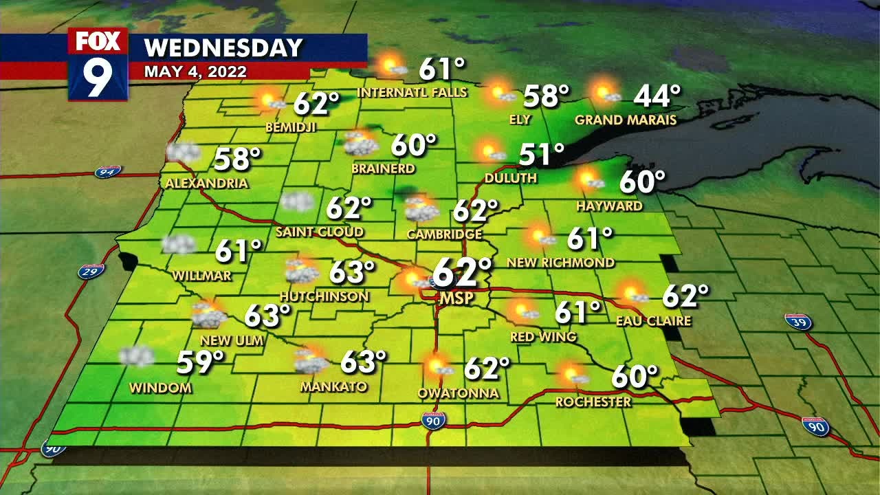
Wednesday's forecast: Highs in the low 60s!
Warming trend continues through the rest of the week.
Warming trend continues through the rest of the week.

Tuesday night weather: Finally feels like spring
After a miserable start to the season, some sun and warmer temps made Tuesday feel a little like spring.
After a miserable start to the season, some sun and warmer temps made Tuesday feel a little like spring.

Minnesota weather: Sunshine, seasonable temperatures this week
Seasonable temperatures return Wednesday, with sunshine in store for the rest of the week.
Seasonable temperatures return Wednesday, with sunshine in store for the rest of the week.


Minnesota weather: Seasonable temperatures in store this week
Things will get warmer this week, with seasonable temperatures expected by Wednesday.
Things will get warmer this week, with seasonable temperatures expected by Wednesday.

Monday's forecast: Highs in the low 50s
Temps warm throughout the week with 70s possible on Sunday.
Temps warm throughout the week with 70s possible on Sunday.