


Wednesday's forecast: Midday sun with storms possible this afternoon
Thursday could also see some severe storms
Thursday could also see some severe storms

Tuesday night weather: Rumbling rain overnight follows perfect day
Some storms follow a perfect Tuesday.
Some storms follow a perfect Tuesday.

Minnesota weather: Storms possible Wednesday, Thursday
We may see the occasional drip in the Twin Cities metro Tuesday night. Things clear up on Wednesday but there may be a random rumble of thunder late in the day. Stronger storms are possible Thursday afternoon.
We may see the occasional drip in the Twin Cities metro Tuesday night. Things clear up on Wednesday but there may be a random rumble of thunder late in the day. Stronger storms are possible Thursday afternoon.


Minnesota weather: Rain possible Tuesday, Wednesday
Clouds will increase today, with showers possible tonight. Here's your forecast.
Clouds will increase today, with showers possible tonight. Here's your forecast.

Tuesday's forecast: Sunny with scattered rain possible
Rain rolls in to the metro around 6 or 7 this evening.
Rain rolls in to the metro around 6 or 7 this evening.

Monday's mid-day forecast: Plenty of sun!
Highs in the low 70s, temps drop into the 40s overnight.
Highs in the low 70s, temps drop into the 40s overnight.
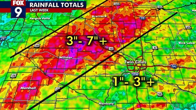

Water levels on Minnesota rivers climbing amid wet start to May
It looks like some high water is in the cards for at least the next couple of weeks.
It looks like some high water is in the cards for at least the next couple of weeks.

Monday's forecast: Sunny with highs in the lower 70s
More sun tomorrow with highs in the mid-60s.
More sun tomorrow with highs in the mid-60s.


Minnesota weather: Gorgeous weekend ahead with plenty of sunshine
This weekend is looking simply gorgeous.
This weekend is looking simply gorgeous.

Minnesota weather: Gorgeous weekend with plenty of sunshine
After a stormy week and record high temps on Thursday, it's shaping up to be a gorgeous weekend weather-wise with temperatures in the 70s and plenty of sunshine.
After a stormy week and record high temps on Thursday, it's shaping up to be a gorgeous weekend weather-wise with temperatures in the 70s and plenty of sunshine.

Friday's forecast: Partly sunny in the high 70s!
Thursday night's storms have blown out the heat & humidity and set the stage for a pleasant weekend ahead.
Thursday night's storms have blown out the heat & humidity and set the stage for a pleasant weekend ahead.


Minnesota weather: Severe storms sweep through state
Severe storms have left behind damage across the state for the second night in a row.
Severe storms have left behind damage across the state for the second night in a row.


Minnesota weather: Severe storms roll through Twin Cities metro
A tornado watch is in effect Wednesday evening until midnight for much of southern and central Minnesota and parts of western Wisconsin.
A tornado watch is in effect Wednesday evening until midnight for much of southern and central Minnesota and parts of western Wisconsin.

Minnesota weather: Strong storms possible Thursday night
The storms will gradually weaken as they move from western to eastern Minnesota. Stay sky aware, as storms are expected to reach the Twin Cities after sunset.
The storms will gradually weaken as they move from western to eastern Minnesota. Stay sky aware, as storms are expected to reach the Twin Cities after sunset.

Thursday's forecast: Hot and humid with storms possible overnight
Friday will be another warm one with a high near 80.
Friday will be another warm one with a high near 80.

Twin Cities region sees intense storms
FOX 9 reporter Babs Santos was onsite in Jordan, Minnesota, Wednesday night to offer a live weather report – capturing amazing footage in the process.
FOX 9 reporter Babs Santos was onsite in Jordan, Minnesota, Wednesday night to offer a live weather report – capturing amazing footage in the process.

Wednesday evening weather: Strong storms expected
After a busy weather week already, another round of storms are set to move through Minnesota and the Twin Cities metro on Wednesday.
After a busy weather week already, another round of storms are set to move through Minnesota and the Twin Cities metro on Wednesday.

Minnesota weather: Severe weather threat Wednesday evening
The threat of severe weather blossoms Wednesday night, and tappers off after midnight. Thursday will be hotter and steamier, with highs around 90 degrees. The threat for severe weather returns Thursday evening.
The threat of severe weather blossoms Wednesday night, and tappers off after midnight. Thursday will be hotter and steamier, with highs around 90 degrees. The threat for severe weather returns Thursday evening.

Wednesday's forecast: Hotter today with severe storms possible later this evening
Thursday will be another hot one with temps in the 90s.
Thursday will be another hot one with temps in the 90s.

Spring has sprung in Minnesota
As the semester nears its end at the University of Minnesota, some are still studying for finals, while others are just happy to soak up the sun.
As the semester nears its end at the University of Minnesota, some are still studying for finals, while others are just happy to soak up the sun.