


Minnesota weather: Summer-like weather returns just in time for the long holiday weekend
The heat and humidity will make way for some storms, which could turn severe. Here's your forecast.
The heat and humidity will make way for some storms, which could turn severe. Here's your forecast.

Minnesota weather: Sunshine and high of 77 degrees on Friday
The sunshine returns Friday, with a high of 77 degrees in the Twin Cities. The high Saturday is in the 80s for much of Minnesota, while it'll be cooler in north-central and northeastern Minnesota. It'll be hot and steamy on Sunday, with highs in the mid-80s and plenty of humidity, which could lead to some isolated storms. Memorial Day will see highs approaching 90 degrees.
The sunshine returns Friday, with a high of 77 degrees in the Twin Cities. The high Saturday is in the 80s for much of Minnesota, while it'll be cooler in north-central and northeastern Minnesota. It'll be hot and steamy on Sunday, with highs in the mid-80s and plenty of humidity, which could lead to some isolated storms. Memorial Day will see highs approaching 90 degrees.

Minnesota weather: Highs in 60s on Thursday, 70s on Friday
The warmup is underway, with highs in the 60s on Thursday, followed by the mid-70s on Friday. It'll heat up into the 80s for the weekend, and then the high is 91 degrees on Memorial Day.
The warmup is underway, with highs in the 60s on Thursday, followed by the mid-70s on Friday. It'll heat up into the 80s for the weekend, and then the high is 91 degrees on Memorial Day.


Minnesota weather: Here's what could be in store over the summer
It could be a very warm summer in Minnesota.
It could be a very warm summer in Minnesota.

Thursday's forecast: Clouds linger through most of the day, highs around 70
Friday will be sunny with highs in the mid 70s!
Friday will be sunny with highs in the mid 70s!

Minnesota weather: Rain will be hit and miss Wednesday afternoon
After a wet morning, rain showers will become of the hit-and-miss variety Wednesday afternoon and night. Thursday will start off cloudy, but skies will clear with highs climbing into the 60s. Looking at the holiday weekend, temps will be in the upper 70s and 80s.
After a wet morning, rain showers will become of the hit-and-miss variety Wednesday afternoon and night. Thursday will start off cloudy, but skies will clear with highs climbing into the 60s. Looking at the holiday weekend, temps will be in the upper 70s and 80s.
Wednesday's forecast: Rain, a lot of rain
Showers will lessen by Wednesday evening making for a warmer, drier Thursday.
Showers will lessen by Wednesday evening making for a warmer, drier Thursday.

Minnesota weather: Rainy Wednesday ahead
A windy and rainy Wednesday is ahead for Minnesota. Ian Leonard has your forecast.
A windy and rainy Wednesday is ahead for Minnesota. Ian Leonard has your forecast.


Minnesota weather: Wet, chilly Wednesday, with an inch or more of rain possible
Widespread rain is expected Wednesday, with highs in the 50s.
Widespread rain is expected Wednesday, with highs in the 50s.

Tuesday's forecast: Dry with occasional clouds, highs in the upper 60s
Rain will arrive overnight and stick around most of Wednesday.
Rain will arrive overnight and stick around most of Wednesday.


Minnesota forecast: Warmer for Memorial Day weekend
Monday will be warmer with patchy clouds building into the afternoon. And the forecast is looking promising for Memorial Day weekend.
Monday will be warmer with patchy clouds building into the afternoon. And the forecast is looking promising for Memorial Day weekend.

Minnesota weather: Highs in the 60s; cool, wet Wednesday
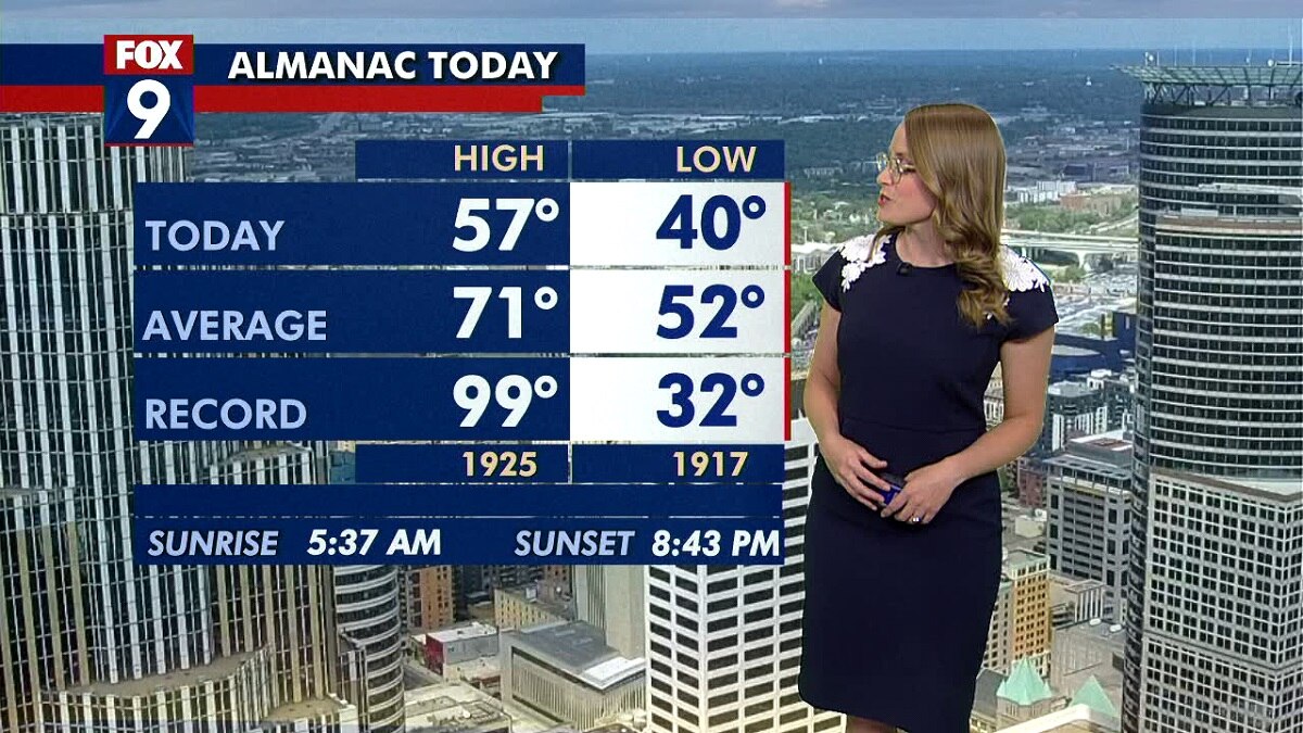
Fresh clouds build Monday with highs in the mid-60s. Monday night will be cloudy and cool, with a low of 48 degrees in the Twin Cities. Tuesday will be pleasant enough with a high of 67 and patchy clouds. Wednesday's high is in the 50s with rain in the forecast.
Fresh clouds build Monday with highs in the mid-60s. Monday night will be cloudy and cool, with a low of 48 degrees in the Twin Cities. Tuesday will be pleasant enough with a high of 67 and patchy clouds. Wednesday's high is in the 50s with rain in the forecast.

Weather forecast: Milder temps, increasing clouds on Monday
High temps will top out in the mid-60s in the Twin Cities, with increasing clouds throughout the day. Overnight lows on Monday will be cooler than average in the upper 40s. Tuesday will see highs in the upper 60s, and Wednesday will be cool and wet. The holiday weekend brings a warming trend.
High temps will top out in the mid-60s in the Twin Cities, with increasing clouds throughout the day. Overnight lows on Monday will be cooler than average in the upper 40s. Tuesday will see highs in the upper 60s, and Wednesday will be cool and wet. The holiday weekend brings a warming trend.
Sunday weather: More mild weather
Cooler temperatures are staying into effect on Sunday.
Cooler temperatures are staying into effect on Sunday.

Weekend forecast: 'May chilly' Saturday, sunny on Sunday in Minnesota
A chilly weekend is in store this weekend in Minnesota. Highs on Friday top out in the upper 60s in the Twin Cities, followed by a high of 55 on Saturday. Sunday is looking sunny with a high of around 60 degrees.
A chilly weekend is in store this weekend in Minnesota. Highs on Friday top out in the upper 60s in the Twin Cities, followed by a high of 55 on Saturday. Sunday is looking sunny with a high of around 60 degrees.

Minnesota weather: Cooler Friday, even chillier weekend
Rain showers move out Friday morning, with partly cloudy skies by the afternoon. High temps will be in the 60s.
Rain showers move out Friday morning, with partly cloudy skies by the afternoon. High temps will be in the 60s.

Thursday afternoon update: Severe weather threat in southern MN
Strong to severe storms are possible Thursday afternoon and evening, especially in southeastern Minnesota.
Strong to severe storms are possible Thursday afternoon and evening, especially in southeastern Minnesota.

Minnesota weather: Strong to severe storms possible Thursday
Scattered storms are expected in central and southeastern Minnesota Thursday afternoon, with southeast Minnesota and western Wisconsin having the best chance of seeing strong storms. The main threats with strong storms that do develop are large hail and gusty winds.
Scattered storms are expected in central and southeastern Minnesota Thursday afternoon, with southeast Minnesota and western Wisconsin having the best chance of seeing strong storms. The main threats with strong storms that do develop are large hail and gusty winds.

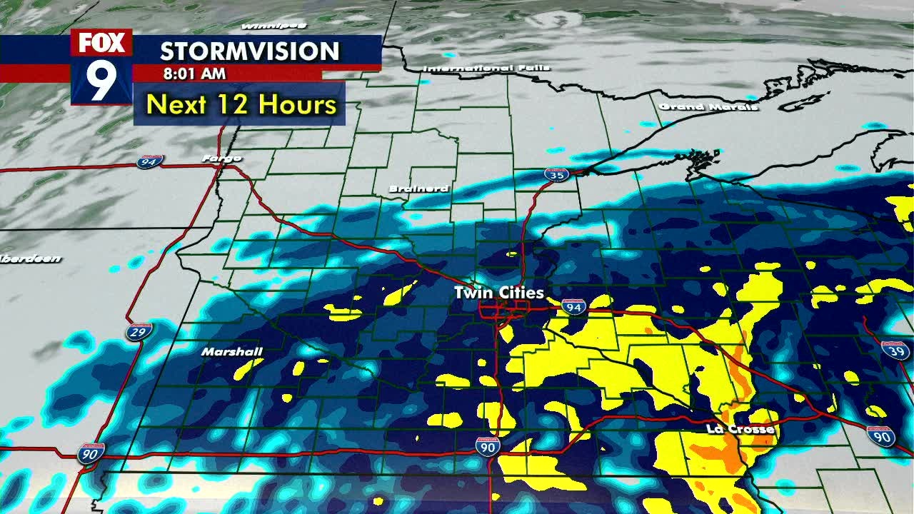
Minnesota weather: Isolated storms Wednesday, strong storms possible Thursday
Isolated storms are possible Wednesday, especially in northern Minnesota. A warm front will bring warmer temps Thursday to half the state. Strong to severe storms are possible Thursday, including in the Twin Cities. A much cooler weekend is expected.
Isolated storms are possible Wednesday, especially in northern Minnesota. A warm front will bring warmer temps Thursday to half the state. Strong to severe storms are possible Thursday, including in the Twin Cities. A much cooler weekend is expected.


Minnesota weather: Warm, unsettled week turns chilly and potentially frosty this weekend
Scattered storms are possible Wednesday and Thursday. Then, we get the big cool down.
Scattered storms are possible Wednesday and Thursday. Then, we get the big cool down.