

MN wildfires closing access to part of Gunflint Ranger District
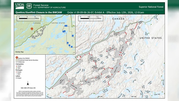
Image shared by The U.S. Department of Agriculture Forest Service shows which lakes and associated campsites are closed because of wildfires in the area. (Supplied)
(FOX 9) - Authorities announced more public access closures in response to wildfires in the Minnesota Boundary Waters Canoe Area Wilderness (BWCAW).
READ MORE: Multiple active wildfires burning in Superior National Forest
Wildfire emergency closures
Local perspective:
The U.S. Department of Agriculture Forest Service is closing public access to the northwestern portion of the Gunflint Ranger District in response to a wildfire in Quetico Provincial Park.
The following lakes and associated campsites are closing due to the emergency order:
- Ottertrack Lake
- Little Knife Lake
- Amoeber Lake
- Topaz Lake
- Cherry Lake
- Hanson Lake
- Ester Lake
- Rabbit Lake
- Clam Lake
- Ashdick Lake
- Swamp Lake
- Gijikiki Lake
- Rivalry Lake
- Lake of the Clouds
- Lunar Lake
More information can be found here.
The backstory:
The following entry points were closed in response to wildfires on Friday.
- Angleworm Lake (OP) #20
- Angleworm Trail (OH) #21
- Blandin Trail (OH) #11
- Herriman Trail (OH) #13
- Little Indian Sioux River North (OP) #14
- Little Vermilion Lake (OP, OM) #12
- Lac La Croix Only (OP, OM) #12A
- Moose/Portage River North (OP) #16
- Mudro Lake – Restricted (OP) #22
- Mudro Lake (OP) #23
- South Hegman Lake #77 (OP) #77
- Stuart River (OP) #19
- Sioux Hustler Trail (OH) #15
What you can do:
The public is being asked to stay away from the active wildfire area for their own safety and the safety of firefighters.
Drones are also restricted from flying in or near the wildfire area and are illegal in federally designated wilderness areas.
The Source: This story uses information shared by the U.S. Department of Agriculture Forest Service.