Extreme Heat Warning
until SUN 9:00 PM CDT, Carlton/South St. Louis Counties, Pine County, North Cass County, North Itasca County, South Aitkin County, South Cass County, Northern Aitkin County, South Itasca County, Crow Wing County, Hubbard County, West Otter Tail County, Wadena County, Grant County, East Becker County, West Polk County, Mahnomen County, Clay County, West Becker County, East Otter Tail County, Norman County, Wilkin County, Wabasha County, Fillmore County, Mower County, Dodge County, Winona County, Olmsted County, Rock County, Nobles County, Cottonwood County, Lincoln County, Murray County, Jackson County, Pipestone County, Lyon County, Freeborn County, Renville County, Chisago County, Scott County, Faribault County, Waseca County, Meeker County, Douglas County, Goodhue County, Sherburne County, Ramsey County, Wright County, Martin County, Dakota County, Kandiyohi County, Watonwan County, Yellow Medicine County, Lac Qui Parle County, Hennepin County, Le Sueur County, Mille Lacs County, Washington County, Redwood County, Steele County, Benton County, Nicollet County, McLeod County, Stearns County, Blue Earth County, Morrison County, Todd County, Stevens County, Anoka County, Pope County, Swift County, Kanabec County, Sibley County, Isanti County, Rice County, Brown County, Big Stone County, Traverse County, Douglas County, Washburn County, Burnett County, Buffalo County, Chippewa County, Barron County, Polk County, Dunn County, Eau Claire County, Pierce County, Pepin County

Subzero wind chills expected in Minnesota on Christmas Eve morning
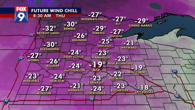
Christmas Eve is looking to get off to a bitter cold start, according to the latest wind chill projections. (FOX 9)

Winter storm warnings, watches and advisories are in place for Wednesday as accumulating snow is expected to spread across Minnesota.

The same system responsible for the snow will also bring strong northwest winds creating near whiteout conditions and dangerously cold wind chills.

The Twin Cities metro area could get more than 6 inches of snow Wednesday, with wind gusts reaching near 50 mph that evening.

That northwest wind will continue into Christmas Eve morning, bringing dangerous wind chills to the region. Minneapolis-St. Paul International Airport is projected to have a wind chill near -20. 

That's a big swing in "feels-like" temperatures in a short period, as the wind chill Wednesday morning is only expected to be in the 30s.

Stay up to date on the winter weather by downloading the FOX 9 Weather App. It has the latest temperatures, snow totals, forecasts and school closings 24/7. Download it for Android or Apple

Winter WeatherMinnesota