

Tropical Storm Alex forms after dropping more than a foot of rain over Florida
A tropical disturbance that produced flooding rain across South Florida has now exited off the coast into the Atlantic Ocean, where conditions allowed the system to organize enough to become Tropical Storm Alex on Sunday morning.
At last the report, the tropical storm had sustained winds of around 50 mph and was moving away from the Florida coastline.
Tropical Storm Alex is the first named cyclone of the 2022 Atlantic basin hurricane season, which kicked off on June 1.
Because of the threat of how close the system could come to Bermuda, a Tropical Storm Watch has been issued for the island nation.
Despite the system heading away from the U.S., rip currents will remain elevated along beaches for much of the Southeast through the workweek.
TROPICAL RAINMAKER CREATES DANGEROUS FLOODING IN SOUTH FLORIDA
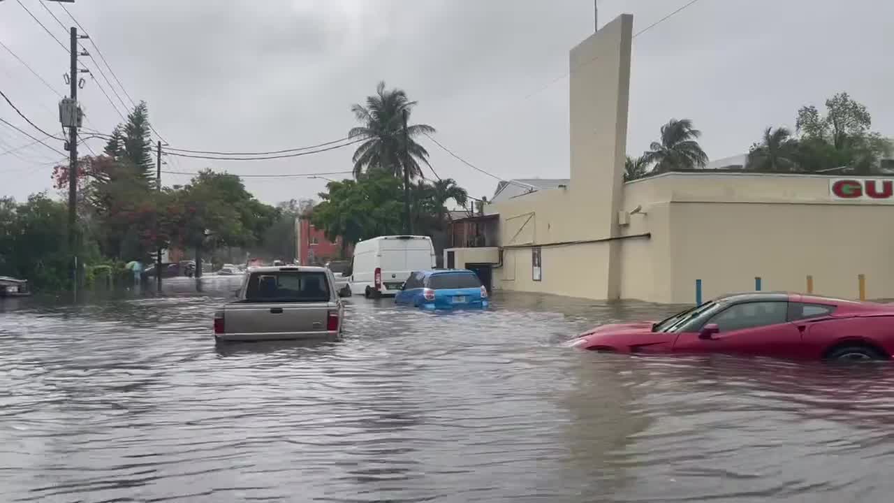
As the system passed over Florida, heavy rain caused flash flooding in Miami and coastal communities during the early morning hours of Saturday.
The City of Miami Fire Rescue responded to multiple calls of people stranded inside their vehicles after becoming stuck in floodwaters.
"A band of torrential rain caused widespread flooding up to waist-deep in the Miami area overnight, with other areas nearby also affected," said FOX Weather Hurricane Specialist Bryan Norcross. "The National Weather Service radar in Miami shows that a north-south swath of intense thunderstorms dumped 6 to over 12 inches of rain from Hallandale Beach, which is just south of Fort Lauderdale, down Interstate 95 through Miami to the upper Florida Keys. Three to 5 inches came all at once."
Miami received nearly a foot of rainfall and many other locations across South Florida reported nearly a month's worth of precipitation since Friday.

In addition to rain, the tropical weather created blustery conditions south of the Interstate 4 corridor.
On Saturday afternoon, Fort Pierce, Florida, reported a wind gust of 40 mph, and a weather station near Melbourne Beach, Florida, clocked a gust of 48 mph.
Wind gusts over 50 mph were previously recorded in southern Florida at Turkey Point (56 mph), Dania Beach Pier (52 mph) and Key West (51 mph).
The winds were responsible for occasional power outages, but as of Saturday evening, most customers' electricity had been restored.
Florida was not the only area that experienced life-threatening impacts from the disturbance.
In Cuba, authorities reported that the heavy rainfall caused landslides, and there were at least two deaths attributed to the system, near the capital city of Havana.
WHAT TO DO WHEN HURRICANE OR TROPICAL STORM WATCHES AND WARNINGS ARE ISSUED FOR YOUR TOWN
Strong upper-level winds have prevented the system from becoming better organized. The system remains very lopsided, with most of the heavy rain and gusty winds occurring well to the east and southeast of its center.
The average date of the first named cyclone is June 20, so the 2022 season is running slightly ahead of normal.
FOX Weather will be extensively covering hurricane season, and the FOX Weather app is a great resource to keep you informed and has a 3D radar that you can use to track storms. The free FOX Weather livestream is also available 24/7 on the website, app and on your favorite streaming platform. The FOX Weather Update podcast also provides weather information for the entire country.