

MN weather: Snow totals from Saturday, Feb. 8

MN weather: Snow finishes, temperatures drop
FOX 9 Meteorologist Cody Matz has your Saturday night forecast after snow fall this morning.
MINNEAPOLIS (FOX 9) - The second-largest snowstorm of the season yet hit Minnesota Saturday, and some areas are seeing big differences in the amount of snow accumulated.
Minnesota snow totals

Minnesotans outside to enjoy the newly fallen snow
Minnesotans flocked to the outdoors after a snowstorm hit the state. FOX 9's Babs Santos has more.
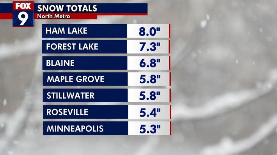
By the numbers:
Snow ranged widely across the Twin Cities metro, with most areas receiving 3–7 inches of snow. A band across central Minnesota saw the most snow, while the northern and southern parts of the state saw less.
Here's a look at the snow totals:
Snow totals for parts of Minnesota from Saturday's snowstorm. (FOX 9)
- Ham Lake: 8 inches
- Silver Lake: 7.9 inches
- Forest Lake: 7.3 inches
- East Bethel: 7.2 inches
- Isanti: 7 inches
- Mounds View: 6.8 inches
- Anoka: 6.7 inches
- Ashby: 6.6 inches
- Elk River: 6.5 inches
- Blaine: 6.5 inches
- Coon Rapids: 6.5 inches
- Osseo: 6 inches
- Cambridge: 6 inches
- Hugo: 6 inches
- Zimmerman: 6 inches
- Stillwater: 5.8 inches
- Maple Grove: 5.8 inches
- Shoreview: 5.8 inches
- St. Cloud: 5.7 inches
- Columbia Heights: 5.6 inches
- Champlin: 5.5 inches
- Plymouth: 5.5 inches
- Roseville: 5.4 inches
- Minneapolis: 5.3 inches
- Montevideo: 5 inches
- Bayport: 5 inches
- Little Falls: 5 inches
- Alexandria: 4.5 inches
- Morris: 4.2 inches
- Buffalo: 4 inches
- Wadenda: 4 inches
- Hinckley: 4 inches
- Eden Prairie: 3.8 inches
- Chanhassen: 3.5 inches
- Victoria: 3.3 inches
- Minneota: 3.1 inches
- Apple Valley: 3 inches
- Eagan: 3 inches
- Bricelyn: 3 inches
- MSP Airport: 2.9 inches
- Prior Lake: 2.8 inches
- Delano: 2.6 inches
- Red Wing: 2.5 inches
- New Prague: 2 inches
- Rochester: 1.5 inches
- Blue Earth: 1.4 inches
- Duluth: 1 inch
- New Ulm: 1 inch
Wisconsin snow totals
Wisconsin was also hit by the snowstorm, with some parts accumulating about 7 inches of snow:
- Boyceville: 7.1 inches
- Balsam Lake: 6.5 inches
- Osceola: 6 inches
- Woodville: 5.1 inches
- Menomonie: 5 inches
- Webster: 5 inches
- River Falls: 2.5 inches
Temperatures drop leading to cold week ahead
What's next:
Temperatures are expected to drop tonight, with some areas reaching below zero. The night will be calm with some wind, with the sun coming back on Sunday.
Clouds will increase Sunday afternoon, but should be generally quiet, with temperatures popping back up into the low 20s.
The week ahead is expected to be very cold, with temperatures dipping to the teens Monday and single digits Tuesday.
The Source: FOX 9 weather forecast.