

Minnesota weather: Pleasant Sunday, then the heat is coming back

MN weather: Pleasant Sunday, hot week ahead
Enjoy the slightly cooler weather on Sunday, with temperatures in the low 80s, before the heat returns full force during the week.
MINNEAPOLIS (FOX 9) - Enjoy the slightly cooler weather on Sunday before the heat returns full force during the week.
The weekend will end with temperatures closer to average for this time of year in the low 80s, and much less humid and sticky from Saturday’s excessive heat warning and dew points in the 70s.
Expect some sunshine and clouds throughout the day on Sunday and a slight breeze. Overnight temperatures will dip to about 65 degrees.
Starting Monday, the heat is picking up again with temperatures in the upper 80s and reaching the 90s by Tuesday, even flirting with triple-digit temperatures midweek. Saturday marked the 24th day in the 90s this summer. The Twin Cities metro averages 14 a year.
However, triple digits in August are rare. Since record keeping began in 1873, there have only been seven days when temperatures in the Twin Cities metro reached 100 degrees or higher, the last time being in 1988. The latest we almost hit triple digits was in 2021 with 99 degrees. We will get very close to recording 100 degrees this week, but it all depends on just how far north the warm front climbs on Tuesday and Wednesday.
Portions of southwest and central Minnesota, including the Twin Cities metro, are under an excessive heat watch from Monday until Thursday. The heat index could reach as high as 110 degrees for some areas under that watch.
The Minnesota State Fair kicks off on Thursday, and while there’s plenty of sunshine in store, it will be hot with temperatures expected to reach the mid-90s.
Here’s a look at your seven-day forecast:
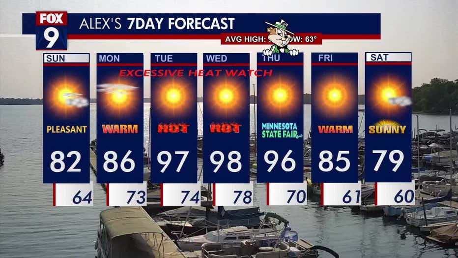
Here's a look at your seven-day forecast. (FOX 9)