

Minnesota weather: Tornado reported east of Albert Lea

Possible tornado near Albert Lea on Thursday
Tornado warnings were issued Thursday afternoon, with a possible tornado reported near Albert Lea.
MINNEAPOLIS (FOX 9) - Rain showers and cooler temperatures stuck around Thursday, but a warmer and brighter Friday is ahead.
Storms have mostly cleared the state, with only some light showers expected going into the night.
Here are live updates from the active weather day in Minnesota:
1:30 p.m. — tornado spotted near Albert Lea
Reported tornado:
The National Weather Service received the report of a tornado spotted by a weather observer east of Albert Lea between the city and Hayward, Minn. The tornado was moving northeast.
A tornado warning was issued for the storm but has since expired. The NWS received a report of potential damage from the storm in the area of the Rainbow Terrace Mobile Home Park on the south side of the city. The reported damage included trees and power lines down.
1 p.m. — tornado watch issued
Tornado watch:
The National Weather Service issued a tornado watch for parts of southeastern Minnesota, northeastern Iowa and southwestern Wisconsin until 8 p.m. on Thursday.
There's a chance for strong storms to develop with the opportunity for tornadoes, isolated hail and strong wind gusts.
At 1:30 p.m. the NWS issued a tornado warning for areas of Albert Lea, Clarks Grove and Geneva in southern Minnesota. The warning is set to expire at 2:15 p.m.
More rain Thursday, severe weather risk

MN weather: More rain with cloudy skies Thursday
It's another rainy day with overcast skies and cooler temperatures in the 60s. Friday is expected to be brighter and warmer, with highs in the 70s. FOX 9 meteorologist Jared Piepenburg has the full forecast.
Severe weather risk:
Additional rain on Thursday comes after Wednesday's weather where severe storms raced across southern Minnesota and at least 10 tornadoes were reported. The Twin Cities and areas west dealt with flash flooding after heavy rain, with some regions seeing over 4 inches of rain.
The afternoon hours on Thursday will see a threat of supercells and some lines of strong storms developing in parts of southeastern Minnesota, northeastern Iowa, and southwestern Wisconsin. These storms will have a chance to produce a few isolated tornadoes with the main threat being strong wind gusts. This set up is similar to what we experienced on Wednesday afternoon.
There is a level 2 risk of severe weather for southeastern Minnesota and a level 1 risk for areas just north on Thursday.
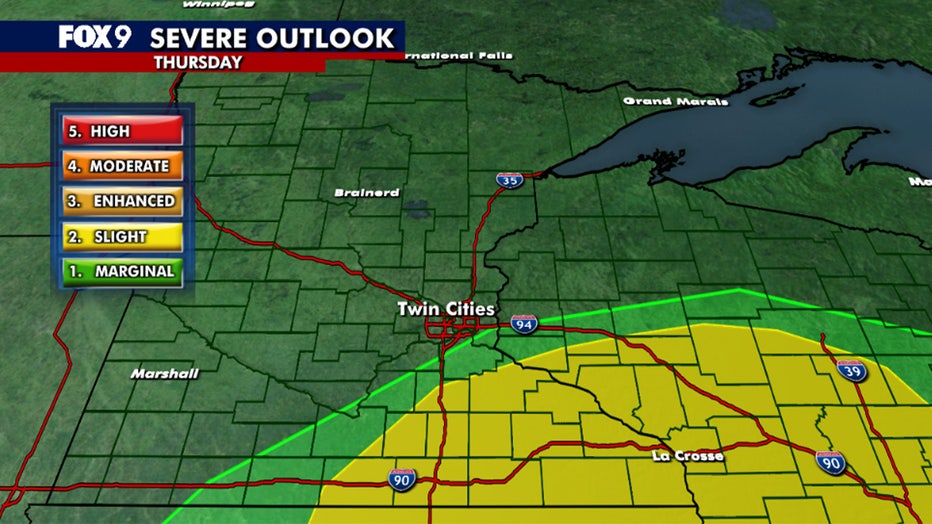
(FOX 9)
Thursday's forecast:
The Twin Cities will see periods of light to moderate showers with rumbles throughout the day. The system will likely bring another half inch of rain for some, with southern regions possibly getting another 1 to 1.5 inches of rain. The system finally moves out by mid-to-late evening, though the clouds will linger overnight.
Temperatures remain cooler with highs in the 60s statewide, accompanied by light northerly winds at 5-15 mph. The Twin Cities metro daytime high is around 67 degrees.
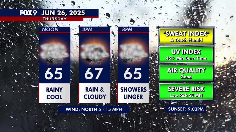
(FOX 9)
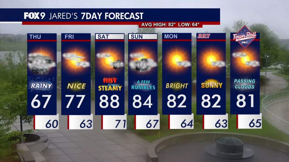
Nice Friday ahead of steamy weekend
What's next:
We get a break from the rain on Friday with partly sunny skies, light winds and highs in the mid to upper 70s.
This weekend is looking hot and steamy with rising dew points and temperatures in the mid to upper 80s. There’s a chance of a stray thunderstorm Saturday, which may linger into Sunday.
The start of the week is bright and comfortable with highs in the low 80s.
Here’s a look at the seven-day forecast:
(FOX 9)