

MN weather: Storms roll in, prompting warnings near metro
MN weather: Storms prompt warnings near Twin Cities metro
FOX 9 Meteorologist Erika Mrazki is tracking storms in Minnesota Tuesday night, some that are prompting warnings near the Twin Cities metro.
MINNEAPOLIS (FOX 9) - After a day of patchy sun and a high in the 70s, scattered thunderstorms are rolling across Minnesota Tuesday afternoon and evening.
Severe Thunderstorm warnings near metro
What we know:
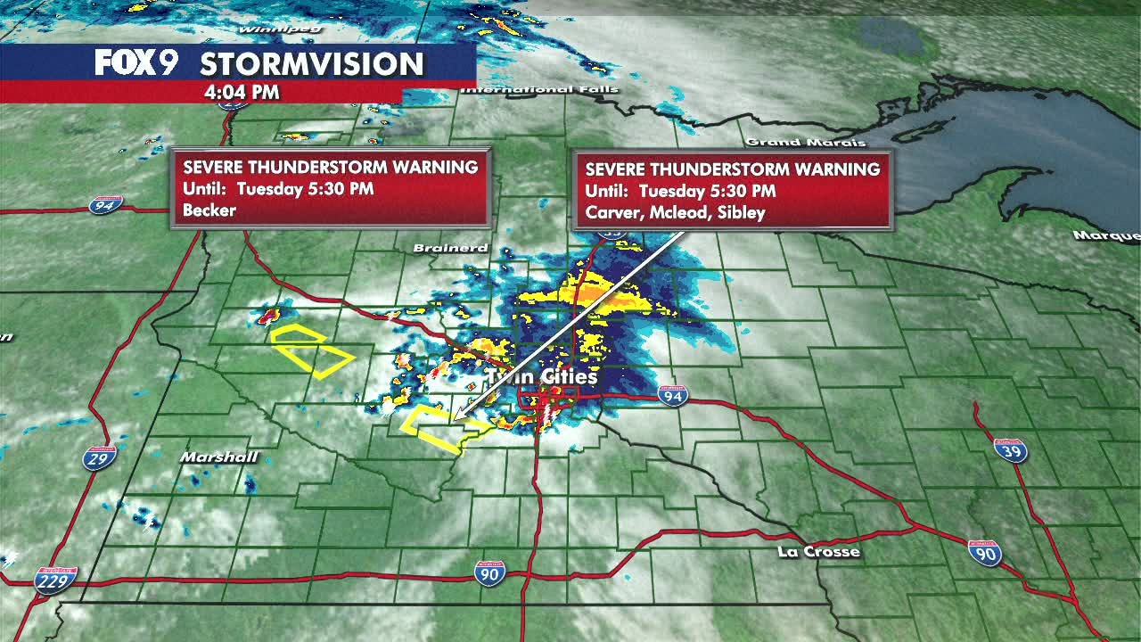
The National Weather Service issued a Severe Thunderstorm Warning for McLeod, Sibley and Carver Counties until 5:30 p.m. The areas impacted include Arlington, Glencoe and Henderson, which are west of the Twin Cities metro.
Becker County in northwestern Minnesota is under a Severe Thunderstorm Warning until 5:30 p.m.
Kandiyohi and Swift Counties are under a Severe Thunderstorm Warning until 6:15 p.m.
The threats with these severe storms include 1-inch hail, winds up to 60 mph and heavy downpours. An isolated tornado can't be ruled out.
Power outages
What they're saying:
Minnesota Valley Co-Op electric company is reporting at least 3,000 customers without power Tuesday evening in Carver and Scott Counties.
Xcel Energy is also reporting at least 1,000 customers without power in the Eagan area. An outage was also reported in Minnetonka, impacting at least 1,500 customers.
What we don't know:
It’s unclear if these outages are directly weather-related.
Severe weather risk
The backstory:
Western Minnesota remains under a level 1 marginal risk for severe weather, while a small portion is under a level 2 slight risk. A few storms could produce quarter-size hail, gusty winds, and brief heavy rainfall. The more severe weather is staying southwest of Minnesota in parts of Colorado, Kansas, Oklahoma, Texas and Nebraska.
The greatest chances for these stronger storms run between 3 p.m. and 9 p.m., on Tuesday. Most storms fade through the evening, though a few showers may linger across northern Minnesota overnight. Lows settle into the 60s.
Extended Minnesota forecast
What's next:
A few isolated storms are possible Wednesday afternoon, mainly along and north of the Interstate 94 corridor. Any pop-up activity fades quickly after sunset.
Thursday and Friday look dry and comfortable, with plenty of sunshine and highs in the 70s.
Conditions begin changing by the weekend as humidity increases. Highs climb into the low 80s Saturday and the upper 80s Sunday. Temperatures will climb into the 90s heading into next week.